ÇATALHÖYÜK 1993 ARCHIVE REPORT
    |
Fluxgate Gradiometer Survey at Çatalhöyük
Colin. A. Shell
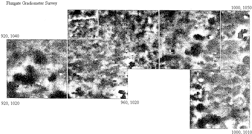
A magnetic survey was undertaken at Çatalhöyük in conjunction with the controlled scraping exercise to investigate the ability of a fluxgate vertical magnetic gradiometer to detect features associated with mud brick structures that may be encountered near the surface of the mound. Areas were surveyed adjacent to and over four of the scraped areas. Measurements were made at 0.25 m intervals along northward lines within 20, squares, the lines being at 0.50m separation using a Geoscan Research FM36 instrument. The data was logged internally and later processed in a portable microcomputer to produce random dot density plots.
The fluxgate gradiometer had a reading resolution of 0.1nT, with the stability of the measurement closer to 0.5nT. In general the readings ranged between -5nT and +5nT, except were burning was detected, giving higher intensities up to 50-60nT. The sensitivity of the instrument allowed certain mudbrick walls to be detected, and in other cases the presence of a wall boundary was apparent through a difference in t he magnetic signature either side of it. The large areas surveys, such as the one illustrated, give and overall magnetic image of the near surface structure of the ground. High intensity regions, shown as dark areas, correspond to burnt sediments and hearths near the surface. Very few high values (100-200nT) associated with iron objects were encountered.
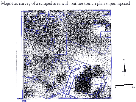
The large area plot of the data has distinct regions of burning, between which finer structure is apparent, within these rectilinear patterns are visible that correspond to underlying structures. The second illustration shows the plan of a scraped area superimposed on the magnetic plot. In the south east corner the light low intensity area corresponds with a mud brick wall, to the east of which is a large area of burnt sediment around a second low intensity mud brick wall. The light square feature in he northwest quadrant is caused by the stepping down of the ground within the scraped area and is typical of the effect of changing height of the instrument above the ground. This becomes noticeable at the low intensity level at which the readings had to be made. However, it is clear that the magnetic survey has resolved both mud brick walls and other significant features, particularly burning of the soil. It is proposed to continue the survey in conjunction with the scraping programme, and also to investigate other geophysical techniques that may give fuller information about the deeper structure of the mound.
| |
© Çatalhöyük Research Project and individual authors, 1993