ÇATALHÖYÜK 1996 ARCHIVE REPORT
    |
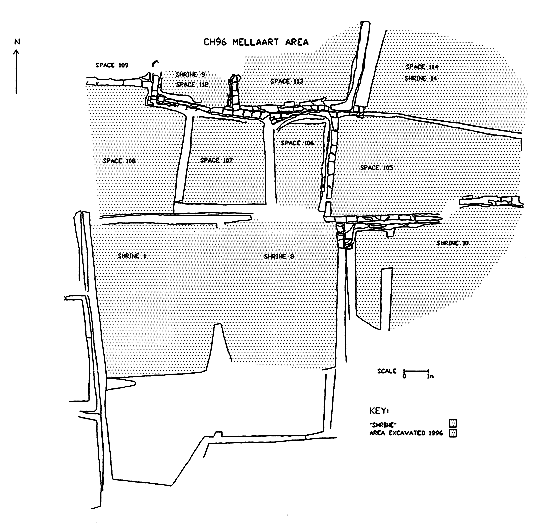
Area Mellaart Summary of Results
Shahina Farid
Introduction
During the course of the 1995 season a 20 m square area was defined in the Mellaart area for continued research and investigation. The marked area was cleared of erosion and backfill accumulated during and since the 1960's excavations and cleared to the level where Mellaart's work stopped in all defined structures except shrines 1 and 8. The east-west line of structures lying to the north of these two shrines were targeted for excavation this season. From the west, Mellaart had partially excavated level VIII ‘midden' in house 12 most of the level VII floors in houses 2 and 16 and to the east of courtyard 15 had been exposed to level VIII at the eastern end with remnants of level VII to the west.
Abstract
To the east a building was defined comprising a small eastern room, space 116, and a larger room, space 117 to the west. The floor levels were not reached by the end of the season and the western extent of the building has yet to be articulated. The infill of the building consisted of large dumps of building debris derived deposits. Through these dumps, an as yet isolated east-west aligned south wall was constructed, sealed by further dumps. Overlying these homogenous dumps were a series of domestic type waste deposits that covered the entire area under excavation. Space 115 represented this ‘external' ‘midden' area. Through these deposits an isolated, east-west aligned south wall was constructed towards the west, followed by a further period of ‘midden' accumulation. Mellaart's horizon of level VII buildings was constructed over the ‘midden', space 115 (see plan of the area).
Archaeological Sequence
Space 116 and 117 were semi-articulated at the east end of the excavation area, representing the earliest deposits exposed this season. The spaces appear to form a single building unit as a party wall divides the smaller space 116 to the east from space 117. The building is defined by wall 64 to the north, wall 65 to the east, wall 79 to the south and wall 66 forming the party wall. The western extent of the building was not defined this season. In the NW corner of 116 feature 72 formed a thin walled basin/storage bin. No floors, occupation or activity horizons were reached this season and already the walls stand about a metre high. The backfill comprised homogenous deposits of building debris derived dumps. These appear to be deliberate infilling deposits of building deposits as opposed to slow accumulation through erosion and collapse.
A later structural phase was represented within the accumulated infill of the building. Wall63 was constructed in a foundation cut 1626. This wall lay on the same alignment and partially cut into wall79, the south wall of spaces 116 and 177. The central section of this wall was excavated only this season leaving an extant section to the south of space 116. There was no evidence for continuation or return at its eastern end, presumably due to the erosion sine the 60's excavations. The western end of the wall was cut by the construction of a later wall and there were no contemporary walls to the west or north. Although this wall stands in isolation, it is possible that associated walls exist beyond the area of this seasons excavation, which may also explain the absence of any associated floors, surfaces, occupation or activity horizons.
This construction horizon was sealed by further homogenous dump deposits, similar to those that the wall was cut into.
These deposits were not excavated over the length of the excavation are but their continuation westwards beyond the temporary section, were observed in section and therefore it is likely that a similar sequence of infilled buildings exist to the west.
Sealing the dumps of building infill were a series of fine layers and interdigitated lenses of ash, charcoal, clay and deposits identified as ‘organic' matter, either food debris or coprolite. These deposits appear to be single primary deposition events of domestic/occupation debris i.e. hearth or oven rake out. Whilst they appear to have accumulated in fairly quick succession as there were no visible surface disturbance that would result when loose, fine ashy layers are exposed to the elements or human or animal activity. However, the primary deposition of the organic waste, micromorphological analysis of these deposits is important for such questions.
These ‘midden' deposits extended across the entire length of the area represented as space 115. (Space 115 lies below spaces 105). The ‘midden' also continuos north, beyond the limit of this seasons excavation but appears to respect the southern walls where shrines 1 and 8 continued in uninterrupted use. The ‘midden' also lay on a gradual slope from east to west and a very slight slope from north to south.
Towards the west the accumulation of these deposits was interrupted by a structural phase represented by wall 77. The extent of this wall that comprises two construction events, was limited to a stretch of 2.2 m on an east-west alignment, about 0.3 m north of the south walls. It was cut by the previous excavation to the west and its eastern extent was not traced. The early phase was constructed within a foundation cut 1691, represented by bricks 1826. It was rendered in a continuos application of plaster 1688 on its north face and west terminus, thereby represented a feature of one side of an opening. The plaster also lipped northwards at the base which presumably represented the surface/activity horizon associated with the wall. The plaster however, just barely lipped at ‘floor' level, having been either worn and eroded or cut subsequent activity in the area.
An additional length abutted to the west terminus represented the later phase of this wall. Constructed within the foundation cut 1831 the bricks and mortar are represented by 1825. Between the two constructions were brick fragments, the different brick types represented by 1828 and 1830. The function these fulfilled is unclear, possibly used as a gap filler or a bonding agent. There was no evidence for contemporary or associated walls, neither any substantial activity/occupation horizons. As with the earlier wall 63, to the east, subsequent ‘midden' accumulated against wall 77.
Constructed over the ‘midden' were spaces 108, 107 and 106. The north-south party walls of these areas were excavated this season, whilst the north and south walls are still in extant. The walls were constructed in shallow foundation trenches that stepped from north to south and east to west, a terracing exercise that Mellaart recorded during his campaigns and one that follows the contours of the mound. The shallow nature of the foundation trenches belie their function as stabilisers and could therefore have represented marker trenches for the erection of the walls instead. The stabilising factor is possibly reflected in pits excavated below the corners of the walls. Some form of consolidation would have been necessary over the soft and therefore unstable ‘midden' and the location of pits at the corners of the building performed such a function. The pits contained solid clayey fills with some redeposited ‘midden' but otherwise were fairly sterile.
Wall 58 was constructed in a shallow cut and divided space 105 from 106. Wall 57 divided spaces 106 and 107 and featured a small unplastered opening 62 towards the south. Wall 51 divided space 107 and 108 and also had an opening 55, towards the north. This opening was relatively substantial in size and neatly finished with plastered sides in a continuous application with plaster to the east and west faces of wall 51. Walls 51 and 57 bond with the north and south walls, however, wall 58 continues beyond the area of excavation to the north, and any relationship to the south has been lost to erosion. There was no trace of a southern wall to space 106, therefore it is possible that the southern limit was defined by the shrine 8 north wall.
Mellaart excavated these spaces as level VII, houses 12, 2 and 16. Although he had excavated most of the occupation horizons of these structures there were surviving remnants of floors and features both in space 108 (house 12) and space 107 (house 2). No activity, occupation of otherwise, was represented in space 106 where massive and homogenous layer of mixed clay filled the space, 1 meter higher than the floor level in space 107 and lying directly over the ashy ‘midden' deposits. This clearly illustrates an alternative function to that of space 107 and 108, possibly as an open alley area.
The sequence of construction therefore appears to be the construction of the walls, within foundation of marker trenches and over foundation pits at the corners. The pit to the north of wall 57 contained a complete equid (?) scapula, does this ritual or discard? The basal brick courses of some walls may have been fashioned in situ and therefore formed slabs rather than bricks. Levelling deposits were laid within the walls either as consolidation packing for subsequent floors or as ground levelling. Both sealed by cutting the levelling deposits were shallow pits of uncertain function. These may also have formed some consolidation function or may represent midden extraction pits. Midden was used as a mixture in some bricks but mostly mortar. The internal faces of the walls were plastered in space 107 prior to the consolidation of feature 15, a small shallow basin/bin located in the Northwest corner. This feature remained in use throughout the life cycle of the space and as such freshly rendered with plaster some contiguous with wall and floor application.
A fine dusting of red ochre was uncovered in front of opening 55 in space 107. It is not clear whether this was over floor or construction related deposits. The ochre was in dust form rather than an applied paint which raises questions as to its point of origin and function, does it represent accidental spillage or a ritual foundation deposit.
The floor in space 107 survived on over the western half of the space where the surface horizon sloped westwards and traceable through the opening over the shallow step. A red stripe was painted along the length of the lower step, possibly forming a decorative function. The floor in both spaces were contiguous, comprising fine lenses of plaster with a fine mud packing between each floor and wall plaster application. At this phase the three phases formed one building unit linked by the openings and divided by party walls.
A later phase is represented by blocking inserted in the openings. Whether the two openings were blocked contemporaneously is not known, but spaces 108 and 107 continued to function as a stand alone spaces as is illustrated by the later floors in space 107 that abutted the blocking.
Space 108 appeared to have undergone a complete refurbishment. Mellaart excavated this phase of activity and from his plans and remnants of extant deposits it appears that post-blocking, a series of platforms were constructed against the walls. One such platform abutted the blocking which would account for the absence of post-blocking abutting floors in space 108, as the floors would have abutted the platform. Pillars were also present, in the Northeast corner and centrally positioned along the east wall. Two post blocking pits happen to be located in the location of these pillars. The pits slightly undercut the lower wall face. Could these represent the foundation pits for the pillars?
A late phase to the construction wall 58 to the east is represented by the construction of walls 56 and 78. Wall 56 abutted the east face of wall 58, constructed in a foundation cut 1043 that cut through midden deposits and the west end of wall 63 in space 105. This foundation cut continues to the north and respected wall 58 to the west. The bricks were constructed in situ and as the wall was erected the foundation cut gradually filled side by side raising the ground surface, this was possibly deliberate to aid the construction of the upper courses of the wall. One of the basal fills of the cut which was overlain by the wall consisted almost entirely of animal bone. Does this represent the debris from a ritual feast prior to construction or simply the residue of a workers meal.
Wall 56 was clearly constructed from the east side, however, the bonded southern wall 78, appears to have been constructed from the south. However, as this area was not excavated this season interpretations and conclusions must await future work. The equivalent northern has not yet been defined and to the east and Southeast the wall has suffered heavily from collapse and erosion. Gone too is any associated occupation/activity horizon.
Although this seasons work was concentrated in spaces 108, 107, 106 and 105, preliminary investigations took place in spaces to the north and south. Hence spaces 109, 112, 113 and 114 were cleaned of erosion but excavation was only conducted in space 113. This area was damaged by roots and animal action, so much so that it was difficult to define undisturbed stratigraphy from Mellaarts redeposited fill. Excavation began in the Southeast corner where there was a series of intercutting and recut pits. These may possibly be associated with at least two oven/hearth bases. Found within one of the recut pits was a cache of obsidian that maybe associate with a small plastered depression that contained micro obsidian debatage. Excavation in this area was minimal because of the time factor and therefore no interpretation of these features can be made as yet. However, it is clear that this space needs to be excavated in order to address the anomalies of space 106, both of which Mellaart had allocated to his level VII sequence.
Additional work was carried out on the walls in the Northwest corner of Shrine 10, south of spaces 105 and 106 where the tops of walls were excavated to avoid collapsed after the excavation season. This exercise revealed many horrors to solve next season.
Conclusions and Questions
Results and conclusions from the seasons work are minimal, however, the investigations have raised a number of questions for future work.
Overall the excavations have illustrated the problem of attempting to blanket phase the site as Mellaart appeared to have done, it is apparent that many more phases than Mellaart identified are represented, many that are internal rebuilds and refurbishment's and therefore unrelated to neighbouring properties. The site should be seen as an organic growth, abandonment, collapse and rebuild events as structure specific. Later buildings more often reflect the alignment and location of earlier structures, the size and basic ground plan. The would be dictated by the limitations of the area rebuild dictated by extant neighbouring buildings. However, some overlaps and encroachment into neighbouring areas does occur it is these events that will allow for a wider phasing of the site and then a possible understanding of the use of space.
A series of buildings lie below the ‘midden' excavated this season. The questions related to this sequence are many. What dictated the abandonment of certain buildings, could it be related to the end of a family cycle. Were they then left to collapse over time of deliberately in filled, was the backfill local or imported. What do the two very distinct types of ‘midden' represent. What kind of timespan are we dealing with, was the area deliberately backfilled in order to rebuild immediately or does the infill and midden reflect an opportunistic disposal of waste. What then dictated ‘redevelopment' of these ‘external' areas. Do the later structures constructed over the ‘midden' reflect the plan of the buried structures, if so, does this reflect a formalised, or ‘ritual', ground plan that was adopted. Is the redevelopment an opportunistic use of vacant ground or ‘family' unit specific that reflects clan or social expansion and contraction.
| |
© Çatalhöyük Research Project and individual authors, 1996