ÇATALHÖYÜK 1999 ARCHIVE REPORT
| |
Introduction: Çatalhöyük 1999
Ian Hodder
Introduction
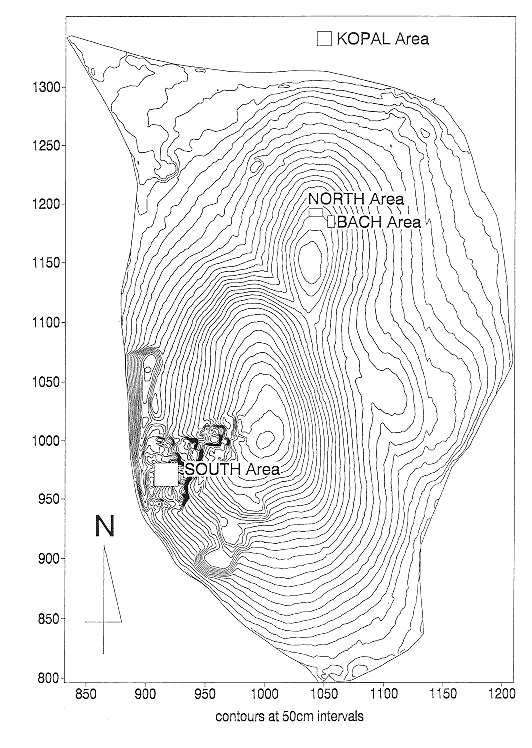
Çatalhöyük was excavated for 6 months from April 1 1999 (Figure 1, Figure 4). This long season was prompted by the need to evaluate possible damage to the lower levels of the site. The water table in the area around and under the site has dropped dramatically since the 1980s. This has caused drying out of the remains in the lowest levels. Do organic remains (wood, baskets, textiles etc) survive in these levels? Evaluation of this threat to the site also allowed investigation of the unexcavated lowest deposits. What was life at Çatalhöyük when the site began?
To answer these questions a team of 20 British, Turkish and international professionals worked from April to September. The team concentrated on digging a deep sounding down 6m to the base of the mound (Figure 2) in the South area of the site. During July, August and September the BACH team worked on the North of the mound on Building 3, and off the site to the north the KOPAL team excavated a large trench. The survey team led by Douglas Baird also joined us in the summer months.
However, our activities in 1999 were very much affected by the August earthquake. While this had no physical impact at the site, the emotional shock was severe. Some members of the team went to work in the worst affected zones. Those on site were thankful to Başak Boz for arranging a fundraising event at which the project and project members contributed $1000 to the relief effort and the earthquake victims. Public events such as our usual press day were cancelled.
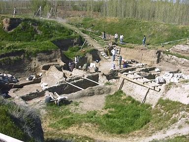
General view of South area in April 1999
The excavations
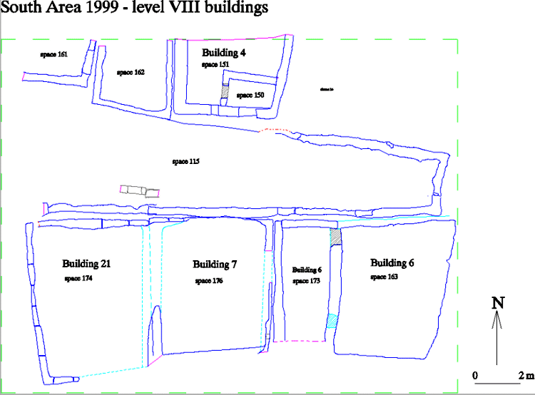
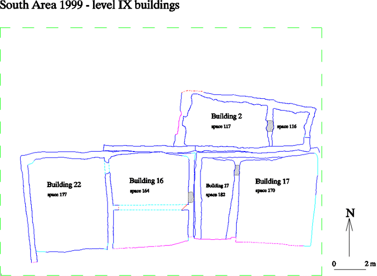
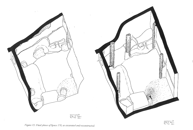
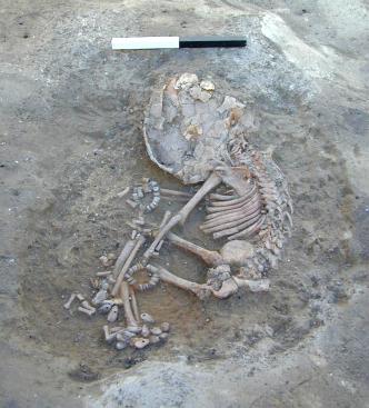
As we dug down in the deep sounding in the South area (Figure 4, Figure 13), we came across several houses (Figure 10 and Figure 11). Detailed investigation concentrated on Level IX, Building 17 (Figure 15). In much later phases of the site, excavated in the 1960s, this Building 17 became what James Mellaart called Shrine 10. Shrine 10 Level VI is the one that has been reconstructed in the Museum of Anatolian Civilisations in Ankara. In Level VIII of this building excavated in 1999, a large number of burials were found beneath the floor. These included some very special burials - indicating the importance of this building centuries before it was rebuilt as Shrine 10. One of the burials (Figure 5) was of a baby with bracelets and anklets. Other babies were buried in baskets made of specific types of wild grasses. These neonate baskets often made from the floral portion of the plant, indicating spring death. Another grave contained an adult covered with owl droppings - perhaps owls had special symbolic significance linking death to their night-time activities. A further burial (Figure 6) was of a man with legs apart and with a mat of reeds and a plank of hackberry wood laid on his chest. His head had been removed and we found cut marks on his neck bones. The removal of the head is shown in the art from Çatalhöyük.
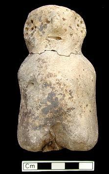
On the floors in Building 17 (Level IX) we found several platforms (Figure 15). different activities took place on different platforms. The lower part of the floor in the southeast corner was the dirty part of the house, with hearth and floor sweepings. But placed above a hearth in this area was a clay figure (Figure 56), one of the largest we have found at Çatalhöyük. Other platforms were cleaner, even near the ovens and storage bins found in the southwest and northeast corners. A zone of red painting and a raised border continued around the lower part of the plastered wall. Large pits in the floor had been dug in order to remove posts which had helped to hold up the roof.
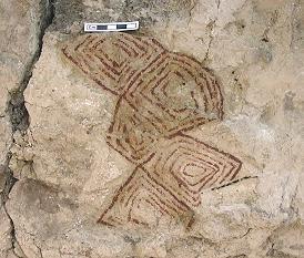
Other buildings found (Buildings 16/18 and 22/23 in Levels IX and X) contained hearths and ovens in the south parts, together with evidence for daily activities such as the knapping of obsidian and the making of bone beads. There seems to be some specialisation in craft production between different buildings, but obsidian knapping and storing seems to have been closely associated with hearths and ovens on the southern dirty floors in most buildings. Building 2 (Level IX) had traces of a geometric painting in the northeast corner (Figure 7). So we can see that symbolism and ritual as well as domestic activities occurred in all buildings, whether large and elaborate or small and simple.
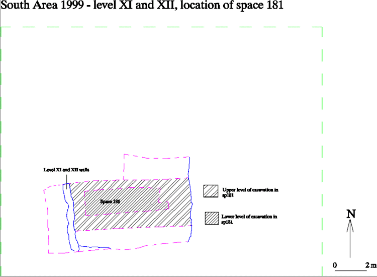
As we dug below Buildings 16/18 and 22/23, we came across a non-domestic, though probably roofed, area of Levels XI, XII with a building to the west in Levels XI and XII. Between surrounding buildings at this time were layers of stabling for herbivores, probably mainly sheep and goat.. This area had been used to keep animals, and their dung was found in deep layers. Beneath the layers of stabling prior to Level XII, we came across layers of rubbish or midden. Clearly at this early time in the use of the site, this area had been clear of houses and was used for refuse and for outside activities. For example, there was clear evidence of lime burning - that is the burning of the local marl at high temperatures in order to produce a lime plaster for covering floors.
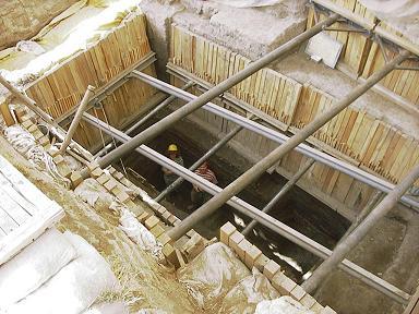
The deep sounding in the South area in September 1999
In these early pre-XII levels, we have found no pottery and we have a radiocarbon date of around 7500 BCE. Apart from the lack of pottery, other distinctive aspects of these early layers are clay shapes or balls in a variety of geometric forms, an obsidian industry with a microlithic component, large fauna and a wider variety of fauna.. There is a distinctive botanical assemblage with more fruitstones and nutshells and larger pulses and cereal grains. The painted lime plaster indicates that there are elaborate buildings on the site somewhere at this time presumably towards the centre of the mound.
A trench dug to the north of the site (KOPAL, Figure 4) has discovered no buildings, but has shown that certain activities, such as the processing and winnowing of crops took place here away from the settlement. There is also a distinctive fauna with many more cattle bones than are usually found on the mound. There had also been earlier phases of pitting into the marl, presumably to obtain raw materials for plastering walls. The dates suggested for this activity are pre-Level XII as many distinctive clay balls were recovered very similar to those at the base of the deep sounding in the South area. An alternative hypothesis is that these balls indicate off-site activity, but the lack of pottery in both areas probably indicates an early aceramic phase. The KOPAL stratigraphic sequence suggests that while the site was founded in a drier phase, most of the ceramic sequence was associated with very wet deposits around the site.
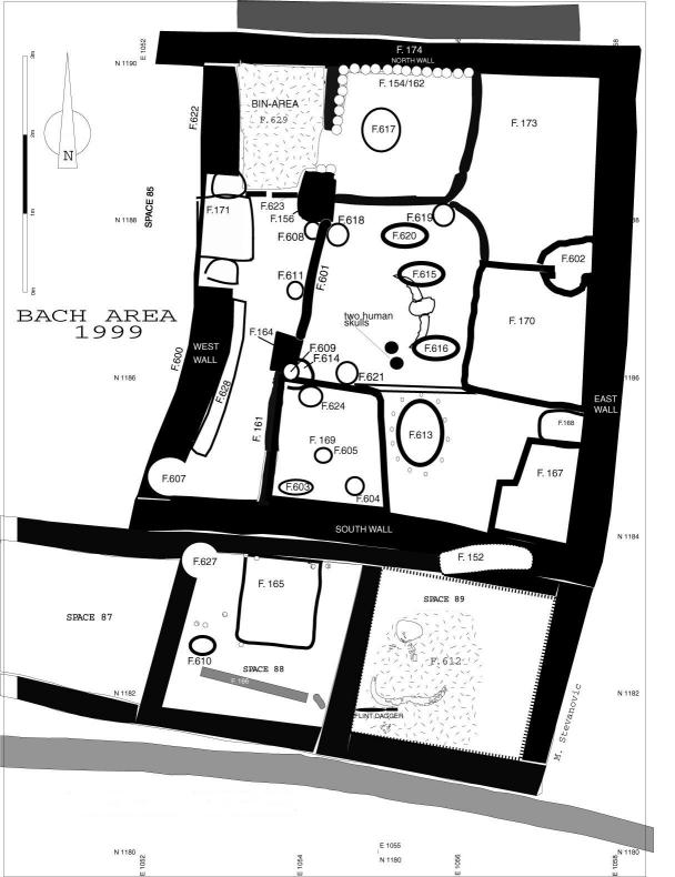
The BACH team based in Berkeley, University of California, has continued to excavate Building 3 (Figure 4, Figure 24). The main room is divided into several platforms, some in the centre and south of the main room associated with ovens and fire pits. The white plaster platform to the northwest is surrounded by red paint and has burials dug into it. There were also fallen bucrania (the skulls and horns of large wild bulls) and two human skulls on the floor of this building. Overall, this was a very elaborate and complex room. At the side a screen wall divided off a long room used perhaps for storage and other activities.
Conservation and Public presentation
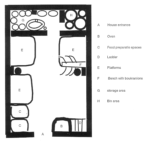
We have also progressed towards making Çatalhöyük the attraction to tourists that it deserves. Building 5 has been further conserved under the guidance of Frank Matero and a modern shelter has been constructed over it with the help of Lindsay Falk, David Small and Arup Istanbul. This shelter has a wooden floored display area and a bridge built so that visitors can view the well-preserved walls, ovens and storage bins (Figure 3). Progress has also been made in making a full-size reconstruction of a Çatalhöyük house (Figures 58 and 59) under the guidance of Mirjana Stevanovic. The walls have been built and next year ovens, sculptures and paintings will be added so that visitors can gain an idea of what it would be like to move round a house that was lived in 9000 years ago. The exhibits in the Visitor Centre on site have been added to thanks to the work of Orrin Shane.
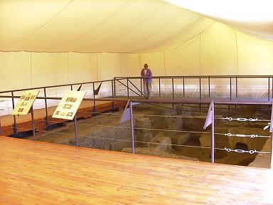
Inside the Building 5 Shelter
Conclusion and evaluation of threat to the site
The project was successful in achieving its primary aim in 1999 of evaluating the impact of the recent drop in water table on the site and in assessing best practice for the water level in future years. The KOPAL trench showed no evidence of waterlogged organic remains surviving, even though such deposits had been noted in 1997. An organic pseudomorph (possibly waterlogged) pointed to some level of waterlogging at that time. So there has probably been recent loss of waterlogged organic remains here.
The micromorphological examination of deposits from The South area deep sounding did identify mineralised uncharred plant remains, suggesting once wet conditions. But there is no evidence of when mineralisation occurred. There was no evidence of waterlogged plant macro-remains. This is not the result of recent local dewatering as sediments excavated at the base of the mound in 1999 were wet despite the recent drops in water table. However, the preservation of charred plant remains suggests a long term stable water level which needs to be maintained to prevent damage. It is also possible that features elsewhere in low parts of the mound or dug into the sub-mound soils may have waterlogged plant remains preserved. Again, therefore, we advise monitoring and maintaining present water levels.
Funding and acknowledgements
Excavating for 6 months with a fully professional team is expensive. Well over half a million US dollars were raised for 1999. The sources include Foundations and Research Councils in Britain and the United States of America (Arts and Humanities Research Board, British Institute of Archaeology at Ankara, McDonald Institute, Newton Trust, Kress Foundation, Dayton Foundation, National Geographic, Stanford Univesity). But about half of the total has been raised from corporate sponsors. The main sponsors are KoçBank, Boeing, Fiat and Visa. The Co-sponsors are Shell, GlaxoWellcome and British Airways. The long-term sponsor is Merko, and the IT sponsor Koçsistem. Other support has been provided by Eczacıbaşı, Arup, Meptur and the Turkish Friends of Çatalhöyük. The project in particular wishes to thank Ömer Koç for his continued support of the project in many ways. Assistance in fund-raising has been provided by the World Bank.
The project works in Turkey with a permit from the Ministry of Culture, General-Directorate of Monuments and Museums, and under the auspices of the British Institute of Archaeology at Ankara. We wish to thank our government representatives - Osman Ermişler, Recep Okçu, Edip Özgür, Candan Nalbantoğlu, Sema Dayan, Lütfi Önel. Much local support has been provided by the Çumra belediye başkanı and kaymakam.
Finally, our sincerest thanks go to Banu Aydınoğlugil for the Turkish translation of the introduction and the abstracts.
| |
© Çatalhöyük Research Project and individual authors, 1999