ÇATALHÖYÜK 2000 ARCHIVE REPORT
    |
Excavations, Area SP and TP1, East Mound
SP ve TP1 Alanındaki Kazılar
Shahina Farid
Abstract
No excavation took place in the North and South Areas this year as team members concentrated on post-excavation analysis of material and records collated since excavations in these areas began in 1995. This work is in preparation for the publication of these areas in three volumes planned for 2002.
Two new areas however, were investigated on the East mound in preparation for the arrival of a new excavation team at Çatalhöyük proposed for the 2001 season.
The first area was located on the lower slopes of the east mound where a gradiometer survey conducted in 1995 indicated a large rectilinear feature possibly of the Neolithic period. The excavation, however, revealed Classical deposits and architecture and as the purpose of this exercise was to define Neolithic archaeology and not to excavate later periods, the area was recorded and backfilled.
The second area was located at the crest of the mound, east of Mellaart's Area A where late Neolithic levels were expected. However, the initial area investigated defined classical deposits and associated burials. Therefore in order to find the exact location of the upper Neolithic buildings investigations were moved into Mellaart's trench. Levels I - III were identified by correlating the in situ archaeology with plans from 1961 and these traced into the eastern section.
The result is that in 2001 a trench will be located immediately to the east of this area to target Level I, but it is clear that the overlying late activity will first require excavation.
Özeti
Kazı çalışmalarının başladığı 1995 yılından bu yana birikmiş olan malzemenin ve belgelerin ekip üyeleri tarafından analiz ve değerlendirmesine konsantre olunulduğundan Kuzey ve Güney alanlarında bu yıl kazılara devam edilmedi. Bu yapılan değerlendirme ve analizler aynı zamanda 2002 yılı için üç ciltlik bir yayın olarak planlanmaktadır.
Bununla birlikte Doğu Çatalhöyükte iki alan planlanan 2001 sezonunda yeni bir ekibin çalışması için tetkik edilerek hazırlandı.
1995 yılında ilk araştırmaları yapılmış ve muhtemelen Neolitik döneme ait olabileceği düşünülen geniş ve dörtgen biçimli izlerin bulunduğu birinci alan tepenin aşağı yamaçlarında bulunmaktadır. Bu alan içinde gerçekleştirilen ufak çaplı kazılar sonucunda bu izlerin Klasik döneme ait oldukları anlaşıldı. Buradaki çalışmanın amacı Neolitik tabakaları belirlemek olduğundan bu alandaki çalışma belgelenerek birinci alan doldurularak kapatılmıştır.
İkinci alan Mellaart bölgesinin doğusunda yer almaktadır. Burada yapılan tetkiklerde yine Klasik döneme ait mimari ve gömülere rastlandı. Üst Neolitiğe ait yapı katlarını tespit edebilmek amacıyla çalışma Mellaartın eski açmalarının içine doğru kaydırıldı. Buradaki arkeolojik izlerden ve 1961 yılından kalan planların yardımıyla Neolitiğe tarihlenen I III nolu tabakalar teşhis edildi.
Bu çalışmalar sonucunda 2001 yılında bu alanın doğusunda bir açma açılarak yerleşmenin üst Neolitiğe tarihlenen tabakaların araştırılmasına karar verilmiştir.
Introduction
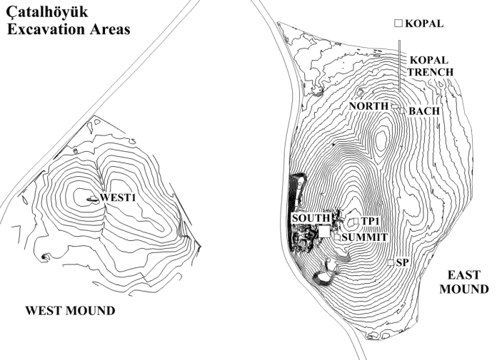
Two new areas on the east mound were investigated this season in preparation for the arrival of a new excavation team at Çatalhöyük proposed for the 2001 season (Figure 1).
The work was conducted by a team of Selçuk University students, Konya, over the month of August. Supervised by Shahina Farid the team was Meral Atasağun, Aslı Kutsal, Makbule Ekici and Mustafa Türker, they were also joined by Ömer Bilgin from Istanbul.
The work was conducted using a combination of surface scraping, a system adopted by Roger Matthews in 1993 - 1994 over the east mound (Matthews 1996), and partial excavation of colluvial deposits to expose the archaeological horizon.
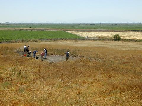
Area SP
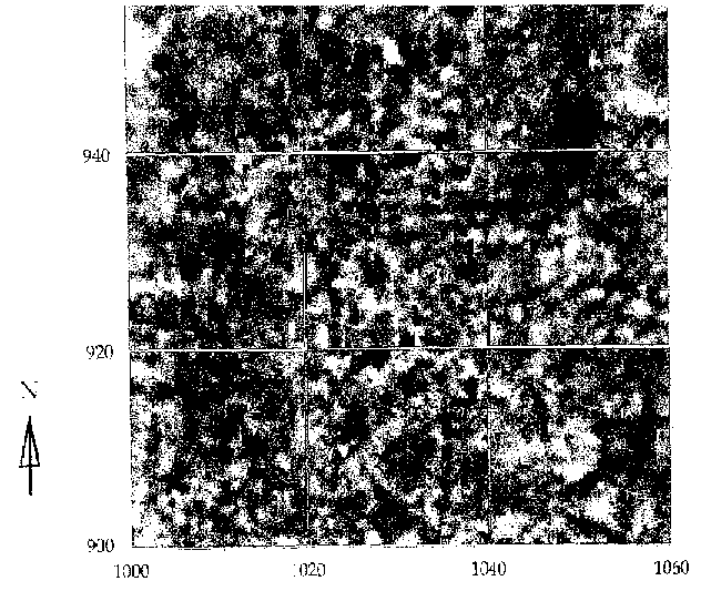
The first area investigated was situated to the south of the East mound at 1030/910 on the site grid (Figure 5). This area was targeted for investigation and possible excavation for 2001 on the basis of the results from Geoscan Research FM36 fluxgate gradiometer survey conducted by Dr. Colin Shell of Cambridge University in 1995. This survey indicated a large rectilinear feature of a size not previously encountered in the magnetic survey and possibly indicating a large mudbrick structure c. 8. m square (Figure 6). It was interpreted as possible mudbrick walls of up to 1 metre wide and although possibly of post-Neolithic date was of interest because it's orientation was the same as an area of Neolithic buildings a few metres to the northeast at 1035/925.
Prior to this no scrape squares had been conducted on the southern lower slopes of the east mound due to the amount of overburden requiring excavation rather than surface scraping. This was therefore the first opportunity to investigate this location. Accordingly a 10 x 10 m square was opened with initial vegetation and surface clearance of c.50mm (unit 6400). The area was then quandranted in order to localise artefacts for possible distribution patterns.
The NE quadrant was first reduced as a 0.10m spit of colluvial deposits [unit 6401], and the hand picked artefacts produced an assemblage of mixed periods. Some mudbrick material was identified at c. a 0.10m and to establish it's continuity and assess whether it represented in situ archaeology, the neighbouring square to the northwest was reduced to the same depth as unit [6402], and accordingly the southwest quadrant as unit [6403]. There were no equivalent mudbrick deposits in this quadrant which enabled further excavation. Five units of 0.10m depth spits were excavated (units [6404 6408]), before in situ deposits were revealed. The archaeology consisted of the scorched remains of a hearth [6409], located to the northeast of the quadrant. Unit [6411], was the fill of a pit cut, about 1.m in diameter, which was partially excavated and produced a mix of human and animal bone. This pit however, was not fully excavated. The pit, located in the centre north, cut the corner of a mudbrick wall [6410] and [6412]. This lay on an 0.8m east-west alignment, cut to the west by pit [6411], with a southbound return c. 2.4 m north-south and a further 1.3m east-west, running into the section in the southwest corner of the quadrant. The mudbricks were a standard 0.4m square and possibly dating to the Hellenistic Period. Unit [6413] represented the horizon where the investigation stopped, in order to locate various artefacts (pottery sherds and loom weights) across the horizon.
The artefacts from this area of investigation were scanned only, to define a dating period. All were identified as belonging to the classical Period.
Although the large structure that had shown up in the gradiometer survey was not defined the horizon reached was recorded and backfilled as the aim was not to excavate deposits of these late periods.
Area TP1
A further area was then targeted for proposed excavation in 2001. Discussions between Ian Hodder, Wendy Matthews and Shahina Farid decided that an area at the crest of the east mound would be investigated to define late Neolithic structures. To date the current project has concentrated on Levels VI and earlier but nothing later, it was considered important to bridge that gap. Accordingly plans and texts from Mellaart's excavations of the 1960's were referred to (Mellaart 1962; 1963; 1964; 1966; 1967; see also Hodder 1996a figs 1.8 to 1.17), to define a suitable area of excavation for such an investigation targeting Levels I and II but avoiding activity of later periods.
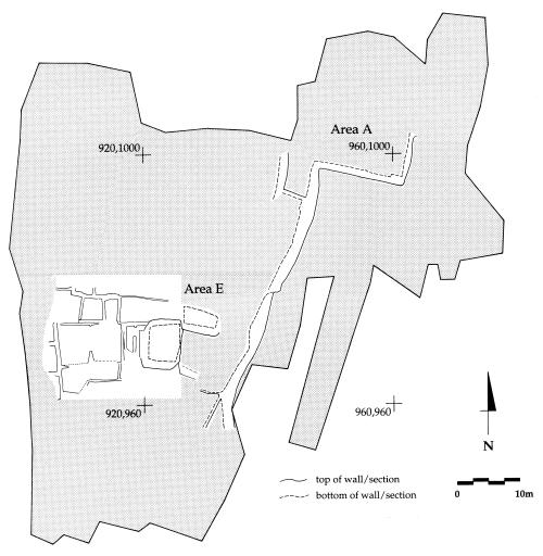
Mellaart's plans of Levels I and II (Mellaart 1962,fig 3; 1967, fig 4; Hodder 1996a, figs 1.8 and 1.9) were referred to as well as the contour plan published in On The Surface (Pollard et al 1996, figure 5.2), in order to estimate which contour these structures would be located at. Immediately to the south of Mellaart's Area A (Figure 7), Levels I and II (Figure 8), an unexcavated area was notated as 'S' Shrine and said to be an elaborate building (Mellaart pers. comm.). This area was therefore targeted.
Initially a 10 x 10 m area was surface cleared (unit [6420]), with a SW co-ordinate reading of 965/974. Initial investigation concentrated along the northern edge to find the continuation of an area marked on Mellaart's plan as 'street'. These deposits, unit [6421], were ashy, homogenous and heavily contaminated with classical pottery sherds and possibly represented backfill from the 1960's. After a depth of c. 0.3m and no trace of in situ Neolithic deposits the area was extended east to the edge of Mellaart's trench and south as far as a SW co-ordinate of 960/969. The extended area measured 15 m N-S x 20 m E-W and was surfaced cleared before concentrating along the western 8.m and in total reduced to a depth of 0.5m. These deposits were excavated in spits as units [6422] - [6436] and represented accumulated classical layers. All spits excavated produced late classical material and defined 12 burials (Figure 9). These were in supine positions located within mudbrick lined burial cuts. Generally these burials were defined only but some exposed bones were recorded and recovered. Due to the extent of the classical deposits and burials no further investigations took place, the area was recorded and backfilled.
Investigations were then conducted to the north, within Mellaart's Trench A, where Levels I and II had been excavated. The SW corner was at 970/984 on the site grid and the area cleaned to the Neolithic archaeology measured 7.m E - W x 10.m N - S. Topsoil was removed as [6437] and erosion and backfill as [6438] and [6439]. Other cleaning units were represented by [6447], [6448] and [6450]. These units all produced a mixed classical assemblage with occasional Neolithic pottery of Levels II and III (Jonathan Last pers. comm).
The archaeology exposed in section and plan comprised Levels I, II and III. In plan were a combination of Levels II and III mudbrick walls concentrated to the east on a N - S alignment (Figure 10). To the west of these structures was an area of heavily disturbed midden type deposits. One of the mudbrick walls defined in the east section could either represent Neolithic Level I or a structure from the classical period (Figure 11). In the NE section a small clay lined oven was associated with thick white pebble and plaster floor, this is also probably of the classical period (Figure 12).
The aim for 2001 therefore is to locate a trench immediately to the east of Mellaart's Area A, this will define the continuation of the Level I structures partially excavated in the 1960's. However it is clear that there is overlying late activity which requires careful excavation.
References
Matthews, R. (1996) Surface Scraping and Planning. In Hodder (1996b), pp 79-100
Mellaart, J. (1962) Excavations at Çatal Hüyük, first preliminary report, 1961. Anatolian Studies 12, 41-65.
Mellaart, J. (1963) Excavations at Çatal Hüyük, second preliminary report, 1962. Anatolian Studies 13, 43-103
Mellaart, J. (1964) Excavations at Çatal Hüyük, third preliminary report, 1963. Anatolian Studies 14, 39-119.
Mellaart, J. (1966) Excavations at Çatal Hüyük, fourth preliminary report, 1965. Anatolian Studies 16, 15-191.
Mellaart, J. (1967) Çatal Hüyük: A Neolithic Town in Anatolia. Thames and Hudson: London.
Hodder, I. (1996a) Re-opening Çatalhöyük. In Hodder (1996b), pp1-18
Hodder, I (ed) (1996b) On the Surface Çatalhöyük 1993-95 [McDonald Institute for Archaeological Research / British Institute of Archaeology at Ankara Monograph No.22]
Pollard, T., C.A Shell & D.R Twigg (1996) Topographic Survey of the Çatalhöyük Mounds. In Hodder (1996b), pp59-72
Figures
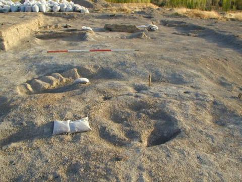
Figure 5: Location of SP, on lower slopes of East Mound, looking S.
Figure 6: Fluxgate Gradiometer Survey
Figure 7: Areas excavated in the 1960's.
Figure 8: Levels I and II as excavated by James Mellaart, 1961.
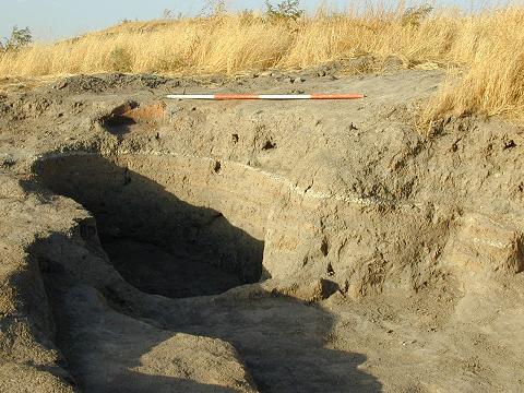
Figure 9: Area of Classical activity and burials
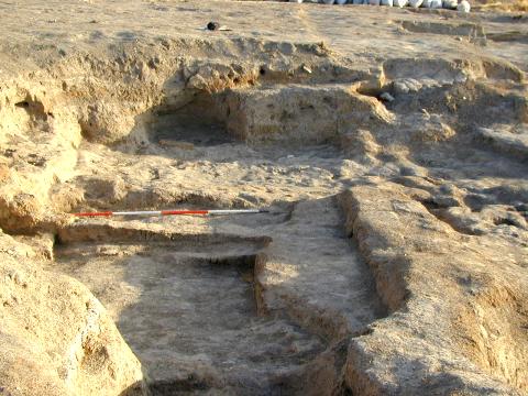
Figure 10: Levels I - III, looking south.
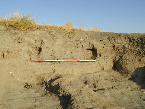
Figure 11: East section, showing Levels I - III
Figure 12: Oven and floor of Classical period in section
| |
© Çatalhöyük Research Project and individual authors, 2000