ÇATALHÖYÜK 2001 ARCHIVE REPORT
| |
The excavations of the TP (Team Poznan) Area in the 2001 season
2001 Kazı Mevsiminde TP (Team Poznan) Alanındaki Kazılar
Lech Czerniak, Monika Kwiatkowska, Arkadiusz Marciniak, Joanna Pyzel
Abstract
A section of 10 by 10 meters was excavated by the archaeological expedition from Poznan, Poland between 7th of June and 12th of July 2001. It is located in the highest point of the east mound. The occupation phases discovered during this season comprise late Roman and Byzantine periods. They represent later stages of the mounds life history and show that it was an important element of the cultural landscape in early historical times. The following occupation phases were identified: (1) Chalcolithic represented by numerous potsherds, (2) Late Roman/early Byzantine house, and (3) Byzantine cemetery.
Özet
10 x 10 metrelik bir alan, 7 Haziran ve 12 Temmuz 2001 arasında Polonya Poznan'dan gelen arkeoloji ekibi tarafından kazılmıştır. Bu alan, doğu höyüğünün en yüksek noktasında yer almaktadır. Bu sezonun çalışmaları, geç Roma ve Bizans dönemlerine ait tabakalar ortaya çıkarmıştır. Bu tabakalar, höyüğün geç dönemlerde geçirdiği süreçleri ortaya koyarak, höyüğün erken tarih dönemlerinde de kültürel peysajda önemli bir yerinin olduğunu göstermiştir. Aşağıdaki kullanım tabakaları ortaya çıkarılmıştır: 1) Çanak - çömlek buluntuları ile temsil edilen Kalkolitik, 2) Geç Roma/ erken Bizans evi, ve 3) Bizans Mezarlığı.
Introduction
It was the first season of excavation of a new area on the east mound. Work commenced on Jun 7, 2001 and was completed on July 13, 2001. It was conducted by a team of Institute of Archaeology and Ethnology, Polish Academy of Sciences and Institute of Prehistory, University of Poznan, Poland. A section of 10 by 10 meters was excavated in this area.
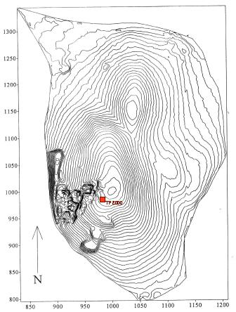
The primary aim of the season was to find and then continue to excavate a Neolithic house and to recognise two latest phases of the Neolithic occupation known as Levels I and II. Previous excavations concentrated on earlier phases and the current project is intended to bridge that gap. The crest of the east mound was believed to be ideal for recognition of the late Neolithic structures. The decision to open up a trench in this particular part of the east mound was preceded by the work conducted by a team supervised by Shahina Farid in the 2000 season. It used a surface scraping as well as partial excavation of colluvial deposits and contained are measured 25 meters x 30 meters. After a depth of ca. 30 cm no Neolithic structures have been traced here. Few deposits were excavated in spits and revealed existence of few burials. The bodies were in supine and extended positions located within mudbrick lined burial cuts. As a result of this work, it was decided to locate a trench immediately to the east of Mellaart's Area A, where Levels I and II had been excavated. The decision was also supported by study of Mellaart's plans of Level I and II (Figure 9).
Stratigraphy
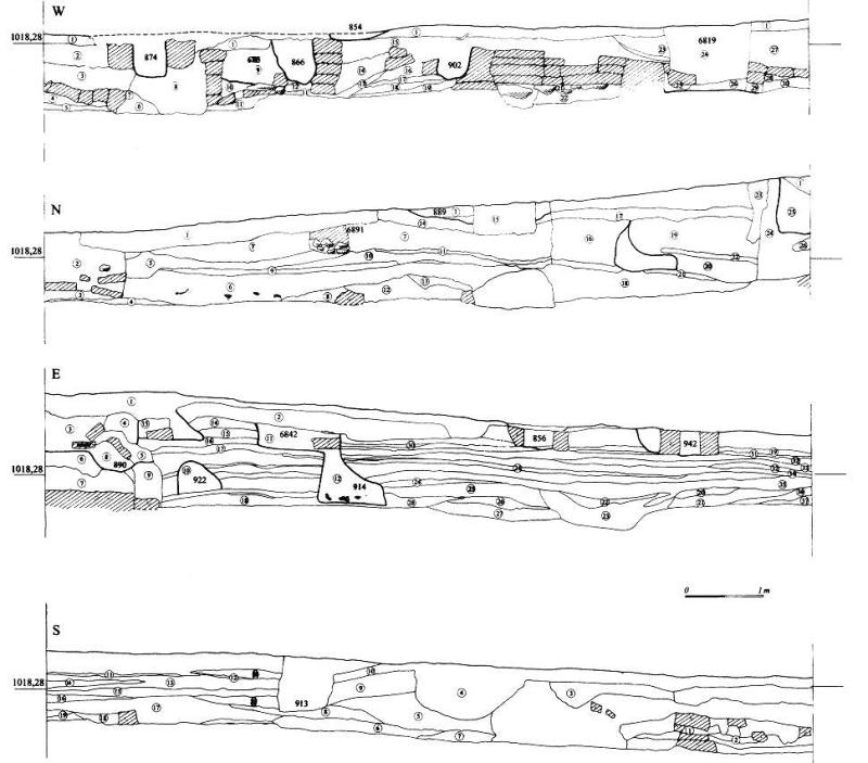
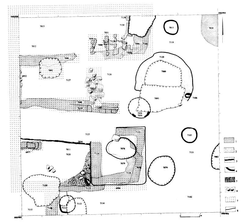
Analysis of trench cross-sections revealed division of the excavated area into two separate parts (Figure 10). Eastern part of the area has very characteristic tell-like compound layers, usually very thin and parallel to each other. They were only destroyed by later burial pits. Central and western part of the excavated area was completely destroyed by the settlement represented by the house (see its description below). This clear distinction is especially visible in the northern cross-section. It is represented by a long clear cut, perpendicular to the surface. It might be linked with decision to level the surface of the mound in order to put up this house. Altogether 102 features have been recovered during the 2001 season (this figure does not include features which were observed but not taken away). They comprised 64 burials, 36 pits, 1 oven, and 1 feature of unspecified character, probably fallen roof. Among the first category the following kind of burials were found: (a) adult individuals - 24, children and young individuals - 18, burial with two skeletons - 1, cluster of bones - 10, and unspecified/destroyed burials - 11. Among 36 discovered pits 3 of them were identified as storage ones while character of remaining 33 is unspecified. The latter comprised small and large as well as regular and irregular pits. Excavations in the TP area produced large quantities of Byzantine and late Roman pottery (Figure 14, Figure 15, Figure 16, Figure 17, Figure 18, Figure 19, Figure 20, Figure 21, Figure 22) as well as numerous X finds (Figure 23, Figure 24, Figure 25, Figure 26). A considerable number of Chalcolithic pottery was also discovered.
Occupation phases
-
Chalcolithic - a considerable number of pottery and obsidian dated to Chalcolithic period have been discovered in layers as well as infills of excavated features (both burials and pits). Additionally, analysis of the obsidian reveal that almost all studied assemblages are Chalcolithic in date. This shows a considerable destruction of earlier occupation by later phases of human activities on the mound. An exact character of these activities reminds unknown and can only be more precisely recognised during next seasons. The oldest architectural element excavated in the studied area until now is a wall with W-E alignment (units 7039, 7040) that can possibly be linked with this phase of occupation. It is characterised by two rows of mudbricks, parallel and very close to each other. It is also clear that the wall was re-used during construction of the building wall in the late Roman period. It is possible that a few layers of mudbricks were situated on its top.
-
Late Roman/early Byzantine house (Figure 13). The house consists of two wings. Four walls that comprise its eastern and western side have been clearly defined. They were made of mudbricks which in one case were placed on the stone base. These walls are very similar to those identified in the Chalcolithic houses discovered on the west mound. The house construction was made possible to recognise thanks to well preserved bases of its walls. Interestingly, western wall is situated directly below the edge of the excavated area and it is clearly visible in the western cross section. The same may apply to its northern wall. However, it is quite possible that it is located just outside of northern edge of the excavated area. There are two indications of such an interpretation: (1) presence of mudbrick in western part of northern cross section on the level of the house base, and (2) a width of remaining rooms of this house; all of them are about 1.6 m in width. However, exact location of this wall has not been observed and it might be possible that the most northern room of the house was a bit wider that the others. The most complicated situation was observed with regard to the southern wall. Only its eastern part can easily be reconstructed. Its western part was considerably destroyed by later cut, possibly by oven/kiln. South-western corner of the house consists of annex which might have been used as a storage facility.
The house was 9.5 x 6.5 m large when the walls are included and 8.5 x 5.5 m without the wall. This gives 55 square meters of the living floor. In general terms it consists of three separate segments: northern, central, and southern. Both, northern and southern segments are a kind of storage facility while the central one was possibly used for living. The northern segment consists of two elements with entrance from the south located in central part of the wall. Its northern wing comprised a complex of kilns and a large storage area. A number of storage vessels, spindle whorls, grinding stones, and an olive lamp have been found there. It is located next to the room with living floor and large storage pit. North-east part of this segment comprises four kilns located in a row one next to the other. All kilns were rectangular in shape. They had external convex wall that was flat inside. Southern wing of the house consisted of two elements: a storage area comprising two rooms. Both of them were used as a storage place. In eastern room a deep storage pit was found, however its relation to the wall is difficult to define. Large northern room was clearly used as a storage facility. A large number of potsherds as well as grinding stone and complete vessel have been found there. Central segment was divided into two elements by the wall (they used for that purpose the earlier wall as described above). Southern room of this house was used as a living room with flat and well kept floor. A number of fine potsherds was found of the surface. It was completely different from those found in both southern and northern wings. Northern part of the central segment was more difficult to define as it was largely destroyed by later features, especially burial cuts. A large cellar about 1 meter in diameter and 50 cm deep was located against its northern wall (partly underneath the wall and had a form of niche). A large number of pottery and 39 spindle whorls have been found there. Pottery comprised large storage vessels as well as fine table ware. Northern and southern mudbrick walls of the room were very solid and put on the large stone base. It is clear that this base was built partly on top of this older wall (which was the southern part of the wall). To built such a solid stone base was a necessity, otherwise the construction might have fallen down. The house was later burned and abandoned.
-
Late Roman/early Byzantine post-fire phase of occupation. After the destruction caused by fire some elements of the burned structure were rebuilt, and new layers of mudbrick were put on top of the destroyed walls. This reconstruction took place more particularly in southern wing of the house, e.g. a square storage room was rebuilt and use later for a considerable period of time. It is proved by the presence of very thick deposits above the base of the wall. It is far less certain whether northern segment of the house was rebuilt or not. No traces of bricks put on the burned layer were observed. Another set of features from the post-fire phase comprised storage pits and large storage vessels implacements. In total, three large storage pits were found. They are oval in shape and were ca. 50 cm deep. The vessel implacements were shallow and were about 5 cm deep. Additionally, two oval ovens have been discovered. They were a kind of dome oven, different from four square/rectangular kilns found in northern segment of the house. Next to the oven, itself located in central part of the excavated area, a large pit with difficult to specify wall/compact layer around the circumference of the cut was found. It is clearly related to the oven as a lot of ash has been found in its infill. It is clear that these two categories of features: a set of pits and rebuilt house have to be linked with the post-fire phase of occupation of this area of the mound. However, its mutual relations remain unclear, namely it is difficult to establish whether they were contemporary or the pits were dug and used after the house was completely abandoned. In the first case we may argue that the whole house was rebuilt to certain extent and used for a certain time after the fire. While we take the other possibility, it might imply that only southern segment was in use and it served storage purposes. At the same time all pits as well as two oval ovens were exploited and this part of the mound was used to serve various economic activities. These features might have belonged to other dwelling structure located outside of the excavated area. In general, the constructions from this phase were not well planned and the whole structure was far less coherent than the previous one.
-
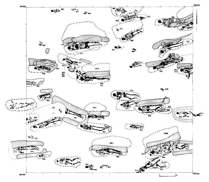
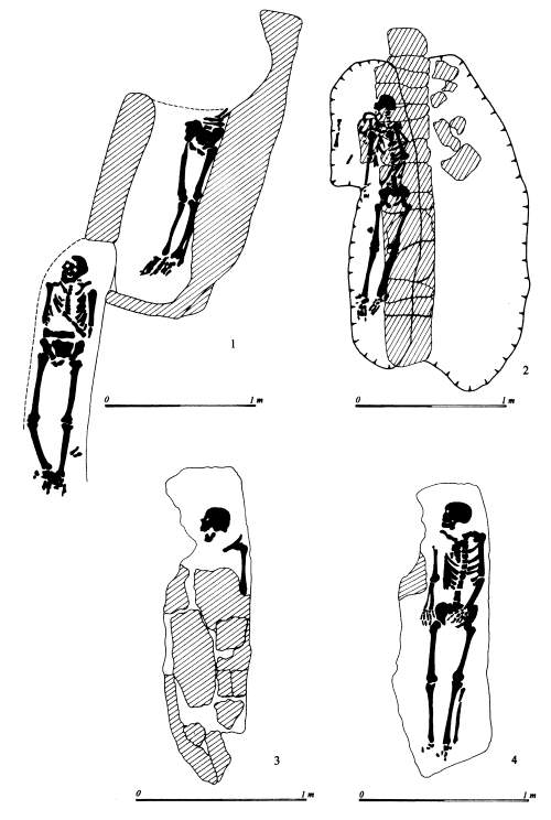
Byzantine cemetery (Figure 11, Figure 12). It was a large and intensively used burial graveyard. In total 59 complete burials have been discovered plus additional 12 clusters of human bones not in anatomical order (Table 1). The cemetery was constantly used for a number of years, probably longer than 100 years. The Byzantine people buried their dead in a complex and standardised way. The most striking is E-W alignment of all burials at this cemetery. A number of burial constructions accompanied the pits. Stratigraphic relations made possible to define their relative chronology. The oldest were the burials with a cut lined with mudbrick wall. There are 4 graves of this kind (features 856, 874, 941, and 942). The burial cut was relatively deep, rectangular in shape, with sharp top and base breaks. It was lined with one mudbrick wide wall around its circumference. The body was in extended and supine position, slightly on the right side with their heads facing west. Its back was always touching the northern edge of the burial pit. Its legs were either straight or slightly bent. It is difficult to specify whether and how this kind of burial was marked on the surface. It is possible that the wall were high enough to mark the grave.
Another category of burials, younger from the previous ones, were sophisticated structures comprising wall inside the burial cut with skeleton always from the southern side of the wall. This construction consisted of a large pit usually oval in shape and not very deep. On the base of this pit a massive wall was built which length corresponds exactly to the length of the pit itself. Once the pit was dug out and wall constructed a proper burial pit was dug out, always from the southern side of the wall. It was relatively deep, rectangular in shape with sharp top and base breaks. It was often built in the form of niche which part was underneath the wall itself. As a result, the whole burial looks in a profile as a construction with niche. The body was again in extended and supine, and on its right side. In total, 14 burials of that kind was discovered, and thus this makes the most common burial category at this cemetery (features 857, 890, 900, 903, 905, 908, 912, 914, 918, 922, 928, 934, 938, and 939). In one case (features 915 and 939) two skeletons were deposited in the same burial pit, one into the other and the later has not destroyed the younger one.
The third category is represented by only four features (features 947, 863, 902, and 906). It is younger from the categories described above. It is characterised by an oval and rectangular pit, in some cases difficult to define. Their infills contain destroyed mudbrick and stones. That indicates existence of difficult to specify burial construction, possibly a kind of lid or grave marker. Similarly to other categories, the body is in extended position with head facing west. It is also slightly on the right side. In once case (947) this kind of burial is dug out into older burial (912) and destroys it completely.
The fourth category comprises burials without any construction. It is represented by 12 cases (feature 851, 854, 855, 858, 865, 869, 870, 872, 909, 910, 913, and 945). The body is in extended and supine position with head facing west, or in one case (feature 913) which head facing south-west. The body was buried in rather shallow pit, sometimes burial cuts were not possible to distinguish. Interestingly, a large number of this kind of burials comprises skeletons of infants and juveniles (features 851, 855, 858, 869, 872, 870, 869, and 945). This kind of burial is younger than category 1 and 2 , however due to lack of stratigraphic relations it is impossible to define its relations to the third category of burials.
The last category of burial comprise clusters of human bones. They were found in three locations within the excavated area and particular bones were noticed at different layers. It appears as if the bones were taken from one location and then deposited in the other. They might have been taken during preparation of the younger burial. Due to lack of stratigraphic relations it is impossible to establish chronological position of the category of burials.
A number of other burial were also recovered which does not fit into categories distinguished above. They comprise different cases, namely two parallel cuts or burial in relation to the pit. It is possible that they belong to one of the above mentioned categories, however due to further destruction certain architectural elements might have been destroyed that makes its attribution difficult.
The works in the next season will be continued in the same trench and its major aim will be to discover and excavate a Neolithic house and to recognise two latest phases of the Neolithic occupation known as Levels I and II.
Figures
Figure 9: Plan of the site with localization of the TP area
Figure 10: Cross-sections of the TP2001 trench
Figure 11: TP 2001 - Plan of the Byzantine cemetery
Figure 12: TP 2001 - Examples of burial constructions
Figure 13: Later Roman house. 1 - mudbrick construction, 2 - clay construction, 3 - burned wooden constructions, 4 - ovens, 5 - after-fire layer, 6 - stones, 7 - reconstruction of house walls, 8 - elements of construction from after-fire phase
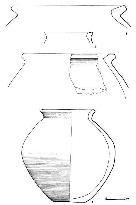
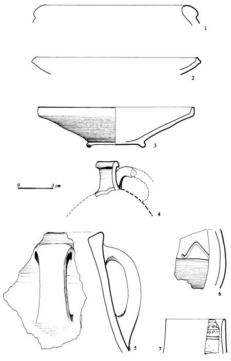
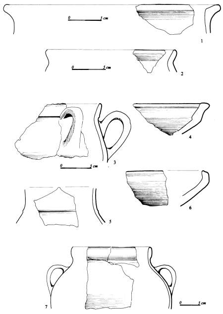
Figure 14: Late Roman/early Byzantine pottery: unit 6985 (1-2), unit 7093 (3), unit 7011 (4)
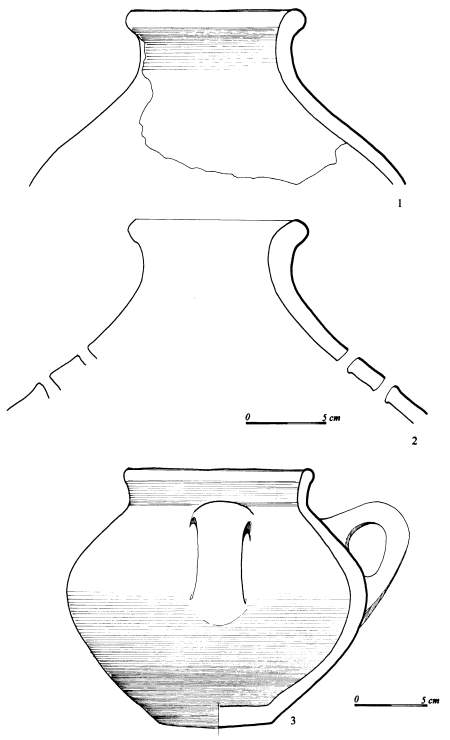
Figure 15: Late Roman/early Byzantine pottery: unit 7001 (1-2), unit 7093 (3)
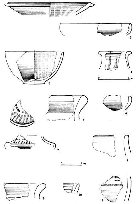
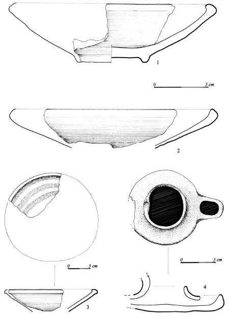
Figure 16: Late Roman/early Byzantine pottery: unit 7030 (1-3, 6-7), unit 7011 (4), unit 7001 (5)
Figure 17: Late Roman/early Byzantine pottery: unit 6988 (1-3), unit 7077 (4-11)
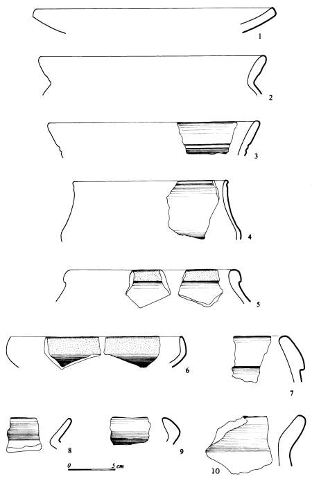
Figure 18: Late Roman/early Byzantine pottery: unit 7090 (1-6), unit 7093 (7), unit 7011 (8, 10), unit 7013 (9)
Figure 19: Late Roman/early Byzantine pottery: unit 7013 (1-2, 4-5), unit 7011 (3)
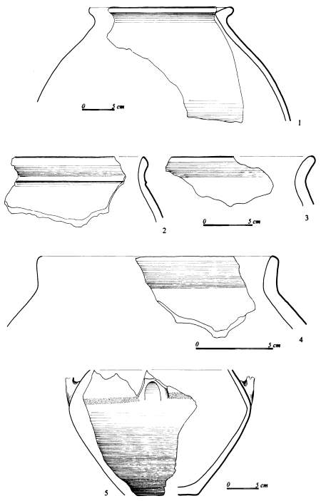
Figure 20: Late Roman/early Byzantine pottery: unit 7016 (1-2), unit 7077 (3-7)
Figure 21: Late Roman/early Byzantine pottery: unit 7093 (1-3), unit 6985 (4)
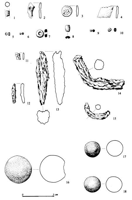
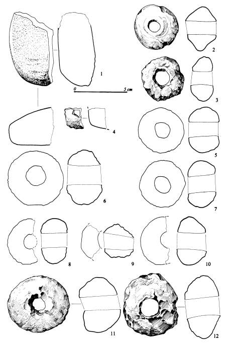
Figure 22: X-finds: unit 6776 (1 - fragment of clay figurine), unit 6817 (2 - fragment of bone item), unit 6919 (3 - coin), unit 6781 (4 - fragment of glass item), unit 7967 (5 - glass bead), unit 6738 (6 - glass bead), unit 6785 (7 - marble bead), unit 6761 (8 - turquoise bead), unit 7015 (9 - turquoise bead), unit 6813 (10 - turquoise bead), unit 6812 (11 - fragment of copper item), unit 6836 (12 - fragment of copper item), unit 6828 (13 - fragment of iron item), unit 6823 (14 - fragment of iron item, 17 - stone ball), unit 7041 (15 - fragment of iron item), unit 6763 (16 - stone ball), unit 6838 (18 - stone ball).
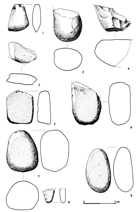
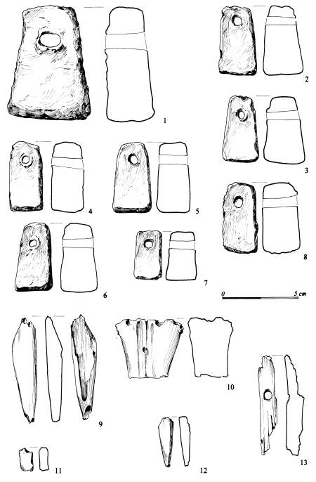
Figure 23: X-finds: unit 6729 (1 - stone axe), unit 6943 (2 - fragment of stone axe), unit 6937 (3 - fragment of stone axe), unit 6873 (4- fragment of polished stone, 6 - stone with partly polished surface), unit 6883 (5, 7 - stones with partly polished surface), unit 6849 (8 - stone with partly polished surface), unit 6960 (9 - stone with partly polished surface).
Figure 24: X-finds: unit 6702 (1 - fragment of polished stone), unit 6732 (2, 4 - clay spindle whorls), unit 6823 (3 - clay spindle whorl), unit 7093 (6-10 - spindle whorls?), unit 6849 (11 - loom weight), unit 6756 (loom weight).
Figure 25: X-finds: unit 6924 (1 - loom weight), unit 6985 (2-6, 8 - loom weights), unit 6948 (7 - loom weight, 10, 12 - bone tools), unit 6760 (9 - bone tool), unit 6823 (11 - bone tool), unit 6721 (13 - bone tool).
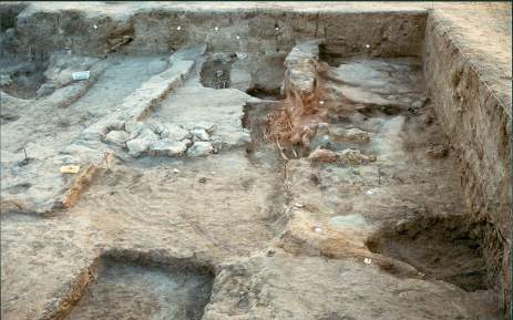
Figure 26: Northern part of the late Roman house and later Byzantine burials. A view from eastern side.
Tables
Table 1: Late Roman/early Byzantine burials
| |
© Çatalhöyük Research Project and individual authors, 2001