ÇATALHÖYÜK 2002 ARCHIVE REPORT
| |
The excavations of the TP (Team Poznań) Area in the 2002 season
2002 Kazý Mevsiminde TP (Team Poznań) Alanýndaki Kazýlar
Lech Czerniak, Arkadiusz Marciniak, Joanna Pyzel
Abstract
The archaeological expedition from Poznań, Poland, continued the excavation of a trench of 10 by 10 meters (TP Area), which is located in the highest point of the east mound. Work was undertaken between 15th of June and 16th of July 2002. As a result of this year season late Hellenistic and early Roman occupation of this part of the tell has been revised and clarified. Further discoveries revealed a layer containing a large amount of limestone fragments, which belongs to the earlier phase of occupation, probably Hellenistic in age. Other Hellenistic features comprised large and deep storage pits, which considerably destroyed earlier Neolithic deposits. All these structures are a proof of a long and complex late life history of the mound and show that it was an important element of the cultural landscape in early historical times. By the end of the 2002 season, we had discovered two Neolithic buildings and one wall, probably from phase I or II. Their exact layout and character remain unclear and the next season will focus on the excavation of these structures.
Özet
Poznań Polonya'dan gelen arkeoloji ekibi çalışmalarını 15 Haziran ile 16 Temmuz tarihleri arasında, doğu höyüğünün en üst noktasında yer alan 10 X 10 metrelik açmada (TP alanında) sürdürmüştür. Bu yılki çalışmalar sonucunda höyüğün bu kısmına denk gelen geç Helenistik ve erken Roma dönemleri yerleşmesine ait buluntular gözden geçirilerek belirginleştirilmiştir. Yeni buluntular yüksek miktarda kireçtaşı içeren ve yerleşmenin daha önceki dönemlerine, olasılıkla Helenistik döneme ait bir tabakayı ortaya çıkarmıştır. Diğer Helenistik dönem kalıntıları büyük ve derin depolama çukurlarından oluşmaktadır ki bunların daha eski Neolitik dönem kalıntılarını büyük oranda yok etmiş olduğu anlaşılmaktadır. Yerleşimin uzun ve karmaşık bir geç dönem tarihinin varlığını kanıtlayan bu yapılar, höyüğün erken tarihsel dönemlerin kültürel coğrafyasında önemli bir yere sahip olduğunu göstermektedir. 2002 sezonunun sonunda, olasılıkla I. ya da II. evreye ait olan iki Neolitik yapı ile bir duvar bulunmuştur. Tam planı ve karakteri kesinleşmemiş olan bu yapıların kazılması önümüzdeki sezonki çalışmaların amacını teşkil etmektedir.
Introduction
This year was the second season of excavation of a new area on the east mound called TP (Team Poznań). Work commenced on June 15, 2002 (one week later than our scheduled start date) and was completed on July 16, 2002. The team, made up of 10 archaeologists and students from the Institute of Archaeology and Ethnology, Polish Academy of Sciences in Poznań and Institute of Prehistory, the University of Poznań, continued the excavations in a trench 10 by 10 meters on top of the east mound and located next to an area excavated by James Mellaart in the 1960s (Fig.6).
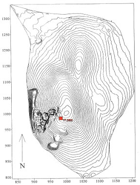
Figure 6: Plan of the site with localization of the TP area
The primary objective of the excavations that began last season was to study the last two phases of the Neolithic tell occupation, known as Catalhöyük I and II and dated to the end of the seventh millennium BC. The crest of the east mound was believed to be ideal for recognition of the late Neolithic structures. The decision to open up a trench in this particular part of the east mound was preceded by the work conducted by a team supervised by Shahina Farid in the 2000 season.
The first season has considerably improved our knowledge of the later use of the mound, which had already been recognized from surface work and excavations in the BACH and Summit areas. The late history of the tell turned out to be much more complex and longer than previously thought. The excavations revealed intense occupation dating back to the Roman period and comprising two phases separated by a destruction event. It had a form of storage buildings made of mudbrick along with pottery and spindle whorls production centers. These structures were destroyed by fire and abandoned. After the destruction some elements of the burned buildings were rebuilt, and new layers of mudbrick were put on top of the destroyed walls. After the buildings went out of use the area was used as a cemetery in the Byzantine Period. The relatively small area excavated contained a remarkable total of around sixty complete burials plus the remains of a number of other groups of disturbed human bone.
This year, the excavations started with clarifying and excavating the two late Hellenistic/early Roman buildings (Buildings 30 and 31) and one storage annex (Building 32) identified and partly excavated at the end of the previous season (Fig. 7). Buildings 30 and 31 were separated by a narrow passage. All these constructions appeared to have been used both for manufacture and storage of clay objects. The results of this year season brought about better understanding of the buildings location. They appeared to have been placed on a terrace cut from the east. As identified in 2001, the buildings were built, then burnt down, and then were rebuilt almost on the same place. A preliminary analysis of pottery indicated a date for their construction and use in the late Hellenistic and early Roman period.
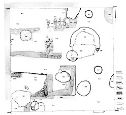
Figure 7.Hellenistic/early Roman buildings
Late Hellenistic/early Roman occupation phase
Building 30
Building 30 is located in NW part of the excavated area. Walls that comprise its eastern and western side have been clearly defined. They were made of mudbricks placed on the stone base. Well preserved bases of the house walls rendered recognition of the house construction possible. Interestingly enough, the western wall was situated directly below the edge of the excavated area and it is clearly visible in the western cross section. This year excavations revealed that the Building is smaller than previously predicted. Its northern part, which was previously regarded as an integral part of the building, turned out to be an area just outside the building, functionally related to it. The building comprised a large storage area and complex of kilns, located just outside its northern wall. Storage area dimensions are: 3.40m x 1.80m. Its northern part was relatively difficult to define as it was largely destroyed by later features, especially by burial cuts. A large cellar having about 1 metre diameter and 50 cm depth was located against its northern wall (it was partly underneath the wall and had a form of niche). A large number of pottery sherds and 39 spindle whorls were found there. Pottery included large storage vessels as well as fine table ware. An area just outside northern wall of the Building 30 was probably used for pottery and spindle whorls storage and manufacture. The circular kiln (Feature 966) was found very close to its northern wall (Fig. 8). It had a domed superstructure made up of many layers of clay. It is difficult to discern whether kiln was put up on the surface or dug out into it. The base of this kiln consisted of a number of thin layers. In this area we discovered a large number of storage vessels, spindle whorls, grinding stones, and an olive lamp. An array of four rectangular kilns, used for spindle whorl and pots production, was built against eastern part of the northern wall of Building 30 (Feature 991) (Fig. 9). They were a sectional superstructure made of a large interlinking mudbricks and a large rake-out area in front. All kilns were rectangular in shape with entrance from the north. Their walls were flat inside and convex outside and were made of a row of mudbricks and usually two or three layers of bricks were put one on the top of the other. All kilns, except for the most eastern one, had perforated base set on top of a relatively thick layer of burnt black and brown soil. All kilns had the following dimensions: 2.85m x 2.00m x 0.98m.
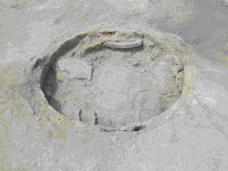
Figure 8: Circular kiln outside the northern wall of Building 30
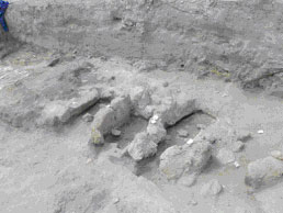
Figure 9: Rectangular kilns built against eastern part of the northern wall of Building 30
Building 31
Building 31 is located in SW part of the excavated area. It consisted of a storage area and was used as a storage place, which can be inferred on the basis of a large number of potsherd and grinding stones. This year excavation clarified the fact that previous suppositions regarding its construction were partly unjustified. What was previously interpreted as a living room with flat and well kept floor turned out to be a passage between Buildings 30 and 31. Northern wall of the Building 31 had a relatively light wooden construction. Its southern wall is difficult to define as it was considerably destroyed by later features. It probably had a small niche in its SW corner, but its southern wall is located outside of the excavated area. Storage area width is 3.40m and length within the trench 3.60m. One kiln (Feature 953) was found outside its southern wall, however, its relation to the Building 31 remains unclear. It was a circular kiln, probably with a domed superstructure made of many layers of clay. Unfortunately, due to considerable destruction by later cuts, its exact construction and character is difficult to specify. A small storage annex, recognized as Building 32, has been attached to the Building 31 from its eastern side. The Building 31 was later burned and some of its elements then rebuilt.
Building 32
Building 32 is located in south-central part of the excavated area, and it was constructed against the eastern side of the Building 31. It was used as a storage place. Its internal dimensions are: 1.80m x 1.85m. A deep storage pit (Feature 949) was found in its eastern part, however its relation to the building remains unclear. Both infill and cut of the feature were clearly distinguishable. The infill contained a large number of pottery, bones and obsidian. A small hearth (Feature 962) was found between the pit and western wall of the Building. It comprised two kinds of bedding - dark brown sand in its NE part and light brown sand in its SW part. The feature was destroyed considerably by different post-depositional processes and therefore its original size and shape are unknown. The Building has four walls (Feature 992) made of brown and brown-orange mudbricks. A state of preservation of this construction varies considerably. The best preserved are southern and eastern walls while the western one is highly visible. No clearly distinguishable mudbricks have been found in the northern part, however the consistency and colour of this unit is similar to layers in the other three walls. Therefore interpretation of this unit as a northern wall of the storage annex is not completely certain. Building 32 was destroyed by fire and later rebuilt and used for a considerably long period of time, the evidence of which is the presence of very thick deposits above the base of the wall.
Hellenistic occupation phase
A layer containing a large amount of limestone fragments was identified below these buildings. Its exact function remains unclear at this moment. We speculated that this might have been a paved area or the remains of walls. Most of these limestone fragments were cleared away by the builders of the Hellenistic/early Roman structures, but they survived in situ in some parts of the trench. Three major concentrations of stones have been discovered. The first one has a form of irregular rectangular and is 3.0m long and 1.2m wide. It is located in the southern part of the trench (Unit 7324), directly underneath the eastern part of Building 31, western wall and western part of Building 32. A vast majority of stones are small and irregular. Two large stones from eastern side are considerably polished as a result of trampling. The second cluster (Unit 7380) is located in south-central part of the trench and has the following dimensions: 1.9m x 1.0 m. It was made of small stones constructing a layer, probably a floor and had a regular rectangular shape. Remains of a second layer of stones were registered in a few instances. The third and the smaller concentration is located in north-central part (Unit 7369) (Fig 10), partly underneath a complex of four late Hellenistic/early Roman kilns (Feature 991), and has the following dimensions: 1.5m x 0.4m. It was a cluster of stones of different size, without any traces of being worked. Only one layer of stones has been found, however an overall size of the stones was larger than in Units 7324 and 7380. Interestingly enough, no stone layer was discovered in a narrow passage separating Buildings 30 and 31. This layer is certainly related to an earlier phase of tell occupation than the buildings above, albeit their exact date is not specified at this point.
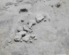
Figure 10: Fragment of stone layer located in central-northern part of the trench (Unit 7369)
The other common Hellenistic features in this part of the mound are storage pits. They were located almost in all parts of the trench. However, they are mainly concentrated in its northern and southern sections (e.g. Features 954, 980). These pits were regular and irregular oval in shape and had diameter varying from 0.60m to 1.20m. Both their cuts and infills were clearly distinguishable. In the majority of cases they were very deep which led to a considerable destruction of earlier Neolithic structures. It is not clear at all whether the stone layer described above is functionally and chronologically contemporaneous with the storage pits.
The largest pit is located in NE part of the excavated area. It had a difficult to specify wall/compact layer around the circumference of its cut. It was probably later reused. The late phase of its filling is associated with the dome oval oven as a lot of ash has been found in upper part of its infill. This oven has to be linked with the post-fire phase of occupation of the late Hellenistic/early Roman phase of occupation in this area of the mound. However, their mutual relations remain unclear, as it is difficult to establish to what extent they were contemporary. The excavation of the pit has not been completed yet, thus its coherent description is not possible at this moment.
Neolithic occupation phase
The last phase of occupation discovered this year comprised clearly defined walls of various small late Neolithic buildings (Building 33 and 34) in the western and central part of the excavated area (Fig. 11). All these constructions were considerably damaged by cuts of various features from all later phases of occupation in this part of the tell, especially by Hellenistic storage pits. This renders recognition of layout of the Neolithic structures as well as discerning relations between them very difficult. Not all the relations have been recognized so far and thus further excavations will be aiming at defining them in detail.
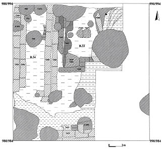
Figure 11: Plan of Buildings 33 and 34 and other features excavated in 2002
Building 33
Building 33 is a rectangular construction with a small niche in SW corner in which a rectangular oven was placed (Fig. 12) (Units 7439 and 7449). Since the feature has not been excavated yet, it is impossible to present here its complex and coherent description. Other features comprise two oval ovens in a central part of the building (Units 7465, 7466 and 7467) as well as a number of postholes (Features 986 and 989), which may not necessarily be contemporaneous with the building. They might have belonged to later structures that were built on top of this Neolithic construction. Cut and infill of the features were easy to distinguish. The walls of the building were made of gray mudbricks. An exact layout of the house is difficult to discern due to its considerable destruction by later Hellenistic pits. Eastern wall of the house, cut by a very deep storage pit, was particularly severely destroyed. Thus, it is not certain whether preserved eastern walls (Units 7438 and 7408) are in fact construction elements of the building. A large number of Neolithic pottery was found on the floor of the northern part of the building. Northern wall of the building has not been discovered so far. It may have existed outside the excavated area or might have been destroyed by later occupation. Internal dimensions of the building recognized within the trench are 2.25m x 1.0m.
Figure 12: A small niche in SW corner of Building 33
Building 34
Building 34 is a rectangular construction with a double brown mudbrick wall. It is situated along N-S axis. An exact length of the building is unknown as it stretches beyond the northern edge of the excavated area. The building was considerably destroyed by later site occupation. Its northern part is destroyed by later pits (Features 940, 971, 974 and 980) and burial (Feature 955), whereas the southern part by two pits (Features 961 and 983). The dimensions of the part of the building within the trench are: 3.6m x 1.6m. Its total surface including walls is 5.76 m2, while the interior has only 2.24 m2. The walls were made of brown mudbrick of different size. Small fragments of a red painted plaster (Fig. 13) associated with the building wall has already been found in its SE corner.
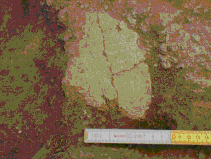
Figure 13: Fragment of painted plaster in SE corner of Building 34
A very solid double mudbrick wall was discovered along the southern edge of the excavated area (Units 7452 and 7453) (Fig. 14). It is located along E-W axis, parallel to southern edge of the trench. The wall is very well preserved and relatively high, at least one meter. Its layout was visible at the bottom of a large and deep Hellenistic pit located in this part of the trench (Feature 990). The wall certainly belongs to another Neolithic building. Since it was discovered at the very end of the 2002 season, no further details about its construction are available now.
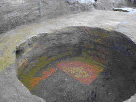
Figure 14: Neolithic wall in southern part of the trench
In addition to the structures presented above numerous Hellenistic, Chalcolithic and Neolithic artefacts have been found including pottery, obsidian tools, grinding stones, spindle whorls, loom weights, dices (Fig. 15). The abundant Neolithic (Fig. 16) and late pottery demonstrates a wide range of form and decoration. An anthropomorphic figurine (Fig. 17) was another interesting find. It was discovered a few a centimeters below the surface, outside NE corner of the trench.
Figure 15: One of the dice found during the 2002 season
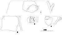
Figure 16: Selection of the Neolithic pottery
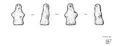
Figure 17: Anthropomorphic figurine
The works in the next season will be continued in the same trench and its major aim will be to revise and clarify the Neolithic buildings and their mutual relations in order to recognize the two latest phases of the Neolithic occupation known as Levels I and II. Additionally, it is planned to extent the trench westwards in order to link it with the easternmost trench excavated by James Mellaart in the 1960s.
| |
© Çatalhöyük Research Project and individual authors, 2002