ÇATALHÖYÜK 2003 ARCHIVE REPORT
    |
GEOMATICS
Duncan Lees
Abstract
The 2003 excavation season at Çatalhöyük saw the first appearance in the field of the Geomatics Team responsible for all aspects of site survey as well as spatial data processing and graphical presentation. Working with the existing project coordinate system the grid was extended within all the excavation areas currently under investigation on both the East and West Mounds. The team also undertook a programme of digitising during the season. The traditional hand-drawn plans produced by the archaeologists during the opening of the 4040 were processed and added to the digitally captured data to produce frequently up dated computer graphics of the archaeological deposits as they were being revealed. This enabled valuable checking and reinterpretation to be undertaken whilst the archaeologists were still working on site, greatly increasing the quality of the records.
A portable Cyrax® 2500 3D Laser Scanner was also used for the first time at the site and possibly the first on any archaeological site in Turkey. The scanning equipment was generously loaned by Cyra Technologies through their parent company Leica Geosystems and the professional geomatic experience was provided by Plowman Craven & Associates, UK. The system's optimal combination of accuracy-at-range, highly adjustable scan density, high scanning speed, adjustable field-of-view, and ease-of-use greatly enhanced the recording of the Neolithic buildings with a greater resolution.
Özet
Çatalhöyük’teki ilk saha çalismalarina 2003 kazi sezonunda baslayan Jeomatik takimi, höyük yüzeyindeki arastirmalarin tüm boyutlari ile mekansal verilerin islemlenmesi ve grafik sunumundan sorumludur. Varolan proje koordinat sistemi, hem dogu hem de bati höyügünde çalisma altinda bulunan tüm bölgelere yayginlastirilmistir. 40 x 40’lik alanda yapilan geleneksel el çizimi planlar, digital olarak elde edilen veriye eklenmis, böylelikle arkeolojik dolgularin kazildikça güncellenen bilgisayar grafikleri olusturulmustur. Bu çalisma, kayitlarin kalitesini son derece yükseltmis ve kazilan alanlarin kazilar sürerken kontrol edilebilmesi ve tekrar yorumlanabilmesini saglamistir.
Bir adet tasinabilir Cyrax® 2500 3D lazer tarayicisi, höyükte ve hatta belki Türkiye’de ilk kez kullanilmistir. Tarma ekipmani Cyra Technologies tarafindan, Leica Geosystems vasitasiyla ödünç verilmis, profesyonel jeomatik deneyimi Plowman Crave & Associates, UK tarafindan saglanmistir. Sistemin, dogruluk, ayarlanabilir tarama yogunlugu, yüksek tarama hizi, ayarlanabilir görüs alani ve kullanim kolayligi gibi özellikleri, Neolitik binalarin yüksek bir çözünürlükle kaydedilmesinde büyük ölçüde asama kaydedilmesine yol açmistir.
Introduction
The team consists of Duncan Lees (Team Leader) and Sophie Lamb from the Museum of London Archaeology Service (MoLAS), Dan Waterfall from PreConstruct Archaeology and Hüseyin Caner of Plowman Craven & Associates. The geomaticians supported all the excavation teams on site during the 2003 season, both on and off site, as well as commencing projects of their own.
The Seasons Work
Working with the existing project coordinate system Dan and Sophie extended the control network and set out grid points within all the excavation areas currently under investigation on both the East and West Mounds. A new excavation area designated the 40x40 was set out and grid points emplaced as the area was opened up. Furthermore, digital data capture of the cardinal archaeological features was undertaken as they were revealed using total station theodolites referenced to the project grid. The team also undertook a programme of digitising during the season. The traditional hand-drawn plans produced by the archaeologists during the opening of the 4040 were processed and added to the digitally captured data to produce frequently up dated computer graphics of the archaeological deposits as they were being revealed. This enabled valuable checking and reinterpretation to be undertaken whilst the archaeologists were still working on site, greatly increasing the quality of the records. Off site, Sophie also completed a number of artefact illustrations, display panel designs and produced plan data in DTP format for a variety of reports.
 |
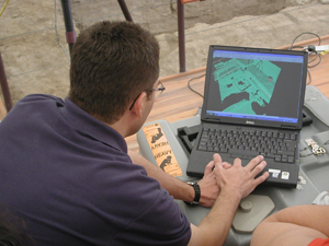 |
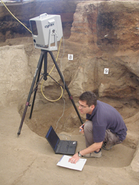
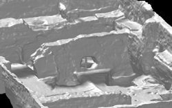
Figure 67: Laser Scanning Building 5
2003 saw the start of an ambitious programme of 3D data capture at Çatalhöyük by the Geomatics Team. Thanks to the generous support of Cyra Technologies and their parent company Leica Geosystems, the project was able to utilise a Cyrax® 2500 Laser Scanner to record some of the Neolithic structures revealed during the previous seasons’ fieldwork. The system optimally combines accuracy, scan density, a high scanning speed, adjustable field-of-view and ease of use. This equipment enabled the recording of the Neolithic buildings at Çatalhöyük in a way that has been impossible in the past. Hüseyin, Duncan and Dan scanned Building 5 (Fig. 67), and a significant portion of the structures in the South Area (See Fig. 38), collecting millions of sub-centimetrically accurate 3 dimensional points on the surfaces of the walls, floors and features within the Neolithic structures. These have been processed into rendered triangulated computer models that record the undulating, irregular surfaces of the structures extremely accurately (Fig. 69). This greater resolution will help to interpret the function and use patterns of the houses. The scanning equipment will ultimately enable the presentation of a 3D model of the Neolithic buildings and in future years of the settlement, permitting the viewer to move around and explore from any angle, perhaps from the views that the Neolithic people may have had themselves. Importantly, the scanned data is fully integrated with all the other spatial information at Çatalhöyük as it is referenced to the same project-wide coordinate system (Fig. 68).
 |
 |
Figure 68: Integrating scanned data to project wide coordinate system
 |
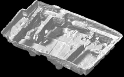 |
Figure 69: Rendered triangulated mesh of Building 5
Members of the Geomatics Team attended the CNR-ITABC workshop titled The reconstruction of archaeological landscapes through digital technologies in Rome during early November 2003 to present the preliminary results of the laser scanning programme at Çatalhöyük to a wider audience. Substantial press coverage was also garnered during the work in Turkey, with articles appearing in both local and national newspapers. It is hoped that the initiative can be developed further and that the Geomatics Team can expand upon all the work instigated during the 2003 season.
Acknowledgements
The Geomatics Team would especially like to thank the London-based staff of Cyprus Turkish Airlines, particularly Mr A Uluturk and Mr K Kenan who enabled us to get the laser scanner to Turkey with a minimum of fuss and expense. However, without the support of Plowman Craven & Associates the impact and scope of the work of the Geomatics Team would have been considerably reduced, so we are indebted to Simon Barnes and Derry Long for their interest and good humour in the face of adversity.
| |
© Çatalhöyük Research Project and individual authors, 2003