ÇATALHÖYÜK 2004 ARCHIVE REPORT
| |
Excavations of the 4040 Area
Spaces 226 and 243
Tatiana Stefanova & Predrag Dakić
Çatal core Team
Abstract
Between the 26th of June and the 5th of August 2004 we excavated an open area, which was defined during season 2003 and interpreted as a possible “street”. This space, 226, is defined by Building 47 to the north and Building 45 to the south in the area excavated in 2004 (see Fig 9). The aim of the seasons work was to identify whether Space 226 was ‘midden' area between structures or a possible ‘street'/alley way.The investigation revealed that Space 226 was in fact a large open space filled with midden deposits, sloping from north to south and from west to east and building up against the wall bordering it to the south (F.1458/F.1464). It is trapezoid in plan, its long axis being east-west oriented. Space 226 is ca. 10.5m long (east-west), its wider side is 6.6m in length west and its narrower side is ca. 2m in length east. The deposits in the north-western part of the space differ considerably from the ones in the eastern and the southern parts. They consist of light brown and brown layers of compact clay and ashy lenses, forming a solid, relatively “clean” layer, which was used either for levelling the terrain or as a consolidation base for the buildings to the north of the space. Only the topmost layers of these were excavated and micromorphological analyses will hopefully reveal whether this area was used as trodden surface. The midden deposits in the southern part of the space are the typical type of Neolithic midden – grey, dark grey to black layers of silty clay, organic materials, charcoal and ashy lenses, mixed with large number of animal bones, obsidian chips and tools, stones and pottery fragments. The space is bordered by walls: F.1458/F.1464 and F.1460 to the south, F.1463 to the west and F.1457/F.1465 to the north. These deposits extend beyond the limits of excavation to the west and east therefore a possible ‘street'/alley way could still be expected.
Özet
26 Haziran ve 5 Temmuz tarihleri arasında, 2003 yılında bulunan ve ‘sokak' diye tanımlanan açık alanı kazdık. Alan 226'nin kuzeyinde Bina 47 ve güneyinde Bina 45, 2004 sezonunda kazılmıştır. Bu sezondaki ana soru, Alan 226'nın yapılar arasında bir çöplük dolgusumu yoksa muhtemel bir sokak, yol olup olmadığı sorusu idi. Araştırmanın sonunda Alan 226'nın aslında kuzeyden güneye meyil gösteren ve batıdan doğuya doğru güney duvarının dibinde biriken bir çöplük dolgusu olduğu ortaya çıkmıştır (F.1458/F.1464). Plan üzerinde bir yamuk şeklinde olup, uzun ekseni doğu-batı doğrultuludur. Alan 226'nın 10.5m uzunluğunda (doğu-batı), geniş ekseni 6.60m (batı) genişliğinde ve 2m genişliğindedir (doğu). Kuzey-batı doğrultusundaki dolgu, çok açık bir şekilde doğu ve güney kısımlarından farklılık gösterir.Alan, düz seviyeye çıkarma veya alanın kuzeyindeki binaların yapımı için temel oluşturmak için düzenlenmiş olan açık kahverengi ve kahverengi renkte birbirinin içine geçmiş kil ve kül tabakalrından oluşur. Bu alanın en üst seviyeleri kazılmıştır ve burasının ayakla basılmış bir alan olup pladığı mikromorfolojik analizler sonucu ortaya çıkacaktır. Alanın güneyindeki çöplük dolgusu ise tipik Neolitik tipi bir çöplük dolgusudur-gri, koyu griden siyaha doğru değişen ince bir kilden, organik malzemeden, kömür parçalarından, kül tabakalarından, hayvan kemiklerinden, obsidyen parçalarından ve aletlerinden, taşlardan ve çanak-çömlek parçalrından. Alan duvarlarla çevrilidir: güneyde F.1458/F.1464 ve F.1460, batıda F.1463 ve kuzeyde F.1457/F.1465. Bu tabakalar kazı alanının sınırlarını doğu ve batıda aşmakta dolayısıyla halen muhtemel bir ‘sokak'/yol yapısı gelecekte ortaya çıkabilme olasılığını korumaktadır.
Space 226
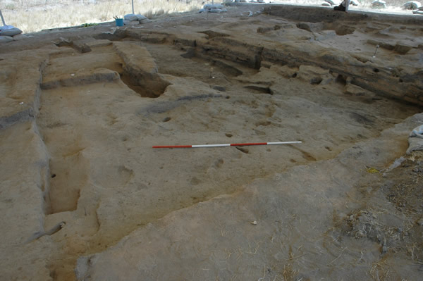
Figure 34: Space 226 ‘midden' built up against walls along the top of the image, compacted debris in the foreground and Space 243 top left corner. Looking E.
It seems that Space 226 was part of a larger open space midden area (?), which was gradually overbuilt during the later levels of the sequence at Çatalhöyük Level V or even later and what we excavated during 2004 was a small ‘midden' island between the inhabited areas and tight groups of buildings (Fig 34). Space 226 was apparently an area where inhabitants deposited their house rubbish but also a place where other type of activities have taken place. There is an open fire place and two large pits dug into the midden in order to extract material for secondary use. The gradual accumulation of the midden increased pressure on the walls of the standing buildings, walls F.1458/1464 and F.1416 and the need for consolidating them arose several times as it appears. These building events provide a nice example how the Neolithic people managed some of the constructional problems. The earliest supporting wall F.1464 was erected in the southwest corner of Space 226 it extends westwards and part of it was excavated. Four courses of light brown sandy bricks are preserved up to a height of 0.47 m. Since a small part of this wall was revealed, we are not able to define whether it was a real consolidation wall or a part of a building group. Later on, wall F.1464 was overbuilt and extended to the east by another wall F.1458, which is the main border wall of Space 226 as excavated, and which was obviously build ad hoc judging by its irregularity. It consists of 6 courses of brown crumbly bricks laid on the midden deposits in a stepped pattern following the slope of terrain west-east direction; the exposed part it also extends, both east and westwards) is 10.5 m long, 0.40 m wide and it is preserved up to a height of 0.60-70m. Both F.1458 and F.1464 are further supported to the north by another “wall” made of hardly discernible courses yellow silty clay and ashy mortar, resembling construction rubble more than a regular wall. Finally, the least exposed wall F.1460 abuts F.1458 in its eastern part and extends eastwards to the unexcavated area.
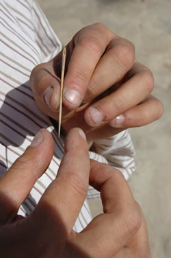
As for the existence of a possible ‘street'/alley way, running east-west alongside all these walls there is no reliable evidence so far no compact layers or traces of trampling. Micromorphology samples were taken from the bottom layers of the western section of Space 226 which showed possible compaction and will be examined for traces of trampling. Space 226 is bordered to the west by a wall F.1463, which is visible in the section but it has not been excavated. Bricks laid sideways are seen in plan. A wall F.1457 encloses sp. 226 to the north in the later stages of its existence. The lithics and pottery indicate a mixed assemblage, possibly contemporary or later than Level V although later Late Neolithic and Chalcolithic sherds were also found. The midden yielded four clay stamp seals (see Figs. 86, 88 & 89), two fine bone needles (Fig. 35), one crude, fragmented figurine representing bull's head and a number of other small finds.
Space. 243 |
Figure 35: Fine bone needle |
Space 243 was revealed in the north-eastern quadrant of our area, protruding into Space 226. It is rectangular in plan, ca. 2.6m long east-west and 1.9m wide north-south. The space was not excavated and its relation to Space 226 remains uncertain. It is enclosed by the following walls: F.1453 to the south, double wall F.1454 to the west and F.1461 to the east. We are not certain about the northern wall, as F.1462, which borders Space 243 seems to be a later one bricks are laid sideways than in other walls and probably in relation with later structures to the north. Therefore it is possible that Space 243 extends further north. Plastered features of this space are seen in the northern section provided by the cut of a burial F.1455. It is possible that F.1453 is a double wall also. It consists of southern and northern parts/walls. The southern wall is narrower, irregular and shallow lies on midden and probably later The northern one is definitely related to Space 243 and its northern face is plastered. Relations between the walls of Space 243 are not very well defined due to erosion and later truncations.
East of Space 243 lies an unexcavated area. From the surface scrape it appears to be paved with mudbricks resembling the ones in wall F.1462. Similar surface was detected in the eastern extent of the area to the south of wall F.1458.
Late Roman/Early Byzantine burials and other cuts
Five Late Roman/Early Byzantine burials were cut into Spaces 226 and 243. These are features F.1450, F.1451, F.1452, F.1455 and F.1456. Not all cuts were easy to trace , for example we were not able to define a cut for F.1451 at all, because of erosion and due to fact that most of them except for burial F.1450 were cut into midden and filled backfilled with the same deposit. All skeletons were in laid in rectangular cuts, dorsally extended, with their heads to the west. All of them were in poor state of preservation due to their close position to the surface. Only one burial F.1450, yielded a grave good, a copper/bronze needle found on the right part of the chest of the skeleton. Grave structures existed for F.1450 and F.1452. The bottom of the cut of the former was lined with tiles, with a single tile also used as a head stone and the latter was lined by mudbricks which also contained false bottom. Some of the burials contained iron nails and traces of wood but no reliable evidence of wooden coffins was detected.
The burial fill of F.1450 yielded a residual Neolithic obsidian mirror, the first one found by the current team.
| |
© Çatalhöyük Research Project and individual authors, 2004