ÇATALHÖYÜK 2004 ARCHIVE REPORT
| |
CULTURAL AND ENVIRONMENTAL MATERIALS REPORTS
Ground Stone Report
Adnan Baysal
University of Liverpool
Abstract
This report aims to describe the studies conducted on the ground stone material of Çatalhöyük in the season of 2004. The studies of ground stones can be grouped in two categories. Processing finds on site which are discovered during the excavations. Continuation of the Geographical surveys in order to define the raw material sources from which ground stone artefacts produced. Both these categories of the study aim to understand the ground stone assemblage of the site and identification of the raw material sources of the tools that have been produced. The conducted study on the ground stone assemblages and sources were useful not only for Çatalhöyük research project but also for the understanding of the Central Anatolian ground stone assemblages and their raw material sources.
Özet
Bu rapor‚ Çatalhöyük öğütme taşları üzerinde 2004 yılı kazı sezonunda yapılan çalışmaları tanıtmayı amaçlamaktadır. Bu çalışmalar iki grupta toplanabilir.
• Kazılar sonucu elde edilen malzemenin kazı sezonu içinde değerlendirilmesi
• 1998 yılında birincisi gerçekleştirilen hammadde kaynaklarının araştırılması
Bu her iki kategori içinde sürdürülen çalışmanın amaçları kısaca, Çatalhöyük öğütme taşlarının hakkında detaylı bilgilerin toplanması ve bu taş aletlerin yapılmış oldukları hammadde kaynaklarının tespiti olarak özetlenebilir. Her iki kategoride gerçekleştirilen çalışma sadece‚Çatalhöyük için değil aynı zamanda orta Anadolu öğütme taşlarının da daha iyi anlaşılmasında ve kullanılan kaynakların tespiti ve bu yolla yerleşmeler arası olası ilişkilerin anlaşılmasında yararlı olacağı kesindir.
Introduction
The studies of ground stones of Çatalhöyük started to reveal some specific information on several areas. These areas, as it was stated in our last report (Baysal and Wright 2002; and Baysal and Wright in press), have a wide spectrum which ranges from ethnography, trade, tool technology, food production, dietary habits, household activities to development of tool typology through time.
The Work of the 2004 Season
The work on ground stone material at Çatalhöyük in season 2004 concentrated on the following areas.
• Konya Plain Survey ground stone material
• West Mound Material
• Bach Area material
• Continuation of Geological sampling
The ground stones that were found during the Konya plain survey have been processed completely. This aspect of the work will provide an insight into the ground stone assemblages through time in the Konya plain. The sites have been found and revisited during the survey work in the Konya plain and are dated on the basis of ceramic and other artefact types that were collected from the surface of these sites. The study of these artefacts produces a range of dates which spans from the Neolithic to today. These sites and artefacts are currently studied in detail in order to contribute to understanding the archaeology of the Konya plain.
The other groups of artefacts from the BACH area (North of Çatalhöyük East Mound) and West Mound have been studied as priority groups. These areas have been excavated in the last years and now the works of these areas are being prepared for publication. The ground stone artefacts that have been found during the excavations in these areas were prioritised in this season and the artefacts from the given priority units from both areas were successfully completed. Two different areas, the Bach Area in the north part of the East mound and the west mound which is Chalcolithic period, will provide us with the continuation of typological development through time of ground stone assemblages on the site. This research with the addition of the Konya plain survey ground stone artefacts can also reveal the possible changes and the new addition to tool types as well as disappearances of specific tools or types. This will highlight the technological changes in the tool production, use or change of raw material source and through time evaluation of the artefacts.
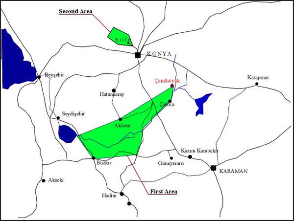
Figure 99: Region of Sille
Mellaart's excavations concluded that‚Çatalhöyük had long distance trade relations. The shell beads, which originate in the Mediterranean, can be shown as the best example to explain this network. The current obsidian studies indicate that obsidian based trade from central Anatolia also reached to Syria (Balkan-Atlı and et al 1999). These evidences support Çatalhöyük as interactive in relations to the south and southeast distances.
This season, skeletal remains were discovered during the excavations in the South Area. The significance of these remains was that the skull had been plastered. This may be evidence to suggest that Çatalhöyük was not only trading or dominating the trade to south-eastern part of Anatolia but also interacting with the cultures in this direction (Verhoeven 2002).
However, Mellaart's excavations did not provide strong evidence in order to support Çatalhöyük's Western connections. The only suggestive evidence can be found in ceramic typology. The rectangular forms seem like a table, which can be found in Level III. These forms are new and appear for the first time in the upper levels and these forms seem very similar to Balkan types. Although this is weak evidence it can be interpreted as a possible development of cultural interactions to the west.
Until this season possibly ceramic typology was the only suggestive evidence of this western relation of the site. However, found last year but not analysed until this year, is an item covered with ochre and is possibly a natural formation or a fossil but the raw material is Meerschaum (Fig. 100). The only source of this raw material in Turkey is nearby Eskişehir, which is almost 6 hours drive to the NW of the site. Meerschaum is another raw material type that was never listed or mentioned by Mellaart.
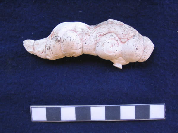
Figure 100: Natural formation or a fossil The meerschaum object and remains of ochre on its surface.
Simply, this indicates that research on raw material sources of ‚Çatalhöyük should also be widened into these regions rather than being limited Konya Plain borders. The result of raw material research will contribute to the understanding of cultural interactions and trade networks of the site.
Geological Sampling and Surveys
The first geological sampling work was conducted with the team of geologists from METU in 1998. This season, in the light of the results of first geological sampling (Türkmenoğlu, Baysal, Toprak and Göncıoğlu 2001 and in press), concentration on raw material source definition of ground stone assemblages of ‚Çatalhöyük, continued in wider area to the south of the site (Fig. 99).
First Area . The First Geological Sampling in 2004
The first geological sampling within the season of 2004 took place with a team of specialists from the site. The visit was organised on the 24th of July in 2004. The aim was the collection of samples in order to correlate the information with the data yielded by excavations.
The Groundstone perspective was as follows;
a) understanding of the raw material movement through the Çarşamba river
b) limestone sources ( Mellaart identifies a variety of limestone's which are ranged by their colour)
c) Possible collection of raw material for experiments
d) Increase sample collection from possible sources and archive samples.
e) Greenstone sources; then again according to Mellaart these stones can be found easily everywhere.
With these simple questions in mind, various areas at the foothills of the Taurus Mountains were visited, starting at Çumra's Gökhhöyük village.
The limestone formation next to the village of Gökhhöyük was fascinating as it has been quarried on its west side. The name of this limestone mass was Obruk Dağı which is at a height of 1171 m. The layers of limestone mass were easily seen in the sections of the lake. Samples were obtained from this formation. These were mainly cream coloured limestone, which is very compact and hard.
Limestone Quarry in Gökhhöyük village.
The next stop was Balcikhisar. This village was visited in 1998 in order to obtain stone samples while tracing the river bed. In fact, the samples were obtained from the river bed in order to see the rock types that accumulate in the Çarşamba river. The samples taken in 1998 were from the river bed in this village.
In order to provide some ideas about the house abandonment a mud brick house within the village was photographed and some details were recorded. The house is structurally very similar to ‚Çatalhöyük houses. Beside the village is a bridge which, according to a villager, was built by Germans at the time of Abdulhamit. The stones used for this bridge indicate that a medieval or earlier structure was nearby. Some of the stones have a rectangular form and one has been identified with an inscription .
The next village was Doğanli. In this village no samples were collected from the ground stone subject point of view. Following this village the team followed the route over the Dineksaray village to Dinek and stopped for a breakfast at the junction of Kurukavak and Dinek. The brunch was enjoyed and plant samples and some more limestones were collected from this spot.
After brunch, returned back to where the deposits of the Çarşamba river have been quarried for gravel. The reason for revisiting the deposits of the Çarşamba river was understanding the kind of material that the river brought to the site. Various types of rock have been sampled from this still open quarry. These deposits were also visited in 1998 and one of the reasons was to establish the green stone gravel size and their suitability in the production of celts/axe.
On the way, Dinek village was one of our visiting areas which was a green stone source. The green stone was massively available in the fields of Dinek village.
Arpasaraycik village was passed by and we arrived to Belkuyu. This was situated on the hillslope. From this village onwards architecture and landscape was dramatically different. For example, the use of mudbrick is replaced by stone and very old beams and roof supports but still the flat roof tradition continued. The limestone ranges also changed colour to grey as Mellaart mentioned in his reports. This area could be the source of the grey limestones that have been discovered on site.
Following that village we moved on to Alan and pass by the Alan village and headed towards Avdan. On the way to Avdan, samples were collected from a small flat spot where people do agriculture. In this area, a rectangular small structure, could be for animals or for peoples use during their field work had interesting aspects. The grey limestone mass extended here but in the near vicinity also marble and fine sandstone raw material was found. Closer to Avdan, a schist formation was spotted on the left side of the road. Down below the Avdan village the Çarşamba river was photographed and finally the team had a break at the bridge just before crossing the river towards Bozkir. Bozkir is a small town with a population of ten thousand people.
Following the main route to Suğla Basin we reached Yalöhöyük. Via Akkise, we advanced to Akören. On the way to Akören the landscape again changed and volcanic rocks were visible on each side of the road. Through Akören, via Alibeyhöyük we returned to Çumra and the site.
Second Area . The Second Geological Sampling in 2004
The Survey of Sille (Supported by the University of Liverpool PG student grant)
The region of Sille seems very flat and a continuation of the Konya Plain. However, as the road takes you to the town centre the background of the town gets hilly and more dramatic. The change in landscape is surprising. The old name of the town was Sillion, and its history goes back to the Roman period, and possibly earlier. The road into the town follows the river course. The town was occupied reasonably well in the past as it is today. The stream runs all the way through the town from the modern dam which is located at the back of the village.
The Church
The church of Sille, Hagia Eleni, has a very similar interior to its contemporaries. The continuous use of the church as a religious context even continued during the Ottoman period. The ÔminberÕ inside the structure indicates that the structure was also serving for Islamic religion as a mosque. The interior of the structure still has intact plaster and paint but they are badly preserved and the colour theme of the painting is getting lost.
Hand Crafts
The discovery of a ceramic shop and stone masonry which are still actively practised crafts, is one of the most interesting ties of the town with its past. The economy of the town is still based on the stone sourcing, and the town itself is completely built from it and has made vast use of the stone raw material. On the basis of A. Türkcan personal comment there is a large ceramic workshop which still provides the clay and its products to different areas in Turkey. The vast majority of ceramic sherds in the town are green glazed which suggests that this area may have been used as a clay source and that there was a high quantity production of ceramics from this town. This may bring into mind this simple question: was this town a source for the prehistoric production too?
Geology of the Region
The geology of the town is mainly volcanic. On the basis of surface material the general impression is of the availability of two types of igneous rock; the grey coloured volcanic rock and the pinkish coloured mass material which is famed as Sille stone. Both of these rock types have different varieties and degrees of softness.
Sources
The sources of stone in central Anatolia and the surrounding vicinity was very important in the past as it is today. The still open stone quarries and economic network keeps this town as one of the major suppliers of the famous Sille Taşı. Sille Taşı was used in the past for quern stones and has been used for grinding and distributed for long distances. Until 50 years ago even in Küçükköy villagers were heavily using the querns made from Sille Taşı. Today this stone is used for various purposes from structures to decorative purposes.
Samples
The samples that were collected are mainly from the town centre and just behind the village.
The Reasons for Sampling
The reasons for the geological sampling of the area are based on possible changes that may have taken place in the past in the sources of ground stone assemblages in Konya Plain. Therefore, if this change occurred the samples from this area will make it clear when this source started to be used in the past.
Analysis of the Samples
The analysis of the samples will be done at METU. On the basis of this analysis expectations are that the provisional opinions on the material sources and source related social and economical implications may be verified.
| |
© Çatalhöyük Research Project and individual authors, 2004