ÇATALHÖYÜK 2005 ARCHIVE REPORT
| |
Excavations of the IST Area
Mihriban Özbaşaran
Field Supervisors: Mihriban Özbaşaran, Güneş Duru
Site Assistants: Heval Bozbay, Turhan Ülgür, Nejla Kurt, Filiz Şeker
Abstract
The aim of Team IST focuses on the investigation of the earliest levels at Çatalhöyük. The area chosen for this objective was the southwest slope of the mound. In 2005 an area of more than 300 sq m was scraped; buildings, open spaces, kerpiç pavements (?), kerpiç walls, and a midden area(?) were documented and planned, and excavations were carried out mainly around a burnt building Space 252. The area as a whole is dated to Level IV/V by the pottery and the chipped stone.
Özet
IST Ekibinin Çatalhöyük’teki çalışmalarının ana amaçlarından biri yerleşmenin erken tabakalarını araştırmaktır. Bu hedef doğrultusunda höyüğün güneybatı yamacı çalışma alanı olarak seçilmiştir. 2005 yılı çalışmalarında 300 m2 yi aşan bir alan bu amaçla yüzey toprağı atılarak, sıyrılmıştır. Tüm/tüme yakın binalar, bina arası açık alanlar, geçitler, kerpiç döşeme ve duvarlar, olası bir çöp alanı, sıyırma neticesinde ortaya çıkarılan yapı ve yapı öğelerini oluşturur. Kazı çalışmaları 252 no ile adlandırılan yanmış yapı ve çevresinde yürütülmüştür. Çanak çömlek ve yontma taş laboratuvarı uzmanları tarafından çalışılan alan ilk gözlemler doğrultusunda Çatalhöyüğün 4/5.tabakalarına tarihlendirilmektedir.
IST Area
Fieldwork in the IST Area started on July 7th and ended on August 3rd 2005 with an average of six archaeologists and students and seven local workers. Due to the objectives of the work of Team IST, the area south of the South Area shelter was intentionally chosen for two main reasons: the slope and the proximity to the South Area. The idea and the ideal of excavating the earlier levels in wide areas pushed us to work on the slope, where in general, it is suitable to apply various excavation methods to reach the lower layers. The work of the present team on the other hand had also confirmed the existence of the earliest levels on this part of the mound. Therefore, if we could reach the early levels and expose substantial architectural remains in the newly excavated area, it would be possible to establish a good stratigraphy in relation to the South Area.
So, scraping started ca. 20/25 m south of the South Area (Fig. 68). At about 0.1m below the surface soil (1007.775m) architectural features started to appear (eg. a kerpiç wall, F.1950) (Fig. 69). Work continued towards the south, east and west where a complete building (Space 251), kerpiç walls, possibly a large platform - paved with kerpiç blocks - were exposed. Space 251 is located in the middle of the scraped area, lying in a NE-SW direction. Although the building was cross-cut because of the slope, it presented a quite complete plan. The building measured ca. 4.5 x 5.5m; identifiable kerpiç blocks measured 0.35 x 0.72 / 0.88 x 80mm. There is a projection on its inner east wall, which could be an internal dividing wall, and a possible platform in its southeast corner. The floor of a fire installation was exposed in the middle of the southern half making up the preserved inner architectural elements. The floor of the building was very close to the surface and its fill was almost totally mixed with later disturbances. Scraping continued by extending the area more to the east. The state of preservation was better in this area, moreover the room fills seemed thicker and more intact when compared to the northern area and also there was a burnt area. These reasons motivated us to put our test trench in this location.
Excavations
Besides the burnt building (Space 252), the area chosen for excavation displayed an open space (E of Space 252), which could be related to the building. Moreover, the position of the walls implied two different levels. A difference in the kerpiç between the northern examples with that of the south (in size and colour) signalled the possible existence of superimposing levels tempting us to start digging in this area.
Space 252
Space 252 is a kerpiç building, lying in NE-SW direction (Fig. 69). It is partially exposed; its east and north walls are in the unexcavated area. It is also a partially preserved building in that the south wall was destroyed by late pits and disturbances and the building itself by a fire.
The already exposed part of the building has a partition wall (F.1964) in the north. The wall itself was destroyed in the middle. The wall (its east face) once had nice fine white plaster, renewed at least four times. However, the state of preservation was very poor. A small clay box (F.1980) with its well preserved exterior plaster lies in the south part, adjacent to the east face of the wall.
In the south part of the room, south of the partition wall, lay two bins (F.1967 on the west, F.1984 on the east) and a destroyed (by two late pits) fire installation east of the eastern bin. The bins are roughly rectangular in plan (both are app. 0.4 x 0.3m) bordered by thin and fragile plasters. While one of them (F.1967) had abundant amounts of carbonized barley the other one did not present any significant remains/seeds.
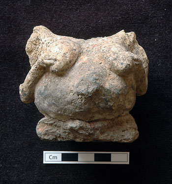
It seems that the building was partially burnt. It includes many fragments of kerpiç/mud plaster, most probably used in the roof construction. Burnt, negative impressions of reeds and/or branches were found often especially in the southern part of the building at different elevations. A collapsed kerpiç wall (F.1965) with nine courses of blocks was exposed in the eastern half of the room. However its original location and its stratigraphy need to be reconsidered next season. Various finds on the other hand came from the fill just above the floor level, at around 1005.8m. One of the most interesting finds of the building is a clay female figurine (12401.x7) with her head missing (Fig. 4 & 70). She seems to be pregnant on the front with an exaggerated belly. Her back on the other hand represents her skeleton. While her vertebrae, scapula and probably pelvis (?) were shown in relief and by incision, the ribs were only incised. It was found close to the west wall of the building, in the burnt fill, ca 0.3m above the floor level. Other finds in the same area include worked stones, polishing stones, ground stones, a shaft straightener (?) and a finely worked mace-head (?) made of limestone.
Their positions in general do not indicate their original position/location. When the building is excavated as a whole next season it is hoped that the inner structures and the architectural elements will be better understood and the position of the finds will be better interpreted.
Space 253
Space 253 is the most southern building so far exposed in the scraped area (Fig.69). Although the general characteristics, the location and the orientation look similar and in accordance to the above mentioned structures some differences were recognised in the size and the colour of the kerpiç used. Such differences tempted us to include the building in our excavation area and compare it to Spaces 252 and 251.
The first results showed that the building was cross-cut by the slope down to its floor level (at 1005.45m, the floor appeared in the northeast corner) and cut on its west by the village road. Therefore it did not yield any intact fill at all which hindered dating the building on the basis of the archaeological material. It was truncated on its northeast by intrusive late pits where its stratigraphical relation to Space 252 was blocked. Therefore the stratigraphical and/or the chronological position of the building remain unsolved and need further investigation. .
The importance of this partially preserved building is that it is the most southwest building excavated on the mound which proves that the settlement extends beyond the modern limits of the mound. It continues beyond the fences, probably on the other side of the road (Fig.68).
Open space
The fill of the area east of Space 253 had a non-domestic character. No architectural features were found. While

the uppermost layers (11855, 11859) gave the impression of eroded soil in prehistoric times, the lower layers (11874) seemed to be the open area in relation to Space 253. A cluster of 21 clay balls (11861) found in this area was most probably related with Space 253.
Conclusive remarks
The preliminary results of the work in Area IST can be summarised as:
-
The southwest slope of the mound was densely inhabited by terracing.
-
The southwest limit of the settlement continues further to the southwest, beyond the present village road/fences indicating that the settlement was much larger.
-
The excavated area can provisionally and relatively be dated to a settlement phase later than Level VI.
Figure 70. Female figurine (12401.x7) found in fill of Space 252, close to the floor horizon. |
Acknowledgements
We are grateful to Coca Cola Company - Istanbul, Konya Ticaret Odası, Kosiad, Konya Valiliği and Çumra Kaymakamlığı for their interest and support to our work at Çatalhöyük 2005.
| |
© Çatalhöyük Research Project and individual authors, 2005