![]()
![]()
![]()
REGIONAL SITE SURVEY
by Douglas Baird
Çatalhöyük has long dominated our view of the archaeology of the Konya plain. The survey in the region around the site is attempting to put the site in its contemporary and historical context. If we are to understand the site as some sort of centre then we must gain some knowledge of putative subsidiary or dependent settlements. If we can assert with confidence that no such settlements exist then we will require a different view of Çatalhöyük. In addition we would like to know more about the antecedents of Çatalhöyük and those developments that immediately follow the decline of this particular community on the plain. Only intensive survey can reveal the necessary information about any sites that may be relevant to these issues. The survey will also address questions that relate to long-term environmental impact and interaction. Questions include 'Did agricultural societies emerge in alluvial settings or on the hilly flanks of these plains?', 'How dense was settlement in different periods?', and 'What sort of settlement systems existed under regional and imperial states from the Hittites to the Ottomans?'
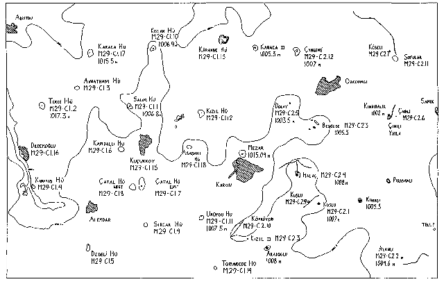
The density of sites in the area has been appreciated for some time. The first full season of survey in August-September 1995 has confirmed this potential and in particular our ability to recover the component of settlement buried under the alluvium of the plain. In an area, 12x10 kms, to the NE of Çatalhöyük in which we worked, 15 tell sites were indicated on topographic maps, only three the subject of previous, brief visits. By walking irrigation canals and areas adjacent to known sites, in only a small part of this area, a further 5 buried or non-tell sites, not shown on the topographic map, were located. A site density of 1 site per 6km² is indicated for such areas of the plain as a bare minimum. The value of walking the irrigation canals to locate buried sites has been demonstrated. This is particularly important for revealing earlier, prehistoric sites, some that may be contemporary with Çatalhöyük.
The creation of a detailed contour plan, and record of the distribution of artifacts across the site, the result of systematic and intensive sampling, has informed us about the presence and size of the different occupation episodes on each site, including the presence of prehistoric settlements masked by later occupation. Thus every iron Age-Byzantine site inspected in this year's survey had a buried prehistoric component. There can be quite radical differences in settlement size at different periods of occupation of individual sites. We have large Early Bronze sites with small Iron Age components, for example. We have also been able to document the growth of some sites through time. In particular, a number of sites started out as smaller Iron Age or Hellenistic settlements and then expanded considerably in the Roman or Byzantine periods. We can distinguish the special role of some sites. A low, unusually square, Iron Age site may be a small fort. The presence of human bone, slag, architectural elements and tiles allowed us to distinguish distinct components on some sites.
Agricultural intensification is destroying sites on the plain at an unprecedented rate. Our survey may be the only record of these sites in future years. In addition we are able to identify sites most under threat. Our Turkish hosts appreciate this information and may act upon it.
We will continue development of the project for the remote sensing of sites using satellite imagery. Since we have now located sites not on the topographic maps, including partially buried and non-tell sites, a study of satellite imagery may reveal diagnostic criteria for these sites. We can test these criteria by checking for sites, putatively identified from satellite imagery, in the field in the 1996 season. Subsequently we will be able to apply this method to other settings in the plain, in Turkey, and possibly elsewhere in the Near East.
In collaboration with Neil Roberts' team, we are actively helping to reconstruct environmental developments on the plain. By locating sites stratified between different episodes of alluvial deposition we have been able to date such episodes and thus clarify the depositional and environmental history of the plain.