![]()
![]()
![]()
Geophysical Survey
Clark A. DobbsDuring August of 2000, my colleague Don Johnson and I travelled to Çatalhöyük to conduct a series of geophysical studies at the site. Earlier magnetic surveys at the site were successful and we were anxious to try some new methods as well.
Geophysical studies can be complex in their application and interpretation. However, there are a few simple principles that guide this type of investigation. First, all archaeological materials have geophysical properties that are an important part of the archaeological record. For example, heavily burned areas produce a distinctive magnetic signature and this signature is apparent at several of the structures at Çatalhöyük. Second, different geophysical methods can identify different kinds of things and at different depths and resolutions. High frequency radar antennas can penetrate only forty or fifty centimeters beneath the soil but can resolve items that are inches in size. Low frequency radar, on the other hand, can penetrate ten or more meters beneath the ground but will only identify very large features that measure one or two meters across. Third, there must be adequate contrast between materials if they are to be detected by geophysics. Because the walls of houses at Çatalhöyük are made of mud brick, which is very similar to the soil throughout the mound, it has been unclear whether any geophysical method could differentiate between house walls and their surrounding soil matrix.
Our goals during last seasons geophysical studies were to determine if several different types of geophysical methods used in combination would be effective at the site and to use these methods to look at the context of the site at different depths and horizontal scales.
One of the critical questions at Çatalhöyük revolves around the presence or absence of burials beneath floors and platforms. We used high-resolution ground-penetrating radar (GPR) to look beneath the floors and platforms in Buildings 3 and 5. The GPR transmits an electro-magnetic pulse into the ground and then measures the reflections of this pulse as they bounce off of buried materials. The high-frequency radar penetrated around 50 cm below these floors and appears to have identified what may be midden deposits or burials in Building 3 (see Figure 13). Interestingly, the radar data from Building 5 was quite different and did not seem to show evidence for burials. Excavation in Building 3 will determine how accurate our radar studies actually were. |
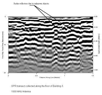 Figure 13: Ground Penetrating Radar transect from Building 3(BACH Area) |
Magnetic and soil resistivity studies were used to several meters of the upper crest of the mound. The magnetic study measured variations both in the total magnetic field and its expression at each reading point in the survey area. The instrument used this season was very sensitive and took 30 readings over each square meter, resulting in a photograph-like image of the magnetic properties of the area. Several large burned areas, what appear to be specific houses with distinctive rooms and room fills, and larger structures that may be Byzantine in age were all identified using magnetics.
Soil resistivity measures the variation in the resistance of materials in the ground to the passage of an electric current through them. We used an instrument that automatically measured resistance between each different pair of 15 electrodes, generating more than 180 readings along each 15 meter long transect and placed these transects in the same area where we had conducted magnetic studies. Although the dry conditions at the site caused the resistivity data to be somewhat noisy, we were delighted to see that there was adequate contrast between features in the resisitivy data. The way the data was collected will allow us to generate two and three dimensional maps of the survey area and we have already identified several intriguing structures in the same area where magnetic anomalies were identified.
Our studies this season revealed that several different types of geophysical methods can be effective at Çatalhöyük and can provide information at different depths and resolutions.