![]()
![]()
![]()
INTRODUCTION
Ian Hodder
This year the project celebrated its ten-year anniversary. Our work had begun in 1993, and the first major period of excavation by the Cambridge-Stanford team took place in 1995–99. The preparation of this work for publication has now been completed (four volumes to be published by the BIAA and McDonald Institute). In the meantime other teams had also started digging — especially a team from the University of California at Berkeley (BACH – led by Ruth Tringham and Mira Stevanovic) and a team from Poznan@ in Poland (TP – Team Poznan@ led by Lech Czerniak and Arkadiusz Marciniak). On the West Chalco¬lithic Mound excavations were conducted under the leadership of Jonathan Last and Catriona Gibson (English Heritage and Wessex Archaeology, UK).
Owing to unprecedented circumstances of war in Iraq, plans for the 2003 season were curtailed and as such a smaller and shorter season was undertaken. Progress was made, however, in our plans to open a 40 ? 40 m area to the north of the East Mound as well as to work under the newly-constructed shelter over the South Area which also incorporates the Summit Area first excavated by a team from Thessaloniki (Fig. 2).
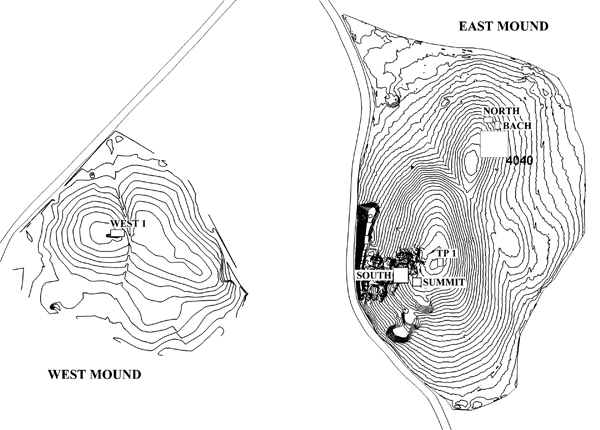
Figure 2: Areas of excavation in 2003
Excavation
In returning to excavation after a break for publication, the main Cambridge-Stanford team decided to shift gears in terms of its aims in 2003. In our earlier work we had concentrated on individual houses, and the same was true of BACH and TP. We had all focused on the details of specific houses, how they were lived in, re-used, and re-built and abandoned. It was time now to return to the bigger picture. Mellaart had excavated large areas in the 1960s, and we needed to return to this larger scale and work on how the site as a whole was organized. He and we had only found houses and areas of refuse. Were these buildings organized into groups? What was the social geography of the town? Were there bureaucratic or ceremonial centres that regulated the 3000 to 8000 people that lived there? How had the whole thing worked?
In order to examine these questions we decided to return to surface scraping as we had found in 1993–94 that the soil on the top of the mound was very thin. It only needed to be scraped with hoes for the walls of the latest buildings of the site to show up. In fact, by scraping large areas, the overall plan of part of the town could be recovered. So in 2003 we laid out an area 40 ? 40 m in size adjacent to an area in the northern part of the East Mound where we had previously scraped and discovered about 40 houses.
We quickly started seeing the layout of more buildings. But we also came across various difficulties. For a start, the 4040 Area extended down the sides of the northern eminence (Fig. 3); but as soon as we got off the crown of the mound, the amount of soil that had to be removed increased. Hoes had to be exchanged for heavier tools, and work slowed. Another difficulty was that we kept finding burials. These were right at the surface of the mound and had been partly destroyed by erosion and soil slip. Their archaeological context was thus insecure. Nevertheless some rich Byzantine and Neolithic graves were discovered. A number of the Byzantine graves contained ceramic and glass vessels, but it was the Neolithic burials that were most surprising. One burial pit contained a large number of skeletons, one of which wore a copper armband (see p. 8) while another had an alabaster one. Other Neolithic burials contained two stamp seals — the best preserved found so far by the current project. A third was very remarkable. It resembled a leopard, but with its head broken off. Part of its tail was also missing but it appeared to curve back and rest on top of the leopard (see p. 16).
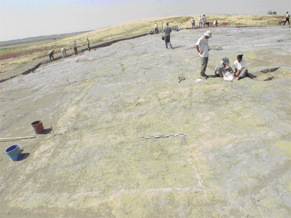
Figure 3. Uncovering Neolithic structures and late burials by surface-scraping Area 4040
Right at the top of the northern area we found the foundations of a large building (Fig. 4). There was no dating material for this but we presume it is Hellenistic, Roman or Byzantine, and of uncertain function. Hopefully future excavation will find some dating evidence in the foundation trench. The overall plan of the Neolithic buildings, especially when linked up to the earlier scraped area was fascinating. Definite ‘sectors’ could be identified. Houses were, as usual, tightly packed together, but there were gaps which defined clusters of houses (Fig. 5). In fact, these long linear gaps looked like ‘streets’ or ‘alleyways’. They all seemed to be directed towards the top of the mound. But instead of these alleys leading to public or ceremonial buildings, as one would expect, the top of the mound appeared to have been primarily used for refuse discard or as a midden. There were some buildings which seemed to have thicker walls, and we hope to excavate these in future years to see if they are distinctive in some way. But for the moment there is little evidence of public spaces or buildings — once again Neolithic Çatalhöyük seems to consist of just houses and midden. The pottery on the surface in the 4040 Area seemed to be mainly from about Level V, although material from other dates was also present.
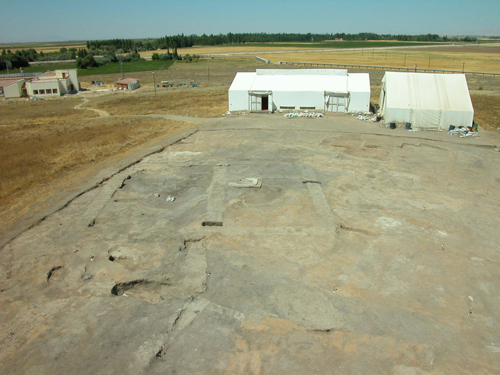
Figure 4. A large Late Period structure (Building 41) of uncertain function found at the top of the northern area
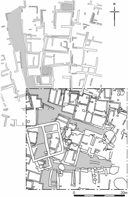
Figure 5. Building ‘sectors’ and possible streets, 4040 Area with 1993–94 scrape Area
Excavations also started in the South Area of the mound. This is where Mellaart had excavated in the 1960s and we had continued excavating there in the 1990s. Every year the snows and rains had caused erosion and damage, so we had covered up our trenches at the end of each season to protect them. Over this past year a huge shelter was constructed which could be completely closed in the winter. This was completed by Atölye Mimarlik just before the digging season. It covered an area 45 ? 27 m and created a wonderful even light and a protected environment for excavation, conservation, and public display. We have already started putting back reconstructions of the art found by Mellaart so that visitors can understand the site better (Fig. 6 & p. 17). We also have been excavating beneath the shelter, continuing the excavation of Building 10 that had been started by a team from Thessaloniki. In this building we found a bench that may once have had horns inserted into its sides (see Figs. 19 & 20).
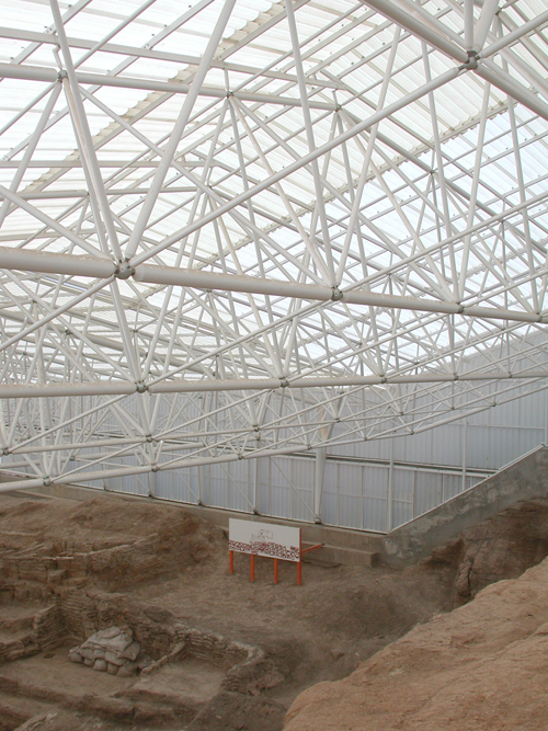
Figure 6. South Area showing the new protective roof completed in 2003 and in the
background a reconstruction painting of the art found by Mellaart
Other teams at the site also continued their work. The BACH team completed the excavation of Building 3 by removing the walls and exploring the foundations. Behind the plaster on one of the walls they found an entrance that had been bricked up. This suggests that entrance into buildings at Çatalhöyük was not always through the roof — sometimes there was a door at ground level, at least in some phases of occupation (see Fig. 12).
The TP excavations on the top of the main mound had been dealing for years with Byzantine burials and Roman features. Finally their patience was rewarded this year by a most remarkable find. After excavating through some very meagre late Neolithic buildings, they came across what we think may be a wonderfully-preserved collapsed roof! We had seen broken bits of roof in some earlier excavations — especially in Building 3, but this one seemed to be very well preserved. Lying at a sharp angle as a result of its fall, it consisted of thick layers of plaster interbedded with occupation deposits. Excavation of this next year will give an important and full picture of what activities took place on the roofs of the Çatalhöyük houses — at least in the warmer summer months.
Other activities
The project was honoured to host a visit by Nadir Avci, Director General of the Turkish Ministry of Culture and Tourism and his assistant Ílhan Kaymaz (Fig. 7), for a formal opening of the South Area shelter. The event was also attended by local politicians from Çumra and Konya and covered by local and national press. The project was hailed as a positive contribution to the Konya region and much support was voiced for the work of the project in its international character and the number of visitors the site attracts.
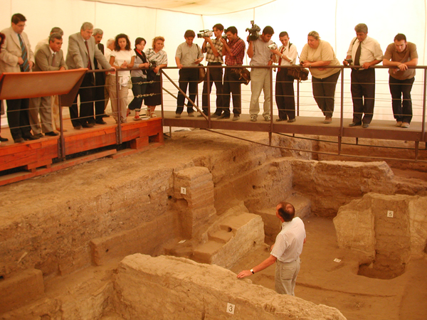
Figure 7. Nadir Avci, Director General of the Turkish Ministry of Culture and Tourism,
his assistant Iêlhan Kaymaz, and a number of local politicians from Çumra and
Konya on a tour of Building 5 conducted by Ian Hodder, on the occasion
of the formal opening of the South Area shelter
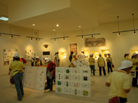
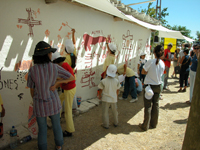
We also played host to about 70 school children from Istanbul, Konya, Çumra and Küçükköy. A day-long event with the children taking part in many on-site activities was organized by TEMPER (Fig. 8 & see p. 21). TEMPER (Training, Education, Management and Prehistory in the Mediterranean) is a Mediterranean-wide heritage project that involves six partner institutions. It is funded by the European Union and aims, over a two-and-half-year period, to raise awareness of the importance of the prehistoric heritage of the European Mediterranean, to encourage best practice in site management, and to produce educational programmes to encourage school children and adults to visit the sites and to develop an interest in prehistory at national curriculum level.
 |
 |
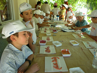 |
Figure 8. Temper education programme at Çatalhöyük (see also p. 21)
Towards the end of the season our newly-established Geomatics team organized the use of a portable Cyrax® 2500 3D Laser Scanner (see Figs. 1, 9 & p. 18). The scanning equipment was generously loaned by Cyra Technologies through their parent company Leica Geosystems, and the professional geomatic experience was provided by Plowman Craven & Associates, UK, to whom we are very grateful. This equipment enabled us to record Neolithic buildings at Çatalhöyük in a way that has been impossible in the past. With this 3D technology our plan for the future is for a virtual Çatalhöyük building to be accessed on the web with spatial information. Towards this end we are radically updating our data base into a truly relational environment and to provide a fully integrated, updated in real time, ‘live’ data base linked to spatial and image data that is accessible to all of our team from any part of the globe regardless of operating systems.
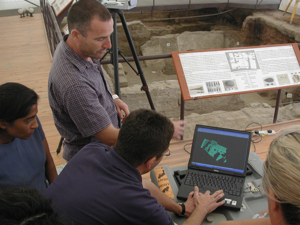
Figure 9. Scanning Building 5, North Area using a Portable Cyrax® 3500 3D Laser Scanner
Finally, as in previous years, the Thames Water Scholarship to assist young Turkish archaeologists was awarded. The three successful candidates are: Nurcan Yalman with assistance towards her PhD at Istanbul University in Ethno¬archaeology which involves attending some lectures at the Institute of Archaeology, University College London; Gunes¸ Duru also at Istanbul University and also to attend classes at the Institute of Archaeology, University College London; and Meral Atasag(un from Selcuk University to attend an English language class in London to help her in her Masters studies.
Last year’s candidates successfully completed their chosen courses and will submit short reports on their research which will be posted on the project web site.
![]()
![]()
![]()