![]()
![]()
![]()
EXCAVATION OF THE 4040 AREA
Joann Lyon & Jeremy Taylor
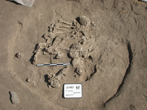
Figure 10. The remains of up to eleven individuals were recovered during the course of the
season from an area of approximately 4 x 4 m in the extreme northeast 5 x 5 m square
Between 1 July and 14 August 2003 an international team of archaeologists conducted an extensive surface excavation of an area measuring 40 ? 40 m to the north of the East Mound of Çatalhöyük. The aim of the season’s work was to expose, through surface scraping, the underlying Neolithic and later deposits similar to the work conducted in 1993–94 by Roger Matthews. The excavation was intended, therefore, to both compliment and add to the earlier ‘scrape area’, carried out just to the north of the 4040 Area. Only limited and localized excavation took place, the main aim being to map archaeological deposits and create an overall plan, with the intention of identifying possible areas for focused excavation during forthcoming seasons. For this reason interpretation and dating of any archaeological features must be seen as provisional.
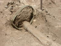
The investigation revealed a range of different archaeological features, which are thought to date mostly to the Neolithic with some Classical, Byzantine/Roman or Hellenistic periods represented. A number of burials were exposed, most of which were single interments of late periods at random locations across the area, but a few were also Neolithic.
Post-Neolithic structures were exposed at the crest of the area towards the west and southwest of the 4040 Area. The most complete building (Building 41) is 14 m square. The structure was identified by a series of wall foundations and associated wall collapse along the building’s eastern outer edge. Five spaces were identified within Building 41 with traces of a hard gypsum-type plaster floor in two small rooms. The overall plan of the Neo¬lithic buildings, especially when linked up to the earlier scraped area appear to define ‘sectors’. Houses were as usual tightly packed together but groups of buildings seem to have been defined by at least two linear open areas of varying widths, that have been referred to as possible ‘streets’ or alley ways, running east–west. They all appeared to be directed towards the top of the mound, but instead of these alleys leading to public or ceremonial buildings, the top of the mound seemed to have been primarily used for refuse discard or as a midden.
 |
 |
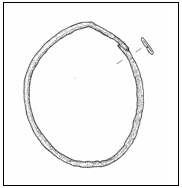 |
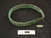
Figure 11. Copper armband found on one of the individuals excavated in the 4040 area.
Although copper has been found as small fragments throughout the Neolithic levels, nothing
of this size or type has been found to date which possibly pushes this complex of burials to
the Late Neolithic levels or even later, to the transitional Neolithic–Chalcolithic period.
![]()
![]()
![]()