![]()
![]()
![]()
GEOMATICS
Duncan Lees
The 2003 excavation season saw the first appearance in the field of the Geomatics Team responsible for all aspects of site survey as well as spatial data processing and graphical presentation. Working with the existing project coordinate system the grid was extended within all the excavation areas currently under investigation on both the East and West Mounds. The team also undertook a programme of digitizing excavation plans. The traditional hand-drawn plans produced by the archaeologists during the opening of the 4040 were processed and added to the digitally captured data to produce frequently up-dated computer graphics of the archaeological deposits as they were being revealed. This enabled valuable checking and reinterpretation to be undertaken whilst the archaeologists were still working on site, greatly increasing the quality of the records.
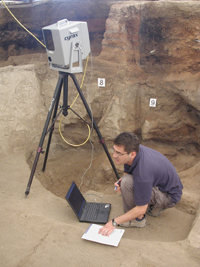
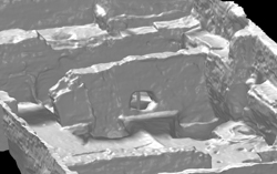
A portable Cyrax® 2500 3D Laser Scanner was also used for the first time at the site and possibly the first on any archaeological site in Turkey (Fig. 30). The scanning equipment was generously loaned by Cyra Technologies through their parent company Leica Geosystems and the professional geomatic experience was provided by Plowman Craven & Associates (PCA), UK. The system’s optimal combination of accuracy-at-range, highly adjustable scan density, high scanning speed, adjustable field-of-view, and ease-of-use greatly enhanced the recording of the Neolithic buildings with a greater resolution
(Fig. 31).
The geomaticians (Duncan Lees, Sophie Lamb, Dan Waterfall and Hüseyin Caner) supported all the excavation teams during the 2003 season, both on and off site, as well as commencing projects of their own.
 |
 |
Figure 30. Hüseyin Caner (PCA) using the portable Cyrax® 2500 3D Laser Scanner to scan Building 5.
 |
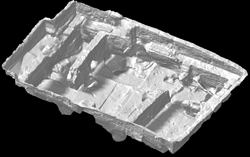 |
Figure 31. Computer graphic of Building 5 created with the portable Cyrax® 2500 3D Laser Scanner
![]()
![]()
![]()