![]()
![]()
![]()
THE 4040 AREA EXCAVATIONS
Doru Bodgan, Lisa Yeomans, Shahina Farid, Ulrike Krotscheck & Candemir Zoruğlu
Late activity in this year’s 10x40 strip consisted of part of the foundation trench of a probable Roman/Hellenistic building (Building 41, Spaces 212 and 216). This was located to the centre west of this year’s excavation in the 4040 Area. Surface scraping in 2003 when the destruction phase of the buildings, as well as some occupation layers were excavated first exposed this square structure. The foundation cut and fill, which cut through the Neolithic layers was not however excavated until this season. The foundations were made of clay, solidly packed in deep, wide trenches, suggesting the possibility of a multiple storey construction. The clay fill was clearly collected from the mound and it contained a quantity of Neolithic material.
A number of late burials were excavated stretching across the length of the10x40 strip. These appear to date from the Late Roman/Byzantine period displaying a typical position and orientation for this period. Most graves were simple rectangular cuts with single extended burials. The bodies were in an extended position with the heads to the west and the feet to the east. There was one exception to this pattern where the feet were to the west and the head to the east. Most of these skeletons were extended on their back but five individuals lay on their right side. These five individuals were clustered together in the southern sector. Four graves were clay lined, and three had evidence of coffins by the presence of iron nails and traces of decayed wood. One burial may have been disinterred and a further collection of human bone may have been a ‘clearance’ activity. Only two burials had associated grave goods. The different types of burial practices probably represent different phases and or cultural practices. The corpus of classical data from the site will be collated and reported on once it can be put into context with the off-site investigations currently being undertaken by a team from Selcuk University.
As was established last season the different zones of Neolithic buildings in the 4040 Area, which had first been interpreted as contemporary neighbourhoods delineated by streets (2003 Archive Report), were, upon excavation, identified as different occupation phases (2004 Archive Report). Although overall there was a paucity of artefacts by which to date the buildings excavated, the occupation phases (termed as Levels) presented last year fitted with this seasons work too. As such the latest Neolithic activity was identified in the central cluster of buildings, which is equated to Levels IV –II, bounded by midden areas Space 271 to the north and Space 275 to the south. No work was conducted on the Neolithic sequence in the southern most sector of this year’s 10x40 strip, but judging from last seasons results the activity here is likely to represent Levels VI – V, whilst the latest is represented in the northern most sector of buildings, dated to Level VII – VI.
Space 267, a midden area to the west of the central cluster of Neolithic buildings was defined by wall F.2029, (10379) and a layer of eroded mudbrick (10378) and extended to the west beyond this year’s excavations. A lack of associated floors within Space 267 suggests that these wall remains are the footings to a now eroded building. The wall footings and erosion of Space 267 overlay two infants positioned at the interface of a pit fill (10380). Space 267 replaced an earlier and larger midden area Space 268, which also extended to the west of the limit of excavation. In a number of places the midden had been truncated by Neolithic pits which where themselves backfilled with layered midden material or more homogeneous dumps of waste. The midden deposits were typically layered and rich in finds and environmental data. Work was conducted in this area as far as to release the buildings to the north, east and west. Future excavation will take place when more of the area can be defined to the west.
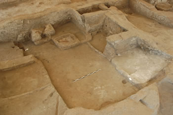
Figure 11. Building 58 showing the oven against the south wall and a hearth close by. Two cell-like spaces can be seen against the west wall (right of the photograph) and there are platforms and a bench along the east wall. |
Located on the eastern side was a well-defined rectangular building (Building 54) with double outer walls, divided into three spaces by two interior walls and with internal measurements of 4m E-W and 8.5m N-S. Abutting / abutted by, adjoining Buildings 58 and 57, its sequence in relation to these buildings will not be established until complete excavation but at this stage looks to be the latest. Being very close to the surface most of the interior features had suffered erosion leaving only some sequence of floors, a bin and a clay lined cut in the northern room Space 264, and a number of burials. In the northern room six babies were interred under the floors, while in the eastern one, three adults were found. In the largest space of the building another neonate was buried, as well as a juvenile.
Probably earlier than, and located to the north of Building 54 lies Building 58 (Figure 11). In its latest phase it comprised three spaces, a larger Space 227 with a narrow room, Space 258 along its western length. To the south of Space 227 was a small Space 274, which was probably originally an access between Spaces 258 and 227 but in the buildings latest phase it was blocked and formed a small enclosed room Space 274. The internal space measures c.6.5m x 4.0m.
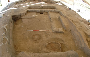
Figure 12. Building 55 looking north, showing a circular oven against the south wall with a hearth close by. Platforms can be seen against the north and east walls. |
The internal layout in Space 227 formed three cell like areas along the western wall, the northern and central housing platforms with retaining kerbs facing into the room. The southern most cell forming the later Space 274. Along the eastern wall was a double platform with a southern bench and against the south wall was a rectangular oven with associated large square hearth constructed on top of a platform in the southwest corner. This oven was deliberately infilled prior to closure of the building and a final conclusion event appears to have been the placement of a cattle skull and dog into the mouth of the oven.
The occupation sequence in Space 258 was heavily truncated with minimal survival of features but four neonate burials were found cut through the floors in the northwest corner and three in southwest corner.
Building 55 (Figure 12) would have been a large building comprising of a main square room, Space 256 with a northern storage room, Space 247. The larger room contained an oval oven abutting the southern wall with surrounding dirty floors contained by a kerb extending from the eastern side of the oven.
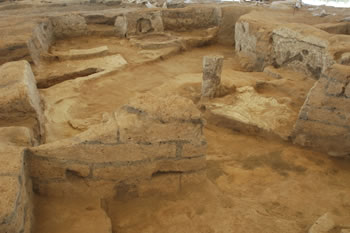
Figure 13. View into Building 57 looking south towards the oven ‘decorated’ with an incised meander pattern and the free-standing mud-pillar. Platforms are arranged along the east and west walls. |
The oven would have been a domed structure with an opening on its western side. A large platform extended from the NW corner of the building. In the NE corner another platform was connected to a third platform built against eastern wall. The surface of the eastern platforms was slumping considerably into two hollows suggesting that the platforms had been opened many times for the burial of individuals below. The eastern side of Space 256 also contained two benches; one was a mudbrick construction parallel with the eastern wall, and the other at the southern end of the eastern platforms. A post retrieval pit was located approximately mid-point along the northern wall.
There was no internal entrance between the main room and the storage room to the north. Approximately one third of the internal area of the room was taken up with three storage bins built against the southern wall but concentrated on the eastern side of the space. Two opposing postholes at the western end of the bins is evidence for a possible partition that defined ‘clean’-plastered floor to the west where another type of food or material good was stored.
Heavily truncated by the foundation trench of the Classical structure, Building 57 comprised two rooms: a small Space 270 to the north and larger Space 269 to the south (Figure 13). The smaller was possibly used for storage, but only contained a double basin feature and a niche in the eastern wall. No crawl-hole was found between Spaces 269 and 270 although any evidence of such a feature may have been truncated away by the late foundation trench. Although the floor sequence was not excavated, the room does contain a number of infantile burials that were seen in the section of the foundation trench.
The larger room was furnished with the usual suite of features, platforms along the eastern wall with a bench at their southern end. More platforms were located in the northwest quadrant of the room too, but these appear to be set within alcoves created by two short wall buttresses, similar to those in Building 57 but not as cell-like. A unique feature was found in the northwest quadrant of the room, which was a freestanding, plastered, mud-core pillar. It stood c.0.5m high and its basal plaster was continuous with a kerb linking the pillar and platform, creating a partition. A small basin or truncated bin stood in the southwest corner of the building, but built against the centre of the southern wall was perhaps the most attractive feature, an upright, rectangular oven with a semi-circular oven mouth opening on to a relatively large square kerbed hearth. The whole was heavily plastered and above the opening was a shallow mantle or ledge with deeply incised parallel waves creating a decorative feature, very similar to the wavy designs on clay stamp seals.
Open areas bound the central cluster of buildings to the north and south. To the south Space 275 is a continuation of Space 226 excavated in 2004, and to the north space 271, a continuation of Spaces 232/240 also excavated in 2004. These ‘open’ areas were initially presented as streets between discrete blocks of buildings when first exposed through surface scraping in the 4040 area in 2003. However, upon excavation it was established that these open areas delineated occupation periods as opposed to contemporary building zones or neighbourhoods. Minimal excavation was conducted in these areas, only as far as to articulate the buildings targeted for excavation and to gain enough of a sequence and characterisation of these areas. Dating of these external areas was therefore no further elaborated from 2004.
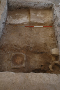
Figure 14. This small compact Building 51 was furnished with platforms against the north wall and oven area to the south. It was built within the ‘footprint’ of burnt out Building 52. |
Up to four structures are represented in the northern sector of buildings of which Building 51 represents the latest followed by Building 52 and then structures to the west called Space 90. The construction sequence is based on the stratigraphic relationship of the buildings exposed but no dating was possible because of the paucity of finds. A tentative date of Levels VI – VII is based on the meager dates retrieved from last years excavations.
Building 51 comprised a single small room Space 98 (Figure 14). Two stepped platforms lay against the north wall with a niche cut into the east wall leading on to the NE platform and a post pit at the southern end of it. Phytolith traces of a woven mat were also clearly preserved on the surface of the NE platform (Figure 15). The southern area of the building functioned as the food production area with a hearth surrounded by a raised boundary. There was no oven but the hearth was set relatively close to the southern wall in the position where ovens are frequently positioned and is the likely location of the entrance ladder. Positioned in the southeastern corner were a bench, a pedestal, and a double basin.
The most important piece of information about this structure is that it appears to have been built as a replacement for Building 52, which was destroyed by fire. Building 51 was constructed within the walls of a cleared out area of the burnt building in the northeast corner.
Figure 15. Phytolith traces of a woven mat were also clearly preserved on the surface of the NE platform. |
Building 52 is a burnt building and the question of whether the fire was deliberate or accidental is still under debate amongst the team members. The complete plan of the building is obscured by the location of Building 51, which is constructed within the walls of Building 52, but the plan exposed appears to consist of at least six rooms (Figure 16). The two western rooms, Spaces 91 and 92 were probably a later addition. To the south the stratigraphic relationship of two small rooms, Spaces 254 and 255 has yet to be investigated. Space 93 to the north was a storage room with four bins arranged against the north and east walls (Figure 17). Large quantities of carbonized cereals, almonds and cruciferae seeds were found in the bins. There were also a number of groundstone artefacts and faunal remains found across the floor and within the burnt debris filling the space, which indicates that the space may have been used for house-hold production of food and implements.
The revealed part of the central room (the western half), Space 94, was occupied by two raised platforms with a centrally positioned E-W bench. The bench had three right sided cattle horn-cores fixed in a row on the northern side of it, adjacent to a cattle skull with horns installation set within a niche in the western wall, and facing into the room.
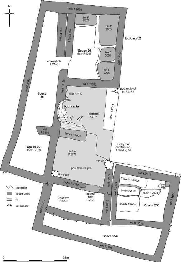
Figure 16. Plan of Building 52 showing six rooms. |
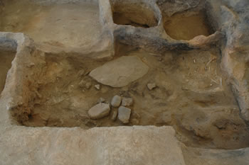
Figure 17. Space 93 to the north was a storage room with four bins arranged against the north and east walls. Large quantities of carbonized cereals, almonds and cruciferae seeds were found in the bins as well as groundstone artefacts and faunal remains. |
The earliest structural activity in this northern cluster of buildings lies to the west of Building 52 and first exposed through surface scrape in 1993-4. Space 90 appeared as a well-defined room with walls on three sides, the western side lying beyond this years 10x40m strip, and with a potential internal partition wall. However it soon became apparent that the walls were an agglomeration of several phases of activity and most importantly, earlier than Building 52, so as much was recorded as was necessary before concentrating on excavation to the east in phase.
![]()
![]()
![]()