
ÇATALHÖYÜK 1997 ARCHIVE REPORT
    |
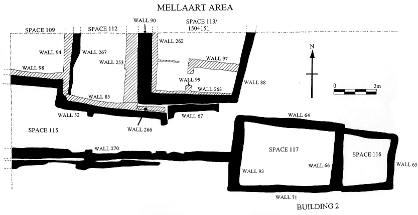
MELLAART AREA
Shahina Farid
Introduction
The 1997 season of excavation in the Mellaart area was conducted over a two month period from the 4th August to the 25th September with backfilling taking place of the 27th September.
The area excavated in 1996 concentrated on the east west aligned row of structures that lay to the north of Mellaart's excavation areas known as Shrines 1, 8 and 10. From the east these northern structures were re-defined as Spaces 105, 106, 107 and 108, previously known as Courtyard 15 : Level VII and VIII, Room 16 : Level VII, Room 2 : Level VII and Room 12 : Level VII. This phase of structural activity represented by spaces 106, 107 and 108 had been constructed over an 'open' area, space 115, interpreted as a 'midden' space and defined by fine accumulative deposits of domestic debris as opposed to building debris and collapse. As space 115 this 'open' area stretched across the whole area from east to west as defined above. However its northern limit has as yet not been fully defined and to the west it continues beyond the limit of excavation. ( the area of excavation is a 20 x 20 metre area, see archive report 1995). When the structures represented by spaces 106, 107 and 108 were constructed and in use space 105 continued to be used as an 'open' area (Mellaart courtyard 15).
By the end of the 1996 season the walls of a new structure, building 2, had been defined which was located to the east, below space 105 and sealed by space 115. This comprised a two spaced building, spaces 116 and 117, which were backfilled by dumps of mixed deposits. The 'midden' deposits of space 115 to the west of building 2 were not completely excavated.
This seasons work continued on from last year in Building 2 but otherwise concentrated on the area to the north of the spaces that were investigated in 1996. From the west these are represented by spaces 109, 112 and 113, previously known as Room 19: Level VII, Shrine 9 : Level VII and Room 7 : Level VII. These are only partial representations of the structures as the edge of the excavation bisects the buildings to the west and north. To the east of space 113 lies Mellaart's Shrine 14 which he had excavated down to Level VIII.
Towards the end of the season some work was carried out in space 115.
The initial work in these spaces consisted of dealing with the remains of buildings that Mellaart had excavated, and the identification and interpretation of those deposits in order to relate them to his preliminary reports and plans (see Fig. 2).
Space 109
Space 109 (Fig. 3) measured an area of about 3.0m N - S x 2.8m E -W and was defined by walls to the south and east and by the limit of excavation to the north and west. It very roughly represented a quarter of the building as a whole. Excavation in this space stopped at an arbitrary horizon at the end of this seasons work within infill deposits to an earlier building. As with the later, the earlier building was defined by walls to the east and south which were not fully defined. The infill was excavated as arbitrary layers represented by units 2085, 2080, 2075, 2068, 2061/2816 and 2010/2813, consisting of a homogenous and well mixed matrix of clayey silt with relatively little cultural material. The material appears to have been imported into the area as opposed to in situ debris from the demolition of the earlier building or its roof.
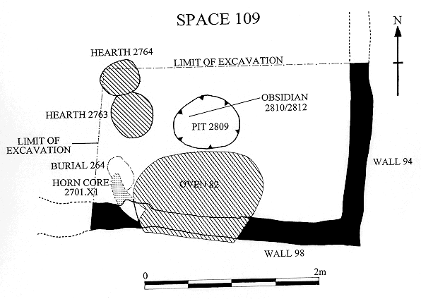
The infill lay flush with the top of its containing walls and the tops of the walls were neatly levelled in order to service as a foundation for the construction of the later walls. The later walls, 94 to the east and 98 to the south were constructed post infill directly on top of the earlier walls but very slightly off-set towards the east and south. (It ought to have been possible for the later walls to have been constructed prior to the complete process of infilling or even mid way through the infilling at a convenient horizon, however this was not the case as far as the stratigraphical sequence showed). As well as having been constructed over earlier walls, wall 98 abutted wall 52 to the south, the north wall to spaces 108 and 107 and wall 94 abutted wall 267 to the east, the west wall to space 112.
Incorporated into the south wall at the time of construction was a rectangular void to house a fire installation 82.
Post construction of the walls deposits represented by units 1894, 2312, 2000 and 2805 were laid. These have been interpreted as, or a combination of, levelling/make-up/consolidation and foundation layers. Unit 2312 represents the area of this deposit in the alcove of the fire installation which in section had appeared slightly different in composition to the rest of the equivalent layer, however on excavation this difference was fugitive and was much the same as 2000 and 2805 whilst 1894 was a discrete layer filling a hollow against the length of the east wall. This horizon of levelling was overlain by the first of the series of floor and wall plaster applications.
The floors were represented by units 1892, 2756, 2768 and 2801 and it was at this horizon that Mellaart had stopped his excavation. As a consequence, the surface was heavily disturbed by weathering and root activity and there was very little survival of wall plaster. From Mellaart's preliminary report plans it is clear that he exposed this horizon which consisted of a fire installation against the southern wall and platforms to the west, however it was not clear how much of this phase he had excavated.
A truncated platform was evident along the western edge of space 109, beyond the area of excavation, and the fire installation was located against the south wall, both of which fitted in with the previous expeditions plans. The fire installation feature survived as a semi-circular form with a raised rim of 0.1m width and an average height of 70mm, it measured about 1.5m E-W x 1.0m to the wall face and a further 0.4m in the alcove of the wall. Again it is not clear how much of this feature was excavated by the previous expedition, whether it was originally a feature with a superstructure or as exposed this year as a shallow feature with a rim forming an enclosure. It also appears that Mellaart did not trace the fire installation within the alcove.
Survival of the floors was very patchy and not always obvious and because of the poor condition these were excavated as one layer. Where survival was good, generally in the south west corner at the junction of the south wall and the west platform, there were 9-10 visible floor layers within a 60mm depth of section, each separated by a lens of mud plaster and a basal preparatory layer 30mm thick.
Associated with the floors towards the centre of the space were a series of features consisting of two shallow fire installations in the form of fired and scorched circular scoops and a small pit. Unfortunately because of the state of the floors the stratigraphical relationship of these features could not be established.
The pit cut represented by unit 2809, measured 0.62m in diameter and 0.25m deep and was fairly irregular. It contained one fill 2808 of mixed composition within which was found a discrete cache of 7 obsidian bifaces. The grouping of this cache suggested it may have originally been held in a container for which there was no other evidence. The cache was sealed by the same infill deposit indicating a single event and sealing the fill were two unworked obsidian pieces represented by unit 2810. The relationship of the floors and the pit fill event was lost due to the weathering of this horizon and therefore an interpretation can be twofold; if the pit fill was sealed by the floors this event may be interpreted as some form of 'ritual' foundation deposit but if the pit cut the floors it may be interpreted as a storage feature.
The two 'fire scoops' were represented by units 2763 which had a 'lining' 2762 and fill 2759 and beside it was scoop 2764 filled by 2760. Both appeared to be one event fires with associated rubified deposits and scorched backfill. Again because of the weathering of the area the inter- relationship was not apparent. The function of these features and their significance in relation to the larger and more substantial fire installation 82 is unclear, however interpretation may become more apparent as and when more and similar features are excavated in other areas.
Much of the fire installation 82 had been destroyed by animal burrows and general poor condition through weathering since the 1960's expedition. However excavation illustrated a history of use, rakeout and remodelling. The feature was integral to the construction and use of the building as illustrated by the incorporation of the void in the south wall 98 at the time of construction. The basal deposit represented by units 2751, 2717 and 2309 was interpreted as a bedding/foundation deposit for the fire installation. It appeared to have been laid before the accumulative floors but because of the poor condition overall this relationship was not so clear. This deposit coincided with the overall plaster rendering of the cavity represented by unit 2090. The next sequence of units 2749, 2743, 2742 and 2727 represented patches of rubified floors and packing associated with the use of the fire installation of which the latest deposit 2727 was traced beyond the alcove where it appeared to interdigitate with the surrounding floor deposits. These deposits sealed burial 264 which was located to the west, between fire installation 82 and the platform in the west section. The burial cut 2773 contained a single infant burial 2772 within backfill 2771 and was sealed by floors 2727.
A remodelling phase of the fire installation took place post floors 2727. Units 2700 and 2701 represented packing of compact ashy deposits within the cavity of the fire installation against which a new 'wall' 2397 was modelled. Within the packing deposit was the remains of a cattle horncore 2701.X1. The blunt end of the horncore was set within 2701, however the protrusion of it beyond the face of the wall was only apparent as an outline in the underlying deposit as most of the bone had been removed by a burrowing animal. This incomplete picture has thrown doubt on the feature as a whole particularly as it breaks one of Mellaart's established patterns: this is the first example of some form of 'decoration' on the south wall; it is the first example of such a decorative feature beside a fire installation and the first of this type to be found at floor level. The evidence that the horncore protruded the wall face lay in the deposit represented by unit 2736. This was a raised wedge of accumulated deposits on the extrapolated alignment and curvature of the horncore. This 'outline' could only have resulted by the excavation and cleaning or defining of an object of this shape and size. It had survived since the 1960's excavation which implies that the horncore was visible and excavated at that time.
Associated with the blunt end of the horncore and prior to the deposition of the packing deposits 2710 and 2700 was an area of plaster 2748, it overlay the plaster rendering 2090 but only in the area of the blunt end of the horncore. This horncore feature also lay in the same location as the earlier infant burial 264.
Coinciding with the remodelling of the fire installation and the horncore was 2733 (same as 2043, 2045 and 2049), which represented the rim around the fire installation first exposed by Mellaart's expedition. Upon excavation of this deposit it was found to consist of several accumulated lenses as opposed to material forming a structural feature, once again the relation of this to the original feature is unknown, however the rim did retain ashy deposits associated with the use of a fire installation. These internal deposits were very fine and accumulative in nature represented by 2397, 2381, 2379 and 2378. Between 2397 and 2381 a truncation horizon 2386 was recorded which was interpreted as a 'rakeout' event.
Sealing the fire installation and floors were erosion deposits accumulated since the 1960's project which were excavated as 1869.
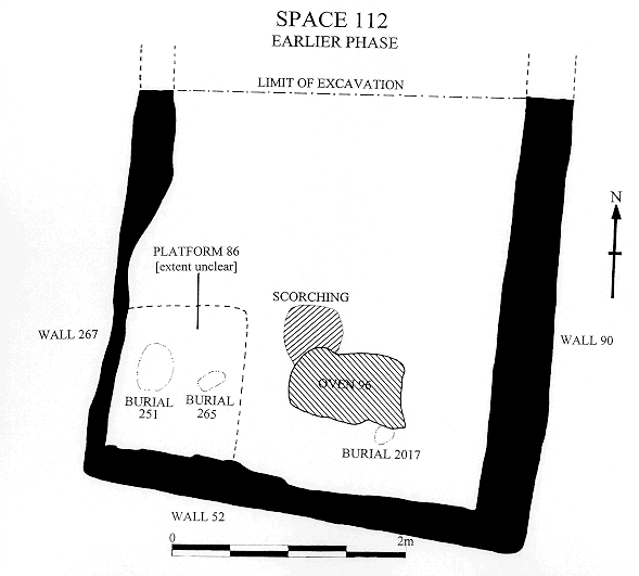
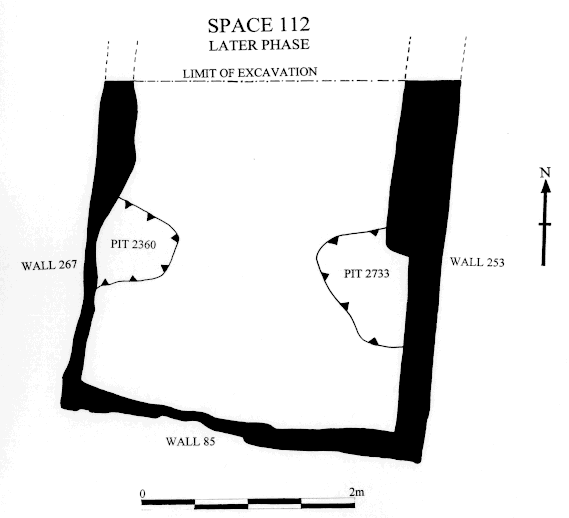
Space 112
Space 112 (Fig 4 and fig 5) was located immediately east of space 109 and represented only about half of the building. It measured about 2.4m E-W x 3.6m N-S and was bounded by walls to the east, west and south with the edge of excavation marking its northern extent.
Excavation progress in this space was hindered by an unexpected number of burials and consequently work stopped at an arbitrary horizon at the end of the season within building infill deposits. The infill was excavated in arbitrary layers as units 2776, 2305, 2735 and 2716 which represented a homogenous fill with relatively little cultural material.
This infill was contained within walls 267 to the west which at some stage functioned as a party wall between spaces 109 and 112. The south wall was wall 52 which was a continuation of the early south wall to space 109 and also functioned as the north wall to spaces 107 and 108 and to the east the space was bounded by wall 90 which although not completely excavated appears to have been a party wall to spaces 112 and 113.
A number of features were located at this horizon of infill after the excavation of remnants of floor deposits, units 2096. However because of the difficulty of tracing cuts within these deposits it was unclear as to whether these features were sealed by, or cut through the floors.
In the southwest corner were two single infant burials 265 and 251. Towards the centre south was a large area of scorching which was revealed to be remnants of a fire installation 96. This consisted of several firing events represented by burnt layers and ash, fills within shallow scoops and a layer of clay ball fragments. A series of dump or infill deposits represented by units 2306, 2083 and 2013 sealed this fire installation phase. Unit 2013 contained a neonate 2017 with no apparent burial cut. Unit 2027 represented the remnants of floor deposits over the fire installation and was probably the equivalent to 2096.
Part of a platform 86 was defined in the south west corner abutting wall 52 to the south and wall 267 to the west. This must have been part of a series of platforms Mellaart's team found as seen in the preliminary report plans, however this small section of platform was missed by the previous expedition because the southern wall was a late construction built over the platform, this only became apparent on excavation. A double burial of adolescents was associated with this platform burial but any associated burials from the previous excavation are unknown.
Two semi-circular pit cuts were also excavated. Cut 2360 was located against the west wall and cut 2738 against the east wall. Both contained a high proportion of re-deposited wall plaster and plaster moulding fragments within their respective backfills. The significance of these two features lies in the stratigraphical sequence in that they coincide with the construction of the later walls, 253 to the east and 85 to the south. Their interpretation has been defined as receptacles for dismantled wall plaster and/or plaster mouldings from the earlier defunct walls. The burial of these fragments must be of some significance and may link in with the 'ritual' dismantling of, or destruction of, the west wall. A pattern that Mellaart first noted in the 1960's excavations and one which is emerging from the present excavations.
Wall 85 was constructed abutting the south wall 52, over platform 86 and keyed into wall 267 in the SW corner. It was bonded to wall 253 which was constructed abutting wall 90 to the east. Neither of these walls have been completely excavated but it appears the east wall 253 was constructed as a revetting wall to wall 90 which had developed a severe slump towards the west. The south wall 85, must represent a construction technique to consolidate the new east wall. There was no equivalent west wall construction where there was no apparent slumping.
Two further burials were excavated, burial 89 was located towards the centre of the space and consisted of two adult burials, skeletons 2056 and 2058, and burial 83 was located towards the south west corner, parallel to burial 84, and contained a single adolescent interment, 1884. It is not known whether these burials were associtaed with the first or the second phase of construction.
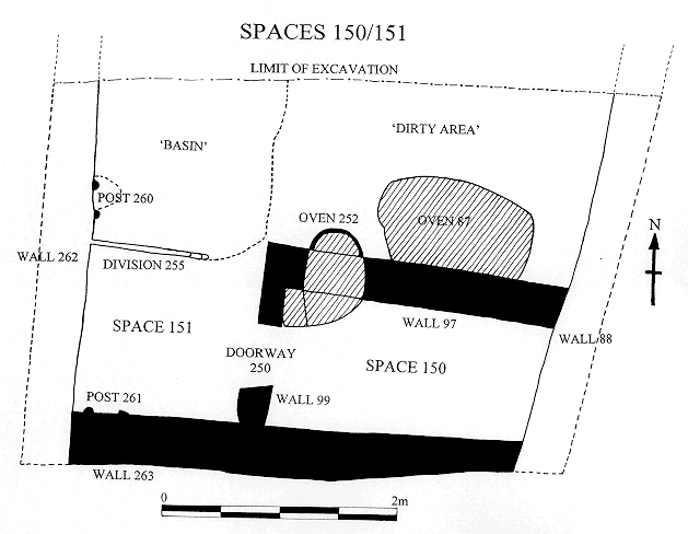
Spaces 150, 151 and 113.
Two building horizons were defined this season in the space east of space 112. The earliest consisted of two rooms; a small room in the southeast corner, space 150 and a larger 'outer' room, space 151. This 'building' was succeeded by space 113 which was mostly excavated by Mellaart's team (Fig 6 and fig 7).
The area covered by these spaces was about 2.3m E - W x 3.1m N -S and bounded by walls to the east, west and south with the edge of excavation defining its northern limit.
Space 151 was defined by wall 262 to the west, wall 263 to the south and wall 88 to the east and wall 97 formed the north wall to space 150 which abutted wall 88 to the east and incorporated a short southbound return to the west, the terminus of which formed one side of a doorway/opening 250. The other side of the doorway was formed by a stub of wall 99 which abutted wall 263 to the south. The east and south walls were shared with those of space 151, walls 88 and 263.
For logistical reasons work stopped at the floor horizons of these spaces this season. Generally the floors had been severely truncated at the end of the life of the building resulting in irregular and isolated patches and pedestals of floor deposits. The composition of the floor deposits varied across the spaces; in the location of the fire installations in the north east corner these deposits were characteristically ashy and charcoal rich and appeared to have accumulated through use and rakeout of the fire installations whereas elsewhere the floors were characteristically 'clean' plastered floors. This clear division between 'use' areas within the buildings is a pattern that was recorded in some of the sections studied in the 1993-1994 seasons and appears to be a pattern of some significance. As this phase of building has not been fully excavated it is too early to surmise what it represents.
Features that were defined were not fully excavated.
In the north west corner of space 151 was the physical feature that created the division between the 'dirty' area around the fire installations and the 'clean' area elsewhere. This was a shallow feature formed by a thin wall 255 to its south and a ridge to the east. It appears to have been a shallow basin however it has not been fully excavated and its surface has been disturbed by later activity.
In the north west corner of space 150 was a fire installation 252 which was built through wall 97 with an opening and the remains of a truncated structure in space 151. At this stage it appears that fire installation 252 went out of use, it was blocked from space 151 and a larger fire installation 87 was constructed to the east of it. This was a larger feature with a domed superstructure and a possible opening on the western side.
A series of events took place at the end of the use of these two spaces. Doorway 250 was blocked by infill 2314 and space 150 was backfilled. It has been argued that space 150 may have been backfilled at the time when fire installation 252 went out of use and only space 151 continued to function. At the moment because of the incomplete state of excavation there is no evidence for or against this sequence.
The basin type feature in the north west corner of space 151 was truncated. This truncation has been associated with a post scar/impression 260, on the east face of wall 262 at this location and consequently interpreted as a post retrieval event. A similar post scar 261 was found in the south west corner on the south wall but no associated post retrieval cut was found.
The tops of the walls were truncated presumably in conjunction with the dismantling of the roof although there was no sign of roof material in the subsequent backfill of these spaces. The southern wall was truncated in a stepped fashion from east to west, presumably to key the later wall, whilst the walls to the west and those to space 150 were truncated to form a level horizon. The east wall 88 was not disturbed and continued through to be re-used in the next building horizon. The fact that wall 88 was not remodelled may have been due to the restrictions posed by the neighbouring house to the east, space 114 (Shrine 14).
The spaces were infilled with relatively sterile material and a new phase, represented by space 113 was established.
Space 113 comprised a single area bounded by wall 88 to the east, wall 75 to the south and wall 90 to the west which was a party wall with the early phase of space 112. The backfilled space
150 formed a very shallow raised platform in the south east corner but whether this formed a feature of any significance is not clear. The south wall incorporated a doorway 95 which has not yet been linked to a contemporary space to the south. This doorway was at some stage during the life of space 113, blocked, an event which may link in with the construction of space 106 to the south. This blocking was then reopened represented as cut 2095 which formed a smaller cavity than the original opening 2300. The second opening very likely represented a niche as opposed to a doorway as it opened on to a wall face to the back which was plastered (it can't have been coincidence that the plaster coincided with the area of the opening only).
Most of the floors associated with space 113 had been excavated by Mellaart's expedition and what was left was accidental. Consequently the floors were mostly represented as slivers against the wall faces and in cavities produced by slumping. One such event was located over the blocking of doorway 250, where later floors associated with space 113 had slumped. Located just in front of opening 95 and cutting these floors was feature 92. This consisted of a series of small and shallow cuts, two of which contained obsidian caches 2038 and 2039. Their association to the opening 95 was lost due to the work of the previous expedition and therefore it is unknown as to whether these features represent a post blocking or pre-blocking event. The feature lay in a classic liminal location, however apart from it representing a 'ritual' significance it may represent a functional purpose, that of a store of material.
Post floors in the south east corner a pit 91, was cut. The function of this feature is unclear and at which stage of the use of the building this feature was cut is not known, however the fact that the cut respected the limitations imposed by the walls of space 150 may indicate an event associated with space 150, in that perhaps this too represented some form of retrieval event.
The deposits and features excavated in space 113 in the 1996 season were all located in this south east corner but it is not yet established whether they were part of the upper fill of pit 91 or whether they post-dated it.
Towards the end of the season the walls to the south of spaces 113, 112 and 109 were investigated and fully or partially excavated. There are a number of anomalies that remain to be addressed but so far the sequence appears to be that wall 267 was one of the earliest walls represented in this area and part of a building that is not apparent at this stage of work. Wall 52 was constructed abutting wall 267, and wall 267 was then reused in this later construction phase as the dividing wall between spaces 112 and the pre 109 space. Wall 52 thereby created spaces 107 and 108 to the south, space 112 to the north and possibly an earlier version to space 109. Wall 52 must have been contemporary with wall 90, the dividing wall to spaces 112 and 113 and therefore it appears that walls 262 and 263 to spaces 150 and 151 are earlier than walls 52 and 90 and that wall 75 is also contemporary with walls 90 and 52. Later revetting walls 253 and 85 were constructed within space 112 and space 109 was created by the construction of walls 98 and 94.
A series of isolated walls are represented between spaces 113 and 106 represented by 61, 67, 266 and an earlier un numbered wall. It would appear that 266 represents an infill event possibly at the time when walls 75 and 52 are constructed or that wall 75 post-dates wall 52 and 90 and that spaces 151 and 150 were still in use when spaces 107, 108, 112 and the earlier version of 109 were constructed. Space 113 was then constructed over the levelled walls 262 and 263, wall 75 constructed over 263 and wall 90 became a party wall between spaces 112 and 113. Wall 266 was inserted as infilling in what appears to be a gap between spaces 107 and 113. Walls 67 and 61 may be associated with later buildings not represented due to the earlier expeditions work. Some of these relationships will be resolved with further work, specifically at the wall junction of spaces 113, 106, 105 and 114 (Shrine 14)
The 'open midden' area space 115 pre-dates spaces 109, 112 and 113. It was only partially excavated this season and continued to yield the same type of deposits as were excavated in the 1996 season. Wall 52 was constructed over these 'midden' deposits and although there is no evidence as yet it is likely that the 'midden' deposits do not extend much further north and that they will abut space 151/150 and buildings below spaces 109 and 112.
Little work was conducted in space 116, the eastern room to building 2 because work concentrated mostly in space 117. The walls of the building had been defined by the end of the '96 season and infilling dump deposits had been excavated, these deposits continued to be excavated in space 116 this season. The 'bin' feature 52, defined in the north west corner last season, on further investigation was found to be collapsed bricks and plaster. Its excavation revealed large fragments of collapsed plaster mouldings. These fragments have not been fully defined but applications of plaster over cores of clean and fairly pure clays have been identified and suggests they represent collapsed or re-deposited moulded feature fragments.
The infilling of space 116 was pretty much the same in characteristics to the infilling of space 117, consisting of dumps of material composed primarily of domestic and building debris. These dumps were indicative of accumulation over a period of time as opposed to quick infilling as seen in spaces 109, 112 and 113. A slow process of infilling during a period of abandonment was also indicated by the presence of owl pellet deposits. These are characteristic of abandoned buildings and are usually deposited from a height such as from roof beams or the tops of walls.
The floors in space 116 were not defined this season, however the top of the 'crawlhole' between spaces 116 and 117 was defined.
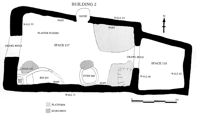
Space 117
by Roddy Regan 28/9/97
The season ended having reached the upper floor and internal features of space 117 (Fig 9). The building itself proved, as with building 1, that internally the building was 'busy', with differing areas given over to hearths, ovens, clean and dirty areas as well as platforms, the spatial relationships between these internal features differing over time and space. The stratigraphic sequence within the room may not be that complicated but it is only early days yet.
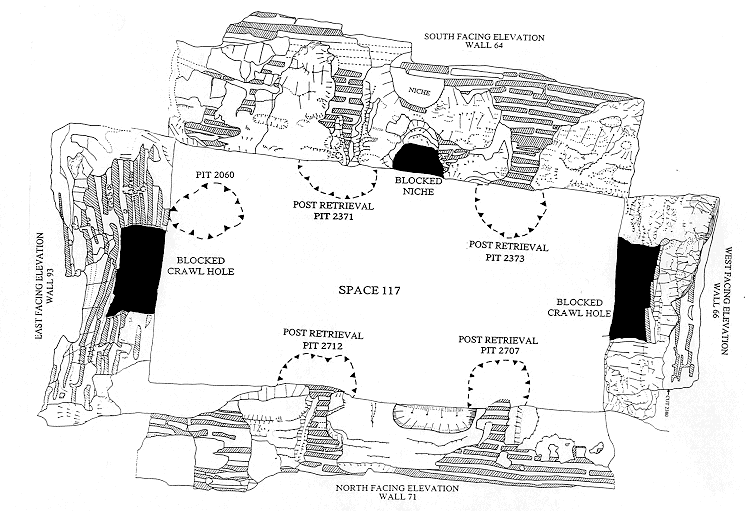
The season began by the continued removal of room fill by arbitrary spit, a process began last year. These consisted of deposits[1868],[1872],and [1873], being mostly of building rubble,( the bulk it would appear imported) inter-lensed with finer more discrete deposits of more 'midden' like material of ash, bone, clay balls etc., although these were present to some degree in every deposit. It soon became apparent from the section that the arbitrary spits were not following the tip lines of the strata and that distinct deposits could be recognised with more careful observation/digging. After we had recognised a uniform and distinct layer [2024] it was decided to remove the western and southern baulks,(left in for wall protection) in a more stratified manner, while the northern and eastern baulks were removed as single units, [2029] and [2078] respectively. The deposits removed from the western baulk produced a stratigraphic sequence of [2077],[2097],[2303],[2308],[2321],[1872] and [2329] (and within [2329] bone cluster [2088]). The southern baulk had the dump sequence of [2087], [2089], [2304], [2307], 2311], [2313], [2320] and [2322]. While these were removed as stratigraphic layers as opposed to spits, unsurprisingly the artefacts recovered were very similar in content and it will be interesting to see if finds patterns between the two retrieval/digging techniques significantly differ. If not then it may be quicker to remove deposits of similar content by controlled spit. Having said that it was soon apparent that the dumps were being deposited into the room from the south-west, suggesting a convenient platform or ground level, above or at the same level as the upper extent of wall F.71, from where the material was probably dumped. It would appear these dumps were deposited after the demolition and collapse of wall F.71. The fact that the wall was deliberately destroyed and not left to naturally erode is evidenced by at least a dozen observable 'pick' marks seen in the face of the wall, these being concentrated along the mortar joints, this perhaps recognised as the weaker part of the wall. The action of demolition was given number [2775] as this process appeared to cut fill deposits ([2777] and [2328]) in the space to the west of 117. Given this relationship and the fact that dump [2345] seemed to be coming through the western crawl hole from the adjacent space, would tend to suggest that this western (as yet unobserved room) was already infilled or partially infilled before wall F.93 was demolished.
The demolition material of mudbrick and plaster also sealed a large bulls horn core[2375] that was attached to plaster at its southern (blunt) end, and probably belonged to a bucrania attached to the western wall.
The removal of possible structural timbers along both north and south walls in cuts [2371], [2373], [2707] and [2712] would also appear to be part of this abandonment phase. The disproportionately large size of the post removal pits to the probable size of the timbers may point to a partially ritual function and not just the practical one of reusing the timbers. Cut [2060] , lying against the west wall, would appear not to be for the removal of a post, the presence of a plaster moulding along its western side may indicate that some artwork may have been removed from the wall. If this was the case and the moulding is attached to a wall then it is possible that it belongs to an earlier building. If it is not attached to the wall then it may be the burying of the moulding that proves significant.
All the above deposits and features within the room seal or cut deposit [2024] (=[2725], [2726] ,[2754] , [2755], [2761], [2765], [2766], [2767]). This deposit may be of particular significance not only because of its uniform nature and distinct orange yellow colour, but that it marks an intermediate phase between the last usage of the 'house' floors and structures within the room and the abandonment/demolition and backfilling of the space. How the deposit itself is formed is still in debate, suggestions as to the nature of the interleaving yellow/orange material ranges from coprolite to yellow ochre. Apart from the colour, that differentiates this deposit from the dumps above, is the presence of large animal bones which seem well scattered over/in the deposit. Indeed many of the larger bones and skull fragments X found from the base of [1873] may actually come from[2024]. My feeling is that the upper floors and structures within space 117 have been truncated and possibly 'turned over' into [2024] causing the lensing and interleaving of the orange/yellow throughout, the latter I think has got to be organic, possibly animal coprolite. Whether the floors have been deliberately truncated by the last occupants of the house or the loss of floors was due to animals being housed in this space is again open to debate. What is not now in dispute is that some of the upper floors and platform surfaces have been truncated, one need only look at the loss of surfaces in the north/east platform as evidenced by the traces of cut-through surfaces lying up against the northern wall F.64.
Ritual activity again raises its head with clay ball, bone, ash deposit [1889] and burnt stone deposit [2706] located in bins F. 257 and F.256 respectively. It is now suggested that these deposits are indeed contemporary with the use of oven F.268. Certainly the deposit [1889] is cut by post removal pit [2707] and the bin F.257 also appears truncated, like the floors and the platform. Whether this then represents an in situ deposit associated with the oven or it is deposited specifically to signify the final sealing of the oven is again open to debate.
The second half of the season was taken up with the cleaning and recording of the area and the initial removal of the latest floor deposits. For this purpose the building was divided into 8 segments (4 to the north and south of a central baulk), with baulks running between each area.
The first floor to be removed was plaster floor [2788]/[2787] /[2790], this being contemporary with floor [2784] / [2780] and platform surface [2752]=[2794] only in that they were the upper floor layers reached in each area. Similarly 'dirty' deposits [2783] and [2785]/[2786] may also be contemporary, the wear down the central east/west axis of the room and the thinness of the deposits making it difficult to trace exact relationships. The unclean nature of the deposits around the oven area (probably caused by constant trample and sweeping of oven material into/onto the surrounding floors) is in stark contrast to the clean smooth surfaces of the surrounding floors and platforms.
This is true of all of the floors away from the immediate area of the oven except for the upper surface of deposit [2793]/[[2753]/[2798] and 'surface' [2797] these being disturbed and very uneven. This area in the S/E corner of the building has been interpreted by us as a later platform make up and extension, albeit a very disturbed one. An access ladder to the roof has been suggested as the cause of this disturbance although no definite ladder footings have yet been identified. When these deposits were removed from this area a series of smoother but also truncated surfaces and possible platform/bench edges were revealed. Within this eroded 'basin' was a distinct coprolite deposit [2814] (possibly human), also the eroded floors are inter-lensed with what appears to be coprolite, suggesting this area was possibly used as a toilet.
This phase of worn away basin and platform appear to be in phase with the use of the oven F. 269 situated along the middle of the southern wall of the room. This oven was sealed by a levelling deposit made up of the demolished oven [2795]/[2800]/[2819] this probably being part of the same levelling process to which deposits[2793]/[2798]/[2753] belong to. Interestingly a bead necklace was found at the base of this levelling deposit lying slightly to the east of oven F.269, coincidental/accidental loss v deliberate/ritual deposition?. This demolition/levelling deposit would appear to run under the remaining deposits left to the north and west of the room, thus we are down to an earlier phase of use in the two most south-eastern segments of the room.
In the rest of the building we are down to a clean platform surface in the north-east of the room and a grey/brown plaster surface in the other three northern segments. There also appears to be a plaster lined 'basin' posthole like feature near the south/east corner of the platform.
Activity in the southern half of the building is concentrated around oven F.268 situated in the south-west corner of the building . The latest ash/floor deposits[2791] and [2799]/[2820] were removed (with only a little running section left going into the oven), these ash deposits sealed the base of the bins. The bins F.256 and F.257 are the next features to be removed after the oven is emptied. To the east of the bins there appears to be more oven related deposits along with possible hearth/oven demolition/make up [2832] from which a polished axe was recovered (again a ritual deposit associated with oven demolition?). To the north of oven F.268, showing through the plaster floor, is another oven or hearth, why this is apparently situated in the crawl hole will have to wait until further excavation.
The room itself consisted of four walls (fig 8):
The eastern wall F.66 is a party wall with space 116 and has a central crawl hole, the wall itself leans to the west especially at the top, the plaster appears in reasonable condition and was consolidated soon after exposure.( a deposit of owl pellets was noticed in the top of the dump still filling the crawl hole and is probably the same as the partially excavated in room 116).
Southern wall F.71 has two post niches and mouldings which pair with two others on the northern wall. A centrally placed curve or hollow in the wall may relate to the position of oven F.269. The plaster here is well preserved along the western extent, and that in poorer condition received conservation treatment,( plaster of paris, grout, B.72 and P.V.A or quantities thereof), although the plaster treated last year has begun to go yellow and powder.
Western wall F.93 is badly knocked about with the aforementioned pickmarks in its eastern face. Under the roof of the central crawl hole there is the salt impression of a wooden sill beam this was also treated with P.V.A.
Northern wall F.64 has an upper and lower niche, these centrally placed, although the wall now leans to the west and south. The upper extent of the wall is badly eroded by animals, plants and time causing partial collapse of the eastern upper end of the wall during excavation. Two post scars/mouldings lie either side of the niches. The plaster is of varying quality but was all treated, the same problem appears as with the southern wall in that the plaster treated last year is turning yellow and powdering. The lower niche was partially excavated the fills[2330] and [2341] probably equating to dump [1873].
Conclusion
Although much work has still to be done in this area and no building has been completely excavated, patterns are becoming evident. Each new building horizon pretty much follows the base plan and spatial use of the previous building. This is probably due to the restrictions imposed by the extant neighbouring buildings, where changes occur they are usually manifested as slight misalignment of walls. Major changes may occur where a building is abandoned and the area becomes an open area but even then when that area is built on it reflects the same ground plan and size of the previous buildings. Changes occur within the building units through the lifespan of a building as blockings, reopenings, change of installation locations, reuse of earlier elements ie. walls of 150 reused as a raised 'platform' in space 113.
A marked difference in infilling/backfilling of buildings was noted this season between building 2 and spaces 109, 112 and 113 which shared characteristics with the backfilling of building 1. Did this indicate different functions, or does it reflect quick versus slow infilling and deliberate as in planned, versus opportunistic waste disposal? The difference may be seen in that spaces 109, 112, 113 and building 1 were all redeveloped immediately after the infilling whereas building 2 was an abandoned area that was left as a vacant plot of land and/or an 'open' area. On this basis it may be suggested that spaces 109, 112, 113 and building 1 were deliberately backfilled in order to redevelop and therefore the infilling was quick, whereas building 2 was infilled with several deposition events in discreet dumps and of mixed sources of material and indications suggest over a period of time.
The infill material was a great topic of discussion this season, its properties and source and the nature of accumulation; in situ accumulation or imported. The sterile nature of the infill within spaces 109, 112 and 113 suggests it was not reworked 'midden' deposits, however it is feasible for the material to accumulate in open areas and then treated/mixed/reworked to function as infill. Certainly the infill was not pure demolition or roof material but very well mixed. The source of this deposit has not been established but has clearly been imported into the area and may well have derived from degraded or broken up building debris with an element of cultural debris. There is no evidence that it derived from the demolition of as there are no shared characteristics of the extant bricks and the infill. Neither does the infill appear to be roof collapse; again because of the lack of structure or roof characteristics.
The infill represents the beginning of a new phase of construction and occupation.
Abandonment, destruction and construction patterns are also being established. A building reaches the end of its life and certain features are 'ritually' destroyed or retrieved. Not all houses are left in pristine condition, walls are dismantled and prepared for the construction of later walls, buildings are backfilled, walls are constructed, makeup deposits are laid prior to the floor and wall plaster applications.
Several questions about the fire installations were raised ie. the use of fires in enclosed spaces and what characteristics would we expect to pick up archaeologically. Could fires have been lit on roof spaces and only cinders, hot stone and or clay balls taken into buildings to be placed on the internal fire installations, and what is the implication of the numerous fire installation typologies represented so far.
Illustrations
Figure 2: Plan of Mellaart Area (drawn by C.Cessford)
Figure 3: Plan of Space 109 (drawn by C.Cessford)
Figure 4: Plan of Space 112, Earlier Phase (drawn by C.Cessford)
Figure 5: Plan of Space 112, Later phase (drawn by C.Cessford)
Figure 6: Plan of Spaces 150/151 (drawn by C.Cessford)
Figure 7: Plan of Space 113 (drawn by C.Cessford)
Figure 8: Plan of Space 117, Abandonment phase and wall elevations (drawn by C.Cessford)
Figure 9: Plan of Building 2 (drawn by C.Cessford)
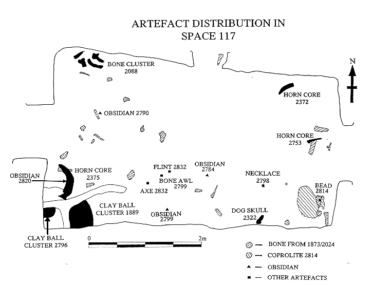
Figure 10: Plan of Space 117, Artefact distribution (drawn by C.Cessford)
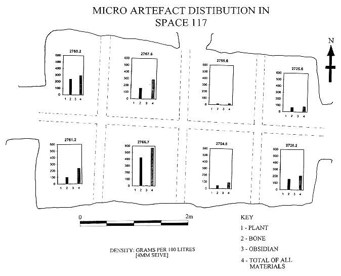
Figure 11: Plan of Space 117, Micro-Artefact distribution (drawn by C.Cessford)
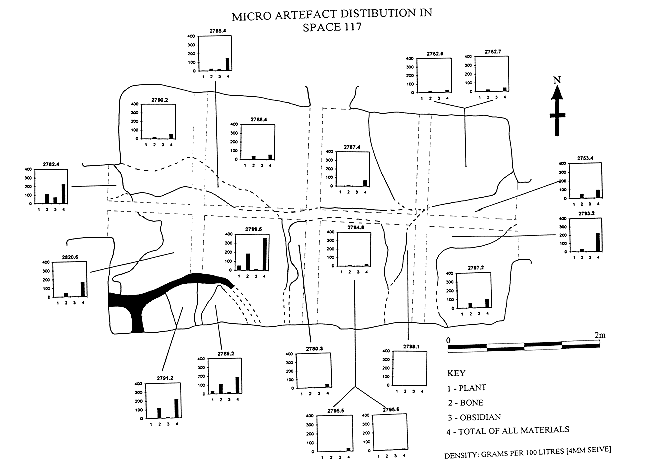
Figure 12: Plan of Space 117, Micro-Artefact distribution (drawn by C.Cessford)
| |
© Çatalhöyük Research Project and individual authors, 1997