ÇATALHÖYÜK 2005 ARCHIVE REPORT
| |
EXCAVATIONS
Introduction
Shahina Farid
Areas of Excavation 2005
Excavation took place in four areas on the East mound, and one off-site in 2005 (Fig. 11). The four areas on the mound were: 4040 Area, an area that was scraped in 2003 on the northern eminence of the mound; the TP Area, an area excavated by Team Poznań since 2001 at the crest of the mound; the South Area, an area excavated since Poznań since 2001 at the crest of the mound; the South Area, an area excavated since 1995, incorporating the 1960s trenches and covered by a shelter constructed in 2002, and a new IST Area on the lower southwest slope, south of the South Area. Off site a new programme of work is conducted by a team from Selcuk University.
The areas and structures within each area were targeted with specific aims for this current phase of excavation.
Figure 11. Areas excavated on the East mound in 2005. |
Excavation Teams 2005
4040 and South Area Teams
Under direction of the Project excavation teams in for the 4040 and South Area excavations 2005 comprised contract excavators employed from the UK, Turkey, the US and Romania and assisted by field schools from Stanford University and UC – Berkeley – US, individuals were funded from the University of Cambridge, Institute of Archaeology, University College London – UK, Middle Eastern Technical University – Turkey and Tehran University – Iran. The aim is always for students to work along side professional excavators to gain a good and thorough grounding in excavation skills, recording and integrated interpretation. Excavation teams are therefore grouped based on experience with specific aims for the seasons work accounted for.
TP Area Team
The team from Poland, headed by Professors Lech Czerniak and Arkadiusz Marciniak from the Institute of Archaeology and Ethnology, Polish Academy of Sciences and the Institute of Prehistory, University of Poznan direct a team of students from Poland. The TP team have worked in an area at the southern crest of the East mound since 2001 to study the latest phases of tell occupation, dated to the end of the seventh millennium BC and located next to the 1961 trench where James Mellaart had defined Levels I – III.
IST Area Team
Team IST is mainly comprised of members and students from the University of Istanbul, Department of Archaeology, Prehistory Section under the direction of AssocProf.Dr.MihribanÖzbaşaran.Assoc Prof. Dr. Mihriban Özbaşaran.
Team IST has formerly excavated sites in Central and Southeast Anatolia. Since 1989, its members have been working at Asikli Höyük and Musular, the two Aceramic Neolithic sites located in the east part of Central Anatolia - west Cappadocia. Aşıklı and Musular, respectively, are the predecessors of Çatalhöyük in chronological terms. Aşıklı is radiocarbon dated to the 9th-8th mill. and the latter to the 8th-7th mill. BC. With such a background, Team IST aims to focus on the early/earliest development of the site. The most promising and the suitable area to fullfill this objective of excavating the early phases of the settlement in large areas is the southwestern slope of excavating the early phases of the settlement in large areas is the southwestern slope of the mound.
SEL Area Team
It has long been known that a classical site lies to the southeast of the East mound beyond the site perimeter fence (Fig. 11) between the designated 1 and 3 listed areas. Under the direction of Prof. Dr Ahmet Tırpan , Dr Asuman Baldıran and Arş. Gör Zafer Korkmaz led a field team from the Dept. of Archaeology, Science and Literature Faculty, Selçuk University in its first year of a five-year project in which to investigate these historic sites.
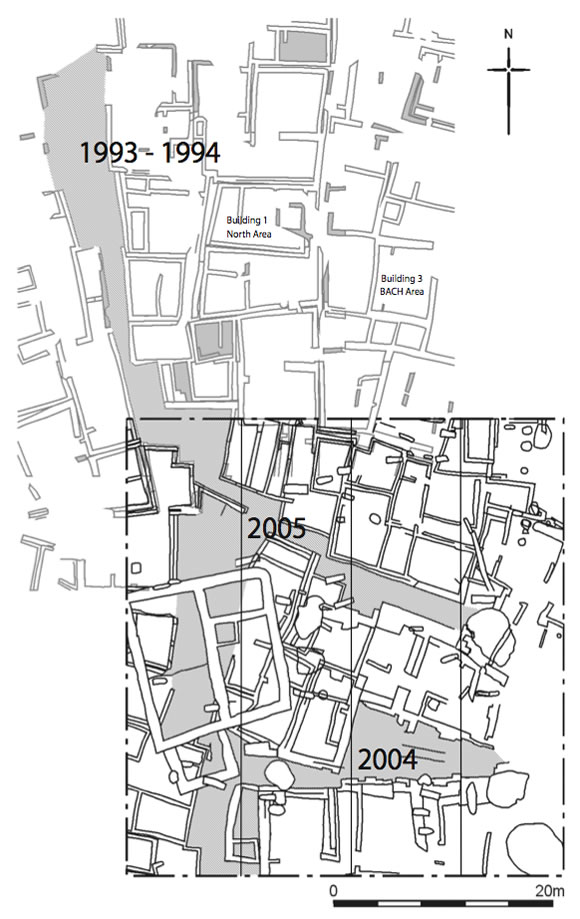
Figure 12. Integrated scraped areas 1993 - 1994 with 2003. |
5-year excavation and research programme
In terms of the aims for the current 5-year phase of the project (2003-7) deal with the social geography of the settlement and larger community structure. We aim to answer questions on: how were production, social relations and art organised beyond the domestic unit? How did this organisation develop over time? Does the social geography of Çatalhöyük involve groups of houses clustered around dominant houses or is all social and economic life decentralised and based on equivalent domestic units of production?
In order to address these questions we moved away from detailed analyses of individual buildings, their construction, occupation and closure, which were the focus of the previous 5-year phase of work (1995-99, see forthcoming volumes), and we concentrated on large ‘neighbourhood’ areas.
4040 Area
Thus the 4040 Area to the north of the east mound was scraped in 2003 and integrated with the area exposed by surface scraping in 1993-5 (Matthews 1996). This exposed a large number of houses that defined groups of similarly aligned Neolithic houses possibly separated by ‘streets’ or ‘alleyways’ (Fig. 12).
The aim is to excavate as many buildings within the 4040 Area to their latest occupation horizon and to cover the area with a structure that will be open to visitors throughout the year, as well as providing cover for the archaeologists to continue excavating in the summer months (see South Area shelter). The next phase of work will then target specific buildings and spaces covering a range of building type and date.
Accordingly, excavation in 2004 examined a 10x40m strip straddling a number of ‘zones’ of structures separated by ‘streets/alleys’. Preliminary results of the season indicated that in fact the 10x40 strip straddled different Neolithic occupation periods, ‘levels’. Based on the pottery and chipped stone assemblages it showed that the latest structural activity attributed to Level IV – III was located in the central cluster of buildings, then Level V-IV in the southern most cluster of buildings and the earliest Level VI or later in the northern zone of buildings. The ‘steets’ were mostly midden deposits and may in fact be the result of temporal shifts in areas of occupation and midden discard around zones of housing.
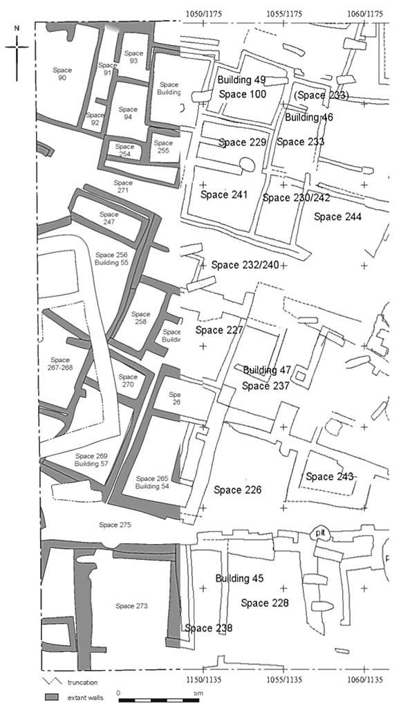
Figure 13. 10x40 strips excavated in 4040. 2004 to the right and 2005 to the left. |
The aim of the 2005 season was to continue exposing the last phase of buildings in the 10x40m strip to the west of the area excavated in 2004. The SW co-ordinate of this year’s targeted strip was 1140/1135 (Fig.13). Excavation in the 4040 Area commenced on 4th July and ended 10th August. Due to the short season and fewer contract excavators the intention was to excavate all historic intrusions and define and excavate the backfill of all buildings to expose the last phase and internal configuration, to gauge a basic stratigraphic sequence of the buildings and place them within the results from last year. Minimum occupation deposits were excavated.
Under the supervision of Doru Bogdan and Lisa Yeomans excavation commenced from the north working southwards. As such buildings of different Levels were under excavation at the same time. The complicated nature of construction sequences and Levels was clearly illustrated even within defined clusters of contemporary buildings. The results however, concurred with the findings from last year, that the area is divided into three zones of buildings representing different periods. Overall there was a paucity of artefacts by which to date the buildings but the little retrieved matched the results from 2004. Thus the earliest buildings lie to the north, attributed to Level VI and possibly earlier, however even within this small cluster of buildings at least three construction phases are identified. The earliest lies to the west, represented as Space 90, then Building 52, consisting of 6 possible spaces, Spaces 91, 92, 93, 94, 254 and 255, and the latest construction is Building 51, Space 98.
Although only the historic sequence over the southern most sector of buildings was excavated, based on results from last year we can assume that the period represented in this area and is equated to Level IV- V.
Consistent with last years results therefore the central cluster of buildings are attributed to Levels II – IV, on the basis of B47 and its relationship to Space 227 which was further expanded into this season. So, it appears that Building 58 (from the west) comprising Spaces 227, 258 and 274 is later than Building 47 (excavated in 2004), which appears to be contemporary with Building 55 (Spaces 247 and 256) and Building 57 (Spaces 269 and 270). Later, and therefore possibly contemporary with Building 47, is Building 54 (Spaces 264, 265 and 266), as its walls overlie those of Building 58 to the north and Building 57 to the west. Immediatelytothenorthofthe4040Immediately to the north of the 4040 Area, Buildings 1 and 3 have been dated to Level VII – VIII (Forthcoming Volume 3), although their chipped stone and pottery components suggest Level VI, similar to what we see in the northern-most zone of the 4040.
There is no reliable dating material from the ‘open’ areas that delineate the clusters of buildings discussed where ‘open’ areas that delineate the clusters of buildings discussed where minimal excavation was conducted this season. They would be later than or contemporary with the central cluster of buildings consisting of layers of accumulated domestic waste. To the south Space 275 is a continuation of Space 226 excavated in 2004, and to the north Space 271, a continuation of Spaces 232/240 also excavated in 2004. These ‘open’ areas were initially presented as streets between discrete blocks of buildings when first exposed through surface scraping in the 4040 Area in 2003 (ref 2003 archive).
South Area
To compliment our research aims in the 4040 Area covering contemporary neighborhoods, in the South we aim to explore more fully the temporal processes that produce phases of settlement because the buildings remaining from the Mellaart and our excavations occur at different levels. Thus it is possible to examine the chronological development of houses in relation to each other from the very base of the mound. We also work towards expanding the area where we reached natural lake marl in 1999 (Farid 1999 Archive Report). This requires strategic planning of where and to what depth to excavate in order to achieve this in a safe and coherent manner. The trench where natural was reached in 1999 falls in the centre of the South Area. In order to extend this trench we need to excavate surrounding structures in a stepped manner. Therefore, in order to reach our ‘natural’ target we have first to move further away from that focal point, but whilst doing so we will be fulfilling the aim of excavating a temporal sequence.
Therefore continuing on from last year we concentrated on excavation of two of the buildings that occupy the highest sections of the area. Work began on the 4th July and ended 10th August.
To the east, in an area previously known as the Summit Area, excavation of Building 44, currently dated to Level IV-V was concluded and the earlier (underlying) Building 56 of Level V was defined. This building is located over a large section of stratigraphy, which we hope to reduce over the course of the next few years.
The second building excavated was located to the centre of the south side where Building 42 of c. Level V was excavated last year. It was from this building that a painted plastered skull was found buried, cradled in the arms of a woman against her chest and a marble figurine retrieved from another feature (2004 Archive Report). The earlier sequence excavated this year, below Building 42, consisted of a midden area and part of a building (Building 53). Notably this earlier building has so far reflected none of the exceptional features of its successor. Absence of continuity is also conspicuous in the fact that the two buildings were not directly superimposed, which is perhaps associated with the use of the area for midden.
TP Area
The team from Poznań, Poland, continued excavations at the highest point of the East Mound (see Fig. 11). This area was targeted to investigate the latest levels of the site, which were neither represented in our excavations on the northern eminence of the mound nor in the South Area. TP Area is located immediately to the east of where Mellaart had excavated Levels I-IV (Farid 2000). The area proved to be heavily utilised in the historic period overlying the latest Neolithic levels, which have been identified as Levels 0 – II by linking the TP trench with the 1960s trench and joining buildings from both excavations. The aim is to continue to explore the later Neolithic sequence expanding westwards. The study of these later periods is providing significant data for the transition of Neolithic to Chalcolithic at Çatalhöyük and thus linking work on the both the east and west mounds.
In addition to the above on-going excavations the first reports of the new areas, IST and SEL are reported below and whilst IST are focusing on the very earliest occupation of the site, SEL are working on the latest.
| |
© Çatalhöyük Research Project and individual authors, 2005