ÇATALHÖYÜK 1999 ARCHIVE REPORT
    |
Excavations in the KOPAL Area
KOPAL Alanı Kazıları
Peter Boyer
Abstract
A six week period during August and September 1999 was spent excavating a trench to the north of the east mound at Çatalhöyük in order to gain information about the off-site geomorphology of the site. 3m of sediment was removed by machine. A further 1m of material was excavated by hand in an area 8m x 8m, to natural.
A sequence was exposed, which revealed 20cm of ploughsoil overlying c. 2m of alluvium, of an Early Bronze Age and later date. The alluvium sealed a buried land surface, which contained finds suggesting a Late Neolithic/Early Chalcolithic date for this layer. Below this were a number of soil-forming deposits. These sealed a backswamp clay deposit, up to 0.5m deep. The backswamp clay sealed archaeological layers. As excavation continued it became clear that these archaeological deposits filled a number of intercutting pits, which also cut the underlying lake marl. These deposits were rich in animal bones and fired clay objects, though no pottery was found below the backswamp clay.
The sequence exposed suggests two phases of prehistoric activity in the area. The lowest phase consisted mainly of the cutting and infilling of small pits. This activity appears to have been contemporary with early Neolithic activity on site. After a long period of inactivity off-site there appears to have been a later phase of use during the late Neolithic/Early Chalcolithic.
Özeti
1999 Ağustos ve Eylül aylarında altı aylık süre boyunca ,yerlesim alanı dışından jeomorfolojik bilgi edinmek açısından, batı Çatalhöyükun kuzeyindeki açmada çalısmalar sürmüstür. İlk 3mdeki bos toprak dozerle atılmıstır. Daha sonra, 8x8lık açmada 1m asağıya inilmistir.
2mlik alüvyon toprak üzerindeki20cmlik islenmis toprak Erken Tunç Çağına daha sonraki geç dönemlere ait toprak olduğu gibi bırakıldı. Alüvyon, buluntulardan anlaşıldığı üzere Geç Neolitik/Erken kalkolitik olduğu düşünülen tabakaları kilitlemis.Bunun üzerinde toprak brikimi mevcut.Bunların, 0.5m derinliğinde bataklıklaşmış bir kil çökeltisini kilitlediği gözlenmistir.Bu bataklıklaşmiş kil tabakası da arkeolojik tabakaları kilitlemiştir. Kazı devam ettikçe bu arkeolojik tabakaların, açılmış çukurlarla dolu olduğu görüldü. Bu çukurlar aynı zamanda gölün dipindeki marnı da kesen çukurlardır.Bu tabakalar hayvan kemiği ve pişirilmiş kiltoplar bakımından zengin olmasına rağmen, hiç çanak-çömlek buluntu vermemiştir.
Bu durum bu alanda iki prehistorik aktiviteyi öneriyor. Erken tabakalarda temel olarak küçük çukurlar açma ve doldurma işlemleri yapıldığı gözleniyor.Bu işlem yerleşim yerindeki erken Neolitik tabakalarla bağlantılı görünüyor. Yerleşim dışı aktiveler uzun süre devam ettikten sonra aynı şekilde yerleşim dışı aktivitelerin geç tabalarda yani geç Neolitik ve Kalkolitik tabakalarda da devam ettiği görülüyor.
Introduction
In the past few years the geomorphological environment around Çatalhöyük has been studied in some detail and it has been possible to place the site within a broad geoarchaeological context. Recent work (e.g. Boyer, 1999) has enabled the reconstruction of the geomorphological history for the area of central Anatolia in which Çatalhöyük is situated. The site is located on a broad alluvial fan on the Konya Plain in South-Central Turkey. During the later Pleistocene this region was occupied by a large shallow lake, which appears to have periodically had rivers flowing into it, as evidenced by layers of deltaic sand. As the lake dried during the terminal Pleistocene so lake marls were exposed across the lake basin, forming a broad, flat plain. During the early Holocene rivers began to flow from the higher ground around the plain and deposited sediments in the form of alluvial fans around the edge of the plain. The largest such fan was formed at the south of the plain towards the western end of the former lake basin, and was created by the Çarşamba River which flowed down from the Taurus mountains situated to the south. Systematic coring and exposed sediment recording has enabled the reconstruction of the late Quaternary sedimentary sequence across the Çarşamba alluvial fan. At Çatalhöyük the base of this sequence consists of white lake marls which are sometimes interrupted by layers of Pleistocene deltaic sands. Above the marl about three metres of alluvium have been deposited since the early Holocene. This alluvium can be divided into two broad units. The basal c. 1.5m consists of a very fine dark grey swelling backswamp clay. This was the unit being deposited during the occupation of both the east and west mounds at Çatalhöyük and possibly also for some time afterwards. There then appears to have been a hiatus c. 6500 - 4500 BP after which there was a change to a different alluvial regime. This is represented by c. 1.5m of a coarser, paler and more reddish alluvial unit which was naturally deposited until canalisation of the Çarşamba River in the early 20th century. It is believed that the change in the alluvial regime may have been due to detrimental effects on the environment caused by Early Bronze Age and later deforestation in the Taurus Mountains. The two different alluvial types have been referred to simply as Lower Alluvium and Upper Alluvium. The basic natural sedimentary sequence around the site therefore consists of three general units; lake marl overlain by Lower Alluvium overlain by Upper Alluvium, and is the sequence that would be expected where there was no archaeological activity.
In 1997 as part of ongoing work relating to site-formation processes carried out by members of KOPAL (KOnya Plain PALaeoenvironmental Project), a trench was excavated in the field to the north of the east mound, directly north of the North Area excavation (Merrick et al. 1997). Because of the depth of stratigraphy, the trench was stepped, 1m in for every 1m increase in depth, to give a basal working area at 3m depth of c. 5m north-south, by c. 1.2m east-west, c. 20m to 25m north of the northern periphery of the mound. Cleaning of the west-facing section of this trench revealed not a simple threefold stratigraphic sequence as outlined above, but an upper c.2m of ploughsoil and Upper Alluvium overlying a number of thinner layers apparently representing phases of soil development. The upper and clearest of these layers (2410) has given an uncorrected 14C date of 7320 ± 80, suggesting a calibrated date in the Late Neolithic. Below these layers was up to 0.75m of heavy backswamp clay or Lower Alluvium. Smaller sondages below this revealed not more backswamp overlying marl, as had been expected, but cultural material overlying marl, interpreted as the fill of a pit or ditch cut into the marl. Thus rather than exposing a full and clear alluvial sequence, the 1997 excavation revealed two phases of prehistoric activity separated by backswamp clay, with the later phase buried by more recent alluviation.
As part of the 1999 six month excavation season at Çatalhöyük it was decided to re-open a larger off-site trench in the same area as the 1997 excavation and encompassing part of that excavated area. The aims of the 1999 KOPAL trench were to expand upon the findings from the 1997 trench and were essentially threefold. Firstly it was intended to gain an increased understanding of the sedimentary sequence in the area adjacent to the site. The full sedimentary sequence exposed in 1997 had only been recoded in a very limited area and had clearly shown a natural sedimentary sequence interrupted by cultural episodes. By expanding the area excavated, it was hoped to gain a fuller understanding of the relationship between natural and cultural sediments, and hopefully to identify a more complete natural sequence. Secondly, it was hoped the excavation would enable the further identification of evidence of off-site cultural activity and relate this to activity on the mound. Thirdly, it was also hoped to assess the level of waterlogging (if any), of deposits in this area. In the lower deposits excavated in 1997 there had been apparent pockets of waterlogged material so it was decided to extend the waterlogging assessment in the South Area to the northern off-site locale.
Methodology
Machine excavation of the trench began on 1st August 1999, and initially involved the removal of the upper c. 1.2m of material in a 12m x 12m area (SW corner at 1043/1335 on main site grid), with a ramp excavated to the north of this for machine access. Within this a further c. 1.2m of material was also machine excavated in an area c. 10m x 10m. The machine was also utilised to excavate a third step c. 8m x 8m to a depth of c. 0.6m, thus giving a basal working area of c. 8m x 8m at a depth of c. 3m from the current land surface. Machining progressed very quickly and was completed in one working day. However, accuracy was sacrificed for speed in some respects, and so hand straightening and cleaning of the trench edges and sections was necessary for some days afterwards. As each step was cleaned and straightened, so the west-facing section of that step was recorded by drawing and sediment description, in order to give as complete a recorded sequence as possible, and as soon as possible, before sediments dried out, prior to cleaning and excavation of the base.
The top step of the trench (0 - 1.2m depth) consisted of a layer of ploughsoil (6000), up to 0.20m deep, overlying a layer of dark greyish brown, compact alluvium (6006), up to 0.42m thick. This overlay a more friable orange alluvium, up to 0.32m thick (6007). Below this lay a firm, grey alluvium (6008), up to 0.40m thick and a firm, dark greyish brown alluvium (6083). This latter unit continued down into the second step and was up to 1.30m thick. The units down to this level made up what has previously been described as Upper Alluvium (see above).
In the second step of the west-facing section there was a clear contrast between the base of (6083) and the material below (6003). This latter unit was a mixed silty deposit ranging in colour from dark olive brown to pale yellow, the latter apparently being predominantly carbonate lenses. Significant quantities of pottery and animal bone were observed on the surface of this unit and within the main unit body. A partly-complete pot was found sitting in situ in the top of the unit. It was therefore assumed that this may have been some type of buried land surface. Later cleaning and sampling of this layer also revealed what appeared to be an in situ, double-phase fire installation feature, also sitting on the surface (see below). Below (6003) in the west-facing section lay a slightly friable layer of dark greyish brown alluvium (6020), up to 0.30m thick (though later seen to consist of a number of different layers, see below). This contained some cultural material and overlay a layer of orange-brown alluvium (6004), up to 0.14m thick. Below this was a thick (up to 0.5m) layer of homogenous dark grey backswamp clay (6001/6005). This appeared to be an almost totally natural alluvial deposit with very occasional cultural elements, which were probably part of a small colluvial input to the deposits.
The possible buried land surface (6003) and the underlying layers (6020 and 6004) were not extant across the whole trench however. In the east-facing section, (6083) was seen to directly overlie (6001/6005), much in the same way as Upper Alluvium directly overlies Lower Alluvium as described previously (e.g. Boyer, 1999). A feature cut into the top of the backswamp clay (Fill 6027, Cut [ 6026] ) was recorded in this section, and appears to have been Late Neolithic/Early Chalcolithic in date.
Across much of the trench the base of the backswamp clay was not reached during machining, but was bottomed during cleaning of the base of the trench. All layers below the backswamp clay were excavated by hand.
Below the backswamp clay lay a large spread of material, originally interpreted as a mixed alluvial/colluvial deposit (6010). However, it was soon realised that large pieces of animal bone and other cultural materials were present in this deposit, which were unlikely to have been transported entirely by colluvial action. The unit also appears to have been the same as (2412) recorded in 1997, and described as a possible ditch deposit. The earlier excavation however, had only recovered this deposit in a very small area, whereas (6010) extended across the whole 8m x 8m area of the 1999 trench. With no clear edges, the deposit was interpreted as a general layer of dumped material.
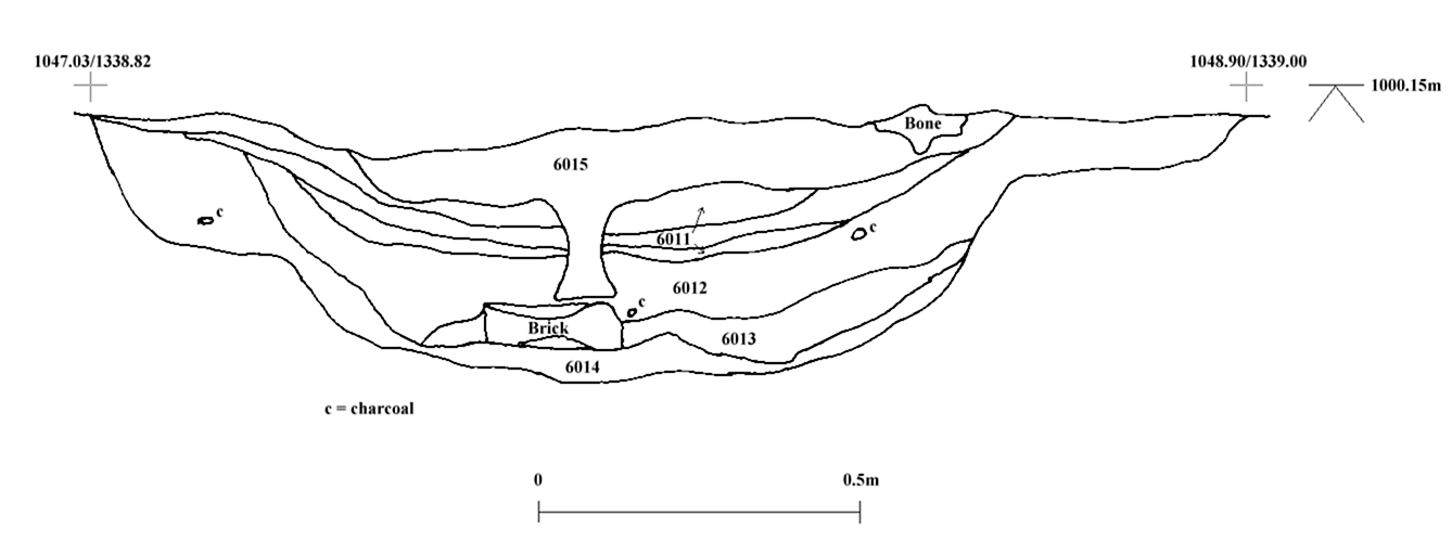
Cut into the top of this unit was a clear pit-like feature (F650, Figure 20) which was sealed by (6001/6005). This was a small shallow pit, irregular in both plan and profile (Cut [ 6016] ). The upper, central fill of this was a dark grey clay (6015) and overlay three generally ashy layers, though these were grouped together as one (6011), not having been recognised as separate layers until the section was exposed and cleaned. Below this was a thick greyish deposit with some carbonised material and a large concentration of phytoliths (6012). This lay above a thin, dark band of material (6013), which had an apparently high organic content and contained large brick fragments, and lay above the basal fill of the pit (6014), which was a grey clayey layer, not dissimilar to the general deposit, (6010) through which, the pit was cut. F650 thus appears to have been the latest pre-backswamp feature in the area excavated.
As (6010) appeared to be quite a thick deposit, showing little variation across the trench, it was decided to excavate this material in spits, (6010) being the unit number given to the upper c. 0.1m covering the whole trench. Removal of this spit revealed two further features.
The first of these was a small, round cut feature, observed towards the north-west corner of the trench and extending into the east-facing section. This was first described as a small pit (Cut [ 6023] ), with a homogenous, loose, dark greyish brown fill (6022). Further investigation however, revealed the feature to be much deeper, consisting of two further fills (6072, 6075), both being very similar dark greyish brown clays. The cut (also given a new number, [6074] ) was found to extend to a depth of c. 0.6m, through archaeological deposits and into natural marl and sand layers. This was quite vertical with a flattish base, and was thus interpreted as a post-hole. No further such features were found during the course of excavation, so it was assumed that, unless this was an isolated feature, any larger structure must have lain to the north or west of the area excavated.
The second feature revealed following the removal of (6010) was an oval pit in the south-east quadrant of the trench. This measured 1.2m north-south by 0.96m east-west. A fragment of human skull was found in the top of the fill (6018), and it was initially thought the feature may have been a burial. However, excavation revealed no further human remains and a cut [ 6019] , 0.39m deep with gently sloping sides and a flattish, rounded base. The feature cut through cultural deposits and into the underlying natural marl and sand layers, and had itself been partly truncated during the 1997 excavation.
A second spit (6021), up to 0.15m thick was removed in the western half of the trench in order to level up the basal excavation area. This material was essentially the same as (6010), though with slightly more carbonised plant remains. It was cut by [6023/6074] and overlay a small, squarish lens of yellowish brown material (6024), the nature and function of which, was unclear.
The next spit of general fill was given two unit numbers ((6025) for the northern half of the trench and (6028) for the south) in order to gain some spatial control over the finds recovered. The material was a very dark grey, compact silty clay, and like the deposits above, contained large quantities of cultural material, particularly animal bone and fired clay objects. A spit c. 0.05m deep was removed across the entire trench. Following the removal of this spit it was decided to further refine the spatial control over the trench by dividing the underlying spit into six spatially variable units by splitting the northern and southern halves of the trench into three. Thus below (6025) lay units (6029), (6030) and (6031) and below (6028) lay (6032), (6033) and (6034). A spit of c. 0.1m was removed, and again consisted of a very dark grey, compact silty clay with abundant cultural remains. Two thin lenses of organic material (6035, 6036) were also recorded at the base of this spit. There was still however, negligible variation in the material present across the trench and so a further spit was removed, again divided spatially into six units (6037 - 6042). This spit was 0.05m thick and consisted of similar material to those above, though with increasing patches of re-deposited lake marl. Furthermore, removal of this spit revealed more cut features, and for the first time, the exposure of extant natural deposits.
The first feature identified was a large, irregular pit in the north-east of the trench. This consisted of a 0.2m thick layer of homogenous dark greyish brown silty clay loam (6044), with moderate cultural remains, overlying a 0.15m thick layer of what was predominantly re-deposited lake marl, with minor alluvial and cultural elements (6053). These units filled a large, irregular cut [ 6055] , 1.92m north-south by at least 1.46m east-west, and extending into the west-facing section. The cut was up to 0.4m deep and had irregularly sloping sides and a flattish base. It had cut directly into lake marl in an area of the trench where the marl had survived to its highest elevation (c. 1000.10m), with no sign of lower, cultural layers having been truncated.
The second feature identified at this level was a moderate-sized, irregular, elongated pit (Cut [ 6046] ), measuring 1.15m north-south, by 0.5m east-west, and up to 0.16m deep. It was cut through lower cultural materials into underlying lake marl, and filled with a compact, dark grey silty clay (6045), containing some cultural materials, but a lower re-deposited marl content than surrounding deposits. It lay towards the north-east corner of the trench.
A third feature observed at this level was a moderate oval pit in the north of the trench, with the cut [ 6056] measuring 1.35m east-west by 0.55m north-south (and extending into the northern section) and up to 0.26m deep. It cut through cultural material into marl and was backfilled with a firm, dark grey silty clay with some re-deposited marl (6054).
The latter two features had been cut into the next spit of general fill material, which was again divided spatially into six units (6047 - 6052). This final spit was removed to a much deeper level as it became clear at this point that features clearly cut into underlying natural deposits were becoming apparent. It was decided to remove the remaining general fill over the whole area to expose what emerged as a concentration of features cutting natural deposits across the trench. Thus, up to 0.24m of deposit was removed in places as part of this final spit. Removal of the spit revealed a further twelve features, clearly cut into the underlying lake marl and sand deposits. These can be briefly discussed, starting with the north-west corner, and moving clockwise around the trench:
Cut into the lake marl against the western section in the north-west quadrant of the trench was a small irregular feature (Cut [ 6077/6085] ), measuring up to 1.2m north-south by more than 1m east-west and up to 0.3m deep, with gently sloping sides, and filled with mixed alluvial, cultural and marl materials (6073). East of this were three small features, all with apparently the same fill (6079), which was a firm, dark grey, very clayey material, and consisted of large numbers of animal bones. The first cut [ 6080] was a small (c. 0.45m diameter), almost circular feature, about 0.16m deep, cut through marl and into the underlying sand. To the east of this was the largest of the three cuts [ 6081] , which was broadly oval in plan, measuring 1.92m north-south by 1.72m east-west and 0.48m deep with gently sloping sides and a rounded base. It was cut through marl and underlying sand into a lower, clayey deposit. It was within this cut that the fill exhibited the greatest concentration of finds. To the east of this was the third cut [ 6082] , which was another small, circular (c. 0.5m diameter) pit, 0.2m deep and cut into sand.
Towards the eastern-central part of the excavation area was a small irregular pit (Cut [ 6066] ), measuring 0.78m north-south by 0.5m east-west, with a maximum depth of 0.13m. It was thought at the time of excavation that this may have been the base of a deeper feature cut from a higher level, though not seen until after the removal of the last general spit. The fill (6065) was a firm, dark greyish brown silty clay, with occasional small bones present.
Just to the east of this feature was a small oval pit (Cut [ 6058] ), measuring 0.5m north-south by 0.42m east-west and 0.18m deep, cut into the sand, and filled with a mixed clay, marl and sand fill (6057), with occasional bone.
Close to the southern section, in the south-eastern quadrant of the trench lay a moderate-sized irregular feature (Cut [ 6060] ), measuring 1.15m east-west by 1.10m north-south and up to 0.23m deep, cutting into sand and filled with a firm, dark greyish brown silty clay, including abundant cultural remains (6061). Just to the south-west of this feature was another small cut [ 6071] , irregular but becoming slightly triangular in shape, and measuring 0.56m north-south by 0.54m east-west and up to 0.11m deep, again filled with a dark clay with some cultural material (6070).
Lying to the north-west of the two previous cuts, in a position quite central to the excavation area, was another large, irregular pit (Cut [ 6064] ). This was 1.6m north-south by 1.25m east-west and up to 0.22m deep, and although irregular in plan at the top, had a more regular, flat, oval base, and was cut into sand. The feature was filled with a firm, dark greyish brown clay (6059) and although this contained fewer finds than the overlying general fill, clearly included a cultural element. Immediately to the south-west of this feature was another irregular shaped pit (Cut [ 6063] ), 1.6m east-west by 1m north-south, and 0.58m deep, cut well into deltaic sand. It had vertical sides and a flattish base, and a predominantly sandy clay fill with some marl and silt (6062). Some animal bone was present.
At the southern end of the trench, against the southern section in the south-west quadrant, was situated another small, irregular pit (Cut [ 6067] ), measuring 0.82m east-west by 0.34m north-south, though only 0.03m deep, with a soft clay fill (6068) containing a small amount of cultural material. Again, this may have been the base of a feature cut from a higher elevation but not previously seen.
Finally, a large, shallow, sub-rectangular feature (Cut [ 6076] ) was recorded on the western side of the trench, being orientated approximately north-west - south-east, and continuing into the western section. About 2.3m of the length of the feature was exposed and it was about 1.5m wide. It was only 0.15m deep from the level at which the cut was recognised, having truncated the marl but stopped at the top of the underlying sand. It was thought at the time of excavation that this may have been a natural feature, though the fill had a very definite cultural element, consisting of abundant waste (bones, clay object fragments etc.) in a firm very dark grey silty clay matrix (6069).
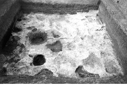
In addition to all of these clear features there were numerous small undulations in the top of the natural marl such that once the entire trench was excavated down to natural, a marl surface was exposed, which had been heavily scarred by multiple truncations, some pits having just been dug into the marl, others clearly dug through the marl and into the underlying sand (Figure 21). Once the excavation of the main area was finished, the drawing of the lower west-facing section was also completed down to natural so that all units and features were recorded.
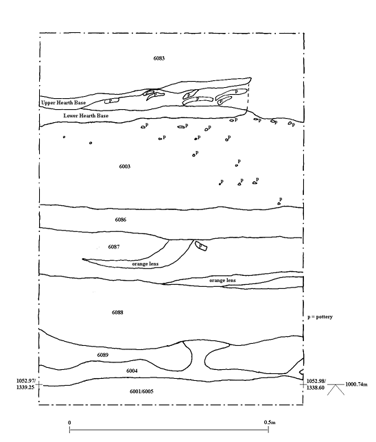
One final element of excavation involved a more detailed study of the sedimentary sequence exposed in the west-facing section, between the alluvium (6083) and the backswamp clay (6001/6005) (Figure 22). Initial cleaning of this sequence had shown a possible buried surface (6003) underlying (6083). This then overlay a thick mixed deposit (6020), which overlay an orange alluvial deposit (6004), which lay above the backswamp clay. More detailed cleaning and recording revealed that (6020) could be divided into four different units. The upper of these (6086) was a 0.08m thick dark band of silty clay material, directly comparable with (2410) recorded in the corresponding section in the 1997 trench, and interpreted then, as now, as a possible buried soil horizon. Below this lay a 0.12m thick layer of firm, dark greyish brown silty clay (6087), which contained some intermittent orange bands. This appears to have been a thin alluvial deposit. Under this lay a thicker (0.17m) dark band of firm, silty clay material (6088), again interpreted as a possible buried soil horizon. This overlay a 0.09m thick layer of firm, dark brown silty clay (6089), again interpreted as alluvium. Below this was (6004). This cleaning also revealed more detail in (6003). Initial cleaning had exposed the in situ pot in the top of this unit, towards the northern end of the section and moderate numbers of sherds throughout the unit. Cleaning and sampling of the detail section revealed a fire installation feature in the top of (6003). This consisted of a lower hardened base overlain by a quantity of crushed pottery and sealed by another apparent fire installation base, adding support to the idea that (6003) was a buried occupation horizon.
At no time during the excavation were any units excavated that appeared to be in any way waterlogged. Any pockets of waterlogging that were apparent in 1997 had disappeared by the 1999 excavation season.
All work on site was completed by 15th September and paperwork finalised on 16th September.
Sampling
During the course of excavation, sampling was carried out in more or less the same manner as on site, with archive and flotation samples taken as routine for every unit excavated. Other, specialist samples such as phytoliths and organic residue were also taken as necessary. Because of the possibility of waterlogging, extra samples were also taken for wet sieving from most units below general spread spit (6010). As up to 4m of stratigraphy was exposed, a number of samples were also taken up the exposed sections to enable the analysis of a controlled temporal range of materials, thus a number of micromorphology samples were taken from all sections and a sequence of phytolith samples was taken up the west-facing section. Up to, and including the excavation of (6010), material was not generally dry sieved, as it was thought that the high clay content of the deposits would prevent effective sieving. From the excavation of (6021) onwards, dry sieving was practised as it was realised that the material was suitable for the process. A sequence of overlapping monolith samples was also taken up the west-facing section from the base, into the Upper Alluvium (6083), thus including the lower cultural deposits, the overlying backswamp clay, buried soil/occupation horizons above this, and the lower levels of the Upper Alluvium.
Discussion and interpretation
A chronological sequence of activity can be reconstructed for the area covered by the 1999 off-site excavation. At the base of the sequence there had clearly been quite concentrated truncation of the natural marl as evidenced by the numerous pits cut into and through this material. The highest elevation to which natural, in situ marl survived in the trench was c. 1000.10m whereas over most of the trench there was no in situ material above about 999.70m. Evidence from a core taken c. 150m to the west of the trench (Boyer, 1999 pp 65 - 68) suggested that the surface of the marl lay at c. 1000.50m and was at least 0.6m thick. The marl in the area of the trench therefore seems to have been mostly removed, and it is suggested that quarrying by inhabitants of the mound was responsible for this. Marl was presumably utilised as a building material on the site, and that some of the pits were clearly excavated into underlying deltaic sand, suggests that this material was also utilised for some type of structural purpose. Previous work (e.g. Roberts et al., 1996; Boyer, 1999) has shown that under natural depositional conditions in this area, there would have been a layer of backswamp clay deposited over the lake marl prior to occupation of the site. Indeed, cores through the mound have shown an accumulation of about one metre of this material underlying the archaeological levels. Prior to marl quarrying there must have been a layer of backswamp clay over the marl in the area of the 1999 trench and therefore this must also have been quarried either for use on site, or in order to allow access to the underlying marl.
The material backfilling each of the cuts into the marl was very similar throughout, and also similar to the general fill removed in spits above. This was quite a fine material and probably included an alluvial element. However it also contained high concentrations of finds, particularly fired clay objects and animal bones and therefore also contained a significant cultural element. The animal bone assemblage was of particular interest as it contained large bones from a number of large, predominantly wild animal species, including cattle, boar, red deer and possibly even roe deer. Sheep and goat, which had been the predominant species in many of the on-site assemblages were present in much lower quantities. Interestingly, the animal bone assemblage also included a small but significant amount of human bone, all disarticulated and apparently treated no differently in terms of discard to the other bone. In general the animal bones from the off-site trench are suggestive of post-consumption waste (Frame et al., this volume). The chipped stone assemblage was also dominated by finished objects rather than showing any evidence of in situ manufacture (Carter, this volume). The overall material assemblages from a number of units were very similar to those recovered from the lower levels in the deep trench in the South Area on the mound. Like all units below the backswamp clay off-site, these deposits were totally lacking in pottery and because of their stratigraphic position suggest an early, pre-pottery phase of the site. The off-site deposits appear to have been approximately contemporary with these assemblages. Carter (this volume), suggests that the chipped stone assemblage in the lower KOPAL levels has more affinities with the later pre-pottery layers in the South Area, rather than those at the base of the sequence. A significant element common to both KOPAL and South Area assemblages was the large number of fragments of fired clay objects, and in some instances, complete objects. These variously shaped items appear to pre-date both pottery and clay balls, though some are clearly similar to the balls in shape. Despite their ubiquity, the function of these objects is as yet, unclear (see Suponcic, this volume).
The quarrying activity appears to have continued for some time, as the pits were apparently dug from different levels, the latest having cut into the top of (6010), though because of the similarity in many cases between feature fills and material cut through, it was not always possible to identify the tops of features accurately. A further note must be made here, however, about the nature of F650. This appears to have been the latest feature excavated, prior to backswamp inundation and unlike all of the other pits at this level and below, did not penetrate the natural marl or sand, being dug only into cultural deposits. It does therefore not appear to have been a quarry pit. Furthermore F650 differed from other features by having distinct stratified fills (Figure 20), some of which contained high concentrations of carbonised plant material and phytoliths. The evidence suggests the pit may have been used partly for the deposition of plant processing waste and therefore, that activity other than quarrying and waste deposition took place close to the area of the excavation.
Following the termination of the activity here, the area became sealed by a layer of backswamp clay. This material appears identical to that recognised from earlier work on the natural sedimentary sequence in the area, that was deposited from the early Holocene into the Early Bronze Age. The core discussed above, 150m to the west of the 1999 excavation, records c. 1.6m of this material and it has already been discussed how the earlier deposits of this material must have been truncated in the area of the KOPAL trench. The backswamp clay in the trench must therefore be comparable with the upper levels of the same material from the earlier core. However, the backswamp clay does not mark the termination of prehistoric occupation in the area, as above it are a number of possible buried soil horizons and land surfaces and at least one of these (6003) has exhibited evidence of in situ activity, apparently in the Late Neolithic or Early Chalcolithic. Unfortunately the area in which this activity was identified was very small and it is difficult to draw any conclusions about its exact nature and extent.
The nature of the activity and deposits in the area of the KOPAL trench should allow some determination of the environment at Çatalhöyük prior to, during and after the earlier phase of activity identified in the KOPAL trench. This has been previously discussed (Boyer, 1999 pp 224 - 232), but not in relation to a particular occupation phase. The backswamp clay which was truncated during marl quarrying, and which may have been up to 1m thick, would have been indicative of a very wet environment, with seasonal, if not permanent, flooding of the area. However, for extraction to take place the area must have been relatively dry to allow excavation of deposits. This phase of activity may therefore have commenced during a drier environmental phase than that experienced at the onset of the Holocene. That the backfilled quarry pits appear to contain an alluvial element, and that the fills and general spreads appear to have been mixed, possibly by water action, suggests that there was still some flooding during this phase of activity. This must have been very periodic, probably seasonal and therefore most likely during Winter and early Spring. Quarrying would therefore appear to have been practised during the Summer months. Whether waste deposition was also a seasonal activity is not so clear. Obviously it would have been easier to take waste out into this area during the drier seasons, with the waste being exposed until inundation by Winter floodwaters. However, the general state of the animal bone suggests little exposure with only minimal gnawing by scavengers (Frame et al., this volume). The waste may therefore have been deposited into partly flooded depressions away from the site. This would clearly have entailed some type of access into the flooded area, possibly via a pontoon or quay-like structure. It could be tentatively suggested that the one post-hole (Cut [ 6023/6074] ) identified during the 1999 excavation may have been part of a wooden quay structure built from the edge of the site out into the seasonally flooded adjacent landscape. That all of this early activity was then sealed by more backswamp clay suggests there was a return to a more permanently flooded landscape at this time, the only cultural elements within the clay being small bone fragments, probably derived colluvially from the mound. However, this does not mean an abandonment of the site at this time. All of the deposits sealed by the backswamp clay appear to date to an early pre-pottery phase of the site, though clearly the site was occupied for some time after this. It therefore seems possible that although occupation of the site may have commenced during a relatively dry phase, it must have continued after the onset of wetter conditions.
Above the backswamp clay were a number of less substantial layers interpreted variably as further alluvium and buried soil horizons. Only further analysis will allow a more positive identification of these units. If buried soil horizons were present at this level it would again suggest a drier environment, or at least one stable enough for soil development. Furthermore the pottery from these layers (Last, this volume) and the one 14C date so far available, suggest a Late Neolithic or possibly even Early Chalcolithic date. The (limited) chipped stone assemblage from (6003) and (6020) also suggest affinities with a technology starting in the later Early Neolithic (Mellaart level 6) and continuing into the Chalcolithic (Carter, this volume). Thus quite a considerable period of time appears to have elapsed between the two occupation phases recognised in the KOPAL trench separated by what must have been quite slowly accumulated backswamp clay. This dating adds further evidence to the suggestion that much of the main occupation of the site may have been during the later backswamp phase.
Above the possible buried soil horizons and alluvial layers were more substantial homogenous alluvial deposits, previously grouped together as Upper Alluvium ((2406) in the 1997 KOPAL trench). Previous dating of this material has suggested an onset in the Çatalhöyük area c. 4400 BP and a continuation of deposition into the early twentieth century AD. Again periodic flooding appears to have occurred over this period, though the exact nature of this has yet to be examined in detail in this area. A different alluvial regime to the previous backswamp phase is evident however. From the evidence in section from the KOPAL trench, the dating of the onset of the later alluvial regime would appear to be earlier than previously assumed. The pottery vessel and the fire installation feature in the top of (6003) appear to be Late Neolithic/Early Chalcolithic and are sealed by the Upper Alluvium. If the commencement of deposition of this material was not until c. 4400 BP, this would suggest these elements being exposed for up to 3500 years, which is clearly unlikely. Therefore either the onset of Upper Alluvium deposition must have happened earlier, or an earlier deposit sealing (6003) must have been lost prior to the onset of the alluviation. Dating of the different levels within the Upper Alluvium is difficult as there appears to have been substantial mixing of deposits at various times, probably by ploughing, though there appears to have been little human activity between that in (6003) and the Hellenistic/Roman/Byzantine periods.
Conclusion and Acknowledgements
In general the six weeks of the KOPAL 1999 excavation were very productive. The amount of evidence for the sedimentary sequence has certainly been expanded, compared with that collected in 1997, though unfortunately no extra information has really been added to the natural sequence. However this has been more than compensated for by the level of information concerning off-site human activity that has been gleaned from the excavation. Two phases of prehistoric activity have been identified. The first of these appears to have been quite early and is probably contemporary with the earlier phases in the South Area, also excavated in 1999. The later phase is possibly later than any of the levels so far excavated on the east mound, though further dating, both archaeological (ceramic) and radiometric is still required to confirm this. Importantly this off-site excavation has expanded the known spatial limits of activity at the site, and has raised a number of important issues relating to the function of sites within their landscape. The potential for future off-site work is clear to see.
Unfortunately the third aim of the excavation has produced very negative results. There was no evidence of any waterlogged deposits still being extant in the area excavated (Cohen (1970) having recorded the level of the water table less than a metre from the surface, close to Çatalhöyük, thirty years ago). There did appear to be waterlogged pockets in the lower levels excavated in 1997, and the presence then of an organic pseudomorph (possibly waterlogged) pointed to some level of waterlogging at that time. However this evidence had gone two years later. Recent agricultural activity therefore appears to have had a seriously detrimental effect on the water table and thus the preservation of waterlogged archaeological remains. The wider environmental damage still remains to be assessed.
The immediate aims now are to deal with some of the material sampled from both the 1997 and 1999 KOPAL trenches. In particular the monolith samples taken in each season require sub-sampling and the sediments analysed for a number of physical characteristics in order that any temporal variations in sedimentation may be recognised. Biological sub-sampling is also necessary in order to assess deposits for the presence of key environmental indicators (e.g. pollen, diatoms etc.). In terms of future excavation work, the 1999 trench has exposed a number of possibilities relating to further research into off-site activities at Ç atalhö yü k during at least two phases of activity at the site, with either lateral or longitudinal extension of the 1999 trench potentially providing further information in this area.
That the 1999 KOPAL excavation was a success is all down to an excellent team. Many thanks are due to the excavation team; Åsa Berggren, Serdar Cengiz, Makbule Ekici, Gulcan Gülşen, Elif Kavas, Perihan Kösem, Aslı Kutsal, Serap Özdöl and Andrew Schoenhofer, and to the workmen; Mehmet-Emin, Muarem, Mustapha and Tamer.
Bibliography
Boyer, P. (1999) A Geoarchaeological Approach to Late Quaternary Environmental Change in South Central Turkey Loughborough University: Unpublished Ph.D. Thesis.
Cohen, H.R. (1970) The Palaeoecology of South Central Anatolia at the End of the Pleistocene and the Beginning of the Holocene Anatolian Studies 20, pp 119 - 137.
Merrick, J., Boyer, P. and Roberts, N. (1997) Archive report on work by the KOPAL team 1997 In Hodder, I. (ed.) Çatalhöyük 1997 Archive Report.
Roberts, N., Boyer, P. and Parish, R. (1996) Preliminary results of geoarchaeological investigations at Çatalhöyük In Hodder, I. (ed.) On the surface: Çatalhöyük 1993 - 95. Çatalhöyük Project Volume 1, pp 19 - 40. Cambridge/London: McDonald Institute/British Institute of Archaeology at Ankara.
Figures
Figure 20: South-facing section through pit F650
Figure 21: Base of KOPAL 1999 trench showing truncations, viewed from the south
Figure 22: Detail of small part of west-facing section between 'Upper Alluvium' (6083) and backswamp clay (6001/6005)
| |
© Çatalhöyük Research Project and individual authors, 1999