ÇATALHÖYÜK 1999 ARCHIVE REPORT
    |
Archive Summary for the South Area
Güney Alani Arşiv Raporu Özeti
Shahina Farid with contributions by Craig Cessford
Abstract
This year a six month season took place in the South Area, formerly called the Mellaart Area. The aim was to reach the base of the east mound to assess the effects of the falling water table across the Konya plain on the lower deposits at the site.
The excavation took place over an alignment of buildings previously excavated by Mellaart which he called Shrines 1, 8 and 10.
The watertable was hit at the very base immediately above natural marl which was the base of the early Holocene lake bed. It appeared that the marl had been quarried in the neolithic period prior to the area being used as an off-settlement waste ground. A depth of 3 ½m of occupation debris had accumulated, the lowest appeared to have been reworked by alluvial activity from the ancient river that ran along the western edge of the settlement.
The area was then developed and superimposed buildings of Levels XII to VII were recorded. Levels XII and XI were represented by 'stabling' areas and Levels X to VII were domestic type buildings with similar ground plans and internal arrangement through the successive levels of buildings which generally consisted of two rooms, one large and one small.
The small rooms generally housed plaster bins and were probably used as 'storage' areas whilst the larger rooms were spatially well organised with defined 'dirty' areas around fire installations housed to the south of the room and 'clean' areas of successive plastered floors across the majority of the space. Around the edges of the rooms were platforms, basins and remnants modelled posts .Human burials were found below platforms and floors.
A total of 18 burials were excavated, 13 infants and neonates mostly in baskets and 4 adults and adolescents. One infant was 'adorned' with stone and bone bead bracelets and anklets which was block lifted and is currently on display in the Konya Archaeological Museum.
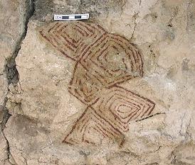
A fragment of wall painting was also excavated with a pattern of concentric lozenge shapes creating a beehive type pattern. The painting is also on display in the Konya Archaeological Museum.
Özeti
Bu yıl 6 aylık proje, eskiden Mellart Alanı olarak adlandırılan Güney alanında yer almıştır. Amac genel olarak Konya alanı, özel olarak da yerleşim alt tabakalarını etkileyen taban suyundaki alçalmanın etkilerini belirlemekti.
Kazı sırasıyla, daha önce Mellartın Tapınak1, 8 ve 10 diye adlandırdığı binalarda sürdü.
Taban suyu, erken Holosen göl yatağının tabanındaki doğal marna ulaşıldığında, en alt seviyesine ulaştı. Görünen şudur ki bu alan neolitik dönemde yerleşim dışı faaliyetlerin yürütülmesi için kullanılmış. 3 ½m yerleşim kalıntısı birikmiş, en altta gözüken, batı kenarındaki nehrin alüvyal aktivite ile yeniden çalışmaya başlaması ile birlikte birikimin oluşmasıdır.
Daha sonra alan geliştirildi ve üst üste olan Tabaka XIIden VIIye kadar olan binalar kaydedildi. Tabaka XII ve XI ahır alanlarının sonucudur ve Tabaka X ve VII, genelde bir geniş ve bir küçük olmak üzere iki odalı, ve iç düzenlemesi ve arazi planı bir olan, ard arda gelen domestik yapılardan oluşur.
Küçük odalar genellıkle depolama için kullanılıp, sıvalanmış depo yerleri içeriyorken, geniş odalar, odanın güney kısmında bulunan, ocak yerlerini çevresinde yer alan iyi organize olmuş, daha önce tanımladığım kirli tabanlarla, odanın genişligine rağmen üst üste sıvalanmıs temiz tabanlardan oluşur. Köşelerde platform ve kazıklara rastlanır. Insan gömüleri platformların ve tabanların altında bulunur.
Toplam 18 tane mezar gömü kazıldı, 13 tanesi bebek ve sepet içinde olarak bulunmuş, 4 tanesi yetişkin ve ergen. Bir bebek taş ve kemik boncuklarla süslenmiş olarak bulundu ve korunmaya alınarak Konya Arkeoloji Müzesinde sergiye konuldu.
Ayrıca eşkenar dikdörtgen biçimli, arı kovanı biçimi düzenli bir duvar kenarı parçası da bulunmuştur. Bu duvar resmi de Konya Arkeoloji Müzesinde sergidedir.
Introduction
A six month excavation project was designed to reach the base of the east mound to assess the effects of the falling water table across the Konya plain on the lower levels of the archaeology at the site. When James Mellaart dug a deep sounding in the mid 1960's through to these levels to learn about the origins of Çatalhöyük he hit the water table but did not reach natural deposits (Mellaart 1964). The potential of waterlogged deposits and organic remains at Çatalhöyük have therefore always been of huge interest for research into the neolithic environment, but in recent years a matter of concern has been the dramatic drop of the local water table resulting in potential dehydration and decay of any organic remains. An urgent scheme may be required in order to rescue the site from any invisible destruction which potentially involves controlling the water table beneath the site, either by maintaining it at its present level or by re-introducing water to an appropriate height and maintaining it at a constant level. Before this can be designed an evaluation of the potential waterlogging was required to assess the damage already caused and to inform the best course of future action, as blind rehydration of the lower levels could be as destructive as dehydration.
The area targeted for this particular project was the South Area. Formerly known as the Mellaart Area, due to its location within the boundaries of the 1960's project, it has been under current excavation since 1995 with the aim of reaching the base of the mound in a stepped 20m x 20m area (Farid 1995; 1996; 1997; 1998). The remaining unexcavated depth to the base of the mound which had to be excavated in this season's evaluation was in the region of 6 metres which in the light of the urgency of the data, the work required a dedicated, fully competent team for a considerable length of time. Hence a professional team was employed for a six month period from April to September 1999 involving individuals from the UK, US, Canada, Australia and Turkey. The core six month team was Adnan Baysal (excavator/ground stone analyst), Peter Boyer (excavator), Basak Boz (human remain analyst), Tristan Carter (lithics analyst), Craig Cessford (excavator), Anwen Cooper (excavator), Louise Doughty (finds officer), Andrew Fairbairn (archaeobotanical analyst), Shahina Farid (excavator/site director), Sheelagh Frame (faunal remain analyst), Duncan Garrow (excavator), Atakan Güven (surveyor), Lucy Hawkes (excavator/video documentation), Amanda Kennedy (archaeobotanical analyst), Jonathan Last (excavator/pottery analyst), Charlie Newman (excavator), Serap Özdol (excavator), Kent Severson (conservator), John Swogger (illustrator), Jez Taylor (excavator), Richard Turnbull (excavator), Anja Wolle (computing officer) and Nurcan Yalman (excavator).
Location and history of the south area
The rationale behind the choice of the South area, formerly called the Mellaart area, was because a deep sequence of stratigraphy had already been excavated there by Mellaart and to continue where he left off would take less time than to start afresh from later phases. Also to continue investigation below the phases he excavated to would conveniently tie into the overall sequence he had established. In 1995 a 20m x 20m area was located over structures of different the phases where Mellaart had stopped and where the trench could be stepped in as work progressed to avoid high and dangerous sections. The focus of excavation since 1995 was on structures to the north of the above area where Mellaart had mostly stopped at Level VII structures. These needed excavation before structures to the south were investigated as these had generally been left at the earlier Levels of VIII - X.
A new strategy was devised for this year's six month excavation season in order to reduce the whole 20m x 20m area, excavation of which down to the water table would have been an impossible undertaking in the given time. The area of focus was therefore moved to the south of previous year's work (Farid 1998) to achieve maximum information retrieval of buildings in as complete a state as possible, minimal wall removal and to ensure safety during the course of such deep excavations.
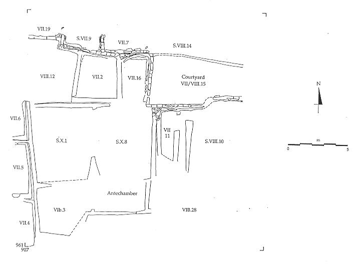
Excavation was therefore conducted over an alignment of three buildings on an east-west axis which Mellaart called Shrine 10 to the east, Shrine 8 in the centre and Shrine 1 to the west (Figure 8). Mellaart's building numbers (defined as Shrines, Houses or Courtyards) continued through different phases but were suffixed by Level numbers as a new phase of building was reached. He began with the latest structural phase as Level I and reached Level XII in a restricted area only. For ease of reference to Mellaart's sequence the current numbering system has maintained the use of Levels to denote structural phases but different building numbers were allocated to each new structure. These numbers had no sequential value and were used only for identification purposes. 'Spaces' were defined within buildings to allow reference to different rooms, but were also used to refer to external areas.
Mellaart's work in Shrines 10, 8 and 1 had stopped at different levels in each structure. Shrine 10 consisted of two rooms, the smaller room to the west he labelled as an antechamber to the main shrine. The antechamber had largely been excavated to Level VII with a small room to the south he called House 28 and ascribed to Level VIB. The larger room however was excavated to Level VIII and partial excavation of features had taken place. Shrines 8 and 1 had both been excavated to Level X but a metre baulk of Level IX stratigraphy had been left in the southeast quadrant of Shrine 8. In both Shrines 1 and 8, Level X features and floors had also undergone various stages of excavation.
Mellaart dug his deep sounding, measuring 5m x 1m, through the Level X floors to the north of Shrine 8. In the 6m sequence he excavated he recorded that there were no earlier buildings below Level X, (although he did record a Level XI) and that immediately below Level XI, a humic deposit overlay a sterile clay layer which he interpreted as a flood event from the river running along the western edge of the site in the neolithic period. The 'flooding' event sealed 12 Aceramic Levels of midden with at least ten floors. He did not succeed in reaching natural deposits and results of this season's work showed that he stopped merely c.20cm above natural marl.
Excavation strategy
The aim was to excavate the area of buildings to natural marl by stepping-in to avoid deep vertical sections. As the season progressed a flexible approach had to be adopted to accommodate the nature of archaeology found and the restraints of minimal wall removal. The slow progress through the micro-detailed and complex stratigraphy of the buildings resulted in abandoning the idea of reaching natural below Shrine 10 but gave the opportunity to excavate at least one complete building. Progress in Buildings 23 and 18 was at a faster rate, removing 1960's backfill which sealed Level X whilst recording wall elevations of the later levels. Locating the trench over Shrine 8 gave the opportunity of re-examining Mellaart's deep sounding and also provided a 'window' to the lower deposits.
Level X, being the last structural phase below Shrines 1 and 8, afforded a faster rate of excavation through the underlying midden deposits and also meant that the area could be joined without divisions created by structural walls. Pre-Level X, the area was called Space 181. An arbitrary trench was stepped-in from the surrounding walls to a maximum 7.4m x 3.2m area, and excavated down to natural marl at a depth of c.999m OD approximately 4m below buildings 18 and 23 where the excavated area measured 5.2mx 1.5 m.
As excavation progressed issues concerning health and safety were constantly addressed. Late walls surrounding the areas of Shrines 1, 8 and 10 had to be excavated to remove the potential for dangerous overhangs but which in turn required the excavation of associated stratigraphy on both sides of the walls. Accordingly peripheral excavation therefore took place to the north and west. Shelter over the excavation area was also necessary both for the team and the archaeology. Destablisation of the walls caused by exposure to fluctuating environments of rain, direct sun and dewy mornings resulted in dramatic cracks that became a safety hazard. The project was also long enough to subject the excavation team to the rigours of summer and winter temperatures. The shelter was therefore needed to maintain a relatively constant environment. As the excavation area got deeper safeguards against section collapse also had to be ensured by constructing a continuous wood plank shoring. Both shelter and shoring projects were major engineering schemes and ensuing hurdles were surmounted with huge success, all credit going to the great design by Lindsay Falck and the help and support from the many team members.
Summary
Elements of structural Levels VI - XII and pre-Level XII, subdivided as phases A to E, deposits of 'midden' and 'dumps' were excavated and recorded within the area of excavation.
Overlying natural marl was a thick band of alluvially disturbed midden dumps, the artefactual content of which was similar to the overlying stratified 'midden', but in appearance it had been reworked through alluvial activity from the ancient river that ran along the western edge of the settlement. There were no backswamp deposits, the absence of which, and the irregular surface treatment of the underlying natural, suggested that quarrying for marl may have taken place. Overlying the alluvially worked 'midden' were similar broad bands of primary deposition dumps with no signs of reworking through water activity. However these were also dissimilar to the distinct lenses and fine layers of the overlying ashy midden, similar to those previously excavated in Space 115. On this basis, and combined with analysis of the artefactual and environmental assemblages, these deposits were interpreted as accumulated off-settlement 'dumps'. Overlying these a change of activity was indicated by accumulation of fine 'midden' lenses. Two phases of channel or water gullies were found through the sequence of 'midden' as well as evidence of lime burning activity and one infant burial. The change of deposit may indicate a change of use of the area associated with a phase of construction in the vicinity, as 'midden' deposits have previously been excavated within the boundaries of standing buildings.
Levels XII and XI were represented by two sections of superimposed walls to the west of Space 181. The associated deposits were of an external nature which placed the building to the west. Associated with the construction of Level XII was a thick and compact layer of building debris forming a raft on the soft 'midden' deposits over which the wall was constructed. The deposits that abutted the 'external' face of the wall were interpreted as 'stable' deposits. The same sequence was present for the overlying Level XI phase, a raft of consolidation material for the construction of the wall which was abutted by 'stable' deposits to the east face. Because there were no further walls of Levels XI and XII represented in Space 181 it is not possible to say whether the area was bounded by buildings on all sides or whether at these early levels the buildings were free standing.
Level XI was sealed by a consolidation layer prior to the construction of Level X, Buildings 18 and 23. Because of the irregularity of the wall faces it was not possible to investigate the bonding of all these walls without undermining the overlying sections, but, the fact that the two buildings shared a party wall with a connecting access hole to the north suggests that they were bonded and therefore constructed at the same time. Both buildings shared the same ground plan, larger rooms to the south with narrow rooms to the north. In Building 18 the narrow room housed a series of 'storage' bins whilst the southern half was occupied by several phases of fire installations which shifted position with each rebuild along the southern wall. The central area was truncated by Mellaart's deep sounding dug in 1963. Building 23 was similar in plan with fire installations to the south, 'clean' floors to the northeast and moulded post bases and/or basins to the northwest. Only two infant burials in baskets were found in Building 23 and one in Building 18.
Level IX was represented by Buildings 17 to the east, 16 in the centre and 22 to the west. Once again Buildings 16 and 22 shared a party wall with an access hole to the north, mirroring the underlying Level X buildings. These buildings had been largely excavated by Mellaart apart from a baulk in the southeast corner of Building 16 where there were a series of fire installations and associated rakeout deposits. Interestingly, the southern section was set back slightly from both the overlying and underlying walls, thereby gaining a little extra space but the western wall was set east of the underlying wall of Level X thus reducing the space on the east-west axis. This could represent a deliberate shift in plan or it was accidental when the later walls were constructed over the infill of the earlier building.
Building 17 consisted of 2 rooms, a larger to the east and a narrow room to the west connected by an access hole to the north. The narrow room appeared to represent a different function in that there were no features and the floors were formed by accumulated debris. The larger room had a series of ovens in the northeast corner which moved to the southwest corner at the latest phase, a platform to the south and a contained hearth area to the southeast. Other basins and bins and later platforms moved around the building at different phases.
Level VIII was represented by Buildings 21 and 7 over Buildings 22 and 16 respectively. Only the walls survived from the previous excavation but at this phase the buildings were constructed as separate entities with abutting central walls and the building fabric also suggested they were constructed independently. Building 6 overlay Building 17 mirroring the earlier building plan with a narrow room to the west housing a hearth to the south and 'storage' bins to the north. Features in the larger room again mirrored those of the earlier building.
Level VII was represented by Space 159 only, constructed over the narrow room of Building 6 and Level VI/B was a small room constructed over the southern end of Space 159.
The archaeology
LEVEL VIB (Figure 9)
Space 160
Level VIB was represented by Space 160 which appeared on plans from the 1960's excavations as House 11. Located to the south of Space 159 of Level VII it formed a small cell-like room which was partially excavated in 1998 when it's relationship with Space 159 was unresolved. Completion of excavation of this space revealed that at Level VI/B it was cut into the southern end of Space 159.
The construction of this cell was represented by a cut [4336] which truncated the walls and southern end of the underlying Space 159. The base of the cut was infilled by [3709] and [3703], possibly acting as a foundation raft for consolidation prior to the construction of the walls.
The cell was formed by bonded walls 405 to the west and 403 to the north. Traces of the eastern wall could only be seen in the southern section of the neighbouring space; having been removed by the 1960's excavation. The southern wall 404, was also represented in section only with an access hole in the south west corner leading to the unexcavated building to the south.
The floors excavated last season as [3620], [3379] and [3343/3344], were not immediately recognised consisting as they did of accumulated lenses formed into floors through use and trample, in contrast to the prepared plaster floors typical of neolithic houses at Çatalhöyük. From these floors the complete profile of a pottery vessel was recovered and the floors were traced through the access hole. Sealing the floors were infill deposits [3191] and [3179] representing the end of the use of the cell.
It is possible that this cell formed what Mellaart identified as 'entrance shafts', which may explain the difference in floor make-up but its function cannot be interpreted with any confidence until the complete building, which lies to the south, is excavated. Interestingly, the construction of Space 160 changed the ground plan of the building, as generally the later buildings reflected the layout of the earlier building. It will be interesting to re-study Mellaart's plans to attempt an interpretation on what dictated this change and whether it was reflected on a wider scale.
LEVEL VII (Figure 9)
Space 159
Space 159 was a small narrow room recorded by Mellaart as the 'antechamber' to Shrine 10 at Level VII (Figure 9). The sequence excavated last season demonstrated that Mellaart had only partially excavated the room and consequently a sequence of infill, floors and two post holes were excavated to the north (Farid 1998). The south proved an enigma until completion of excavation this season when it was revealed that a foundation cut had removed much of the sequence to the south by the construction of Space 160. The south section revealed the continuation of the east and west walls as only two courses with associated floors and a post retrieval pit.
Space 159 was connected to a larger room to the east, Space 180, by an access hole to the north. Together the rooms formed Building 24, Level VII. Space 180 had been excavated by Mellaart (1964, 57), and the walls to the north and east had mostly eroded away. However enough survived to establish relationships and the south and west walls were recorded in elevation. Building 24 was formed by bonded walls 400 to the west, 74/80 to the north, 512 to the east and 511 to the south; the dividing wall was represented by 401 bonded to the north above the access hole. The southern wall lay beyond the excavation area.
From the little that survived it is clear that the function of this room was different to Space 180, as the floors were formed from compacted debris and not multiple applications of plaster. There was also a marked absence of internal 'furnishings' and burials, and the absence of any remnants of storage bins or basins ruled out the function as a storage area. The presence of the two post holes are an anomaly as they would have been superfluous as roof posts in a narrow room such as this. Micromophological samples were taken from the small surviving areas of floor, analysis of which may indicate a specific function.
LEVEL VIII (Figure 10)
Building 6, Spaces 163 and 173,
Building 6 lay directly below Building 24 of Level VII. The only change in building plan was a slight narrowing of the western room, Space 173. The building comprised of bonded walls 479 to the west, 483 to the north, 486 to the east and 485 to the south and party wall 484. Two access holes through wall 484 connected the two rooms, a 'crawlhole' 500 to the north and a small opening 490 to the south, apparently too small for human traffic and therefore possibly serving as a hatch.
Mellaart had largely excavated the larger room, Space 163, of it's features and floors but remnants of archaeology survived around the edges of the room and nine burials were excavated across the space. As the floors had been excavated across the main body of the room the burials and features could not be phased and although the burials were found at sub-floor level they were more than likely cut through floor phases. Overlying the horizon Mellaart had stopped at was a large section of wall collapse which was initially confusing as it could have represented a neolithic collapse but upon excavation it was clearly post-Mellaart collapse and originated from the eastern wall section.
Above the floors of Space 173, infill between Levels VII and VIII was excavated.
To the south of Space 163 the features could roughly be divided into three phases, however their contemporaniety could not be established because of the loss of relationships through truncation. In the southwest corner the basal remnants of platform 428, approximately 2m x 1m, was constructed of material similar to the underlying building infill, but fashioned to form a shallow raised platform. Its northeast corner was clipped by pit 440, the fill of which was primarily clay balls [4291]. Towards the top were numerous fragments but the basal deposit of clay balls were mostly complete. It's proximity to an area where the truncated remains of fire installations and ashy 'rakeout' deposits were found in the southeast corner of the room was probably of significance, as one of the "hottest" interpretations for clay balls is their use as pot boilers.
East of the platform and towards the southeast corner of the room the features and deposits excavated were those associated with oven and hearth activity. Two small post holes were found, [4390] [4334], associated with ash deposits, [4254] [4339], and the remains of a carbonised post [4335] close to, and therefore probably associated with, the truncated remains of a fire installation [4392], too truncated however to establish the form during use. Cutting these deposits was a small cut [4293] containing a cache of obsidian [4280]. Three further small cuts were located towards the centre, [4402] of unknown function, [4182] a small pit with apparent evidence of in situ burning and [4399] containing a mixed group of artefacts [4401], which can best be described as the horde of a small child consisting of bone, shell, stone and obsidian fragments. Alternatively it represented a foundation deposit sealed by a large oven 416.
Oven 416 was first exposed by Mellaart, a substantial construction located towards the centre of the south wall. It was constructed in a cut and measured 1m in length x 0.85m wide and stood to a height of 0.63 m . Ovoid in plan, traces of its domed superstructure were visible in the south wall. This appeared to be the latest feature in the southern area, clipping the very southern corner of the platform 428 and constructed over the fire installations discussed above. Three major phases of use were identified by the presence of fire baked oven floors and associated ash deposits.
Along the northern wall were a series of heavily truncated features of possible wall mouldings, plaster basins and/or storage bins as well as a series of fire installations in the northeast corner. These features could also be split roughly into three phases.
In the northeast corner were two superimposed oven bases, the earlier 437 was rectangular in plan constructed within a cut with an elaborate basal packing of clay ball fragments towards each corner [4298], over which the primary oven base [4277] was fashioned. A second baked oven floor was represented by [4295] and associated fill which was in turn cut by a second oven 433 with apparently only one phase of fire baked base. Immediately to the west was the very basal remnants of what appeared to have been a plaster constructed basin or bin 434. A change in activity area was marked by the 'closure' of these features by the construction of platform 424 over the top. It is likely that this coincided with the construction of oven 416 to the south. Other features located against the north wall included 427, consisting of several applications of plaster and clays which appeared to form a base for some superstructure, possibly a post pad or the base of a wall moulding. In turn this was cut by, and modelled over by, the heavily truncated remains of a possible plastered basin 431. Just in front of this group of features were further heavily truncated plaster remains of shallow basin 432.
Cutting features to the north and south were two post retrieval pits, [4184] located against the north wall and cutting platform 424 and post retrieval pit [4171] towards the south of the eastern wall. It is difficult to interpret these as roof supports as in a building of this size at least four would be expected and they would most certainly be mirrored on the opposite sides. It is possible however that their proximity to the fire installations may indicate a function related to the support of a roof opening instead.
Nine individual burials were excavated in Space 163, three adults and six infants, located right across the room. Infant burial 476 was close enough to platform 428 in the southwest corner for it to have been associated with it but the cut was only found during excavation of the underlying infill deposits. The infant was buried in a crouched position which was badly crushed through overlying deposits.
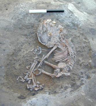
Similarly burial 464 was encountered after platform 428 had been removed but it too was probably cut through the platform (Figure 5). The infant (skeleton [4406]) was in a crouched position with traces of reed matting beneath it indicating that the infant was either wrapped in matting or placed in a basket. Despite a crushed skull it was one of the most intact infant burials found, with bracelets of white, blue/black stone and bone beads around both wrists and teardrop shaped bone beads around the ankles, none of which appeared to have been dislodged and were possibly in their original position. Traces of yellow ochre was also found across the bones. This burial was block-lifted and is currently on display in Konya Archaeological Museum.
Burial 513 was an adult skeleton [4615] located towards the eastern wall, in a crouched position, and was the first with an intact skull. It had traces of ochre [4620] at the base of the grave cut, traces of soot in the rib cage [4621] and the torso was covered by a thick deposit of owl pellets [4619]. The significance of the owl pellets is still under consideration, it was definitely a secondary deposition not in situ droppings over an open grave. Interestingly the grave also contained a high concentration of carbonised cereal grains, a complete weasel skeleton and bones from a small dog. A control of the fill compared to the surrounding deposits was carried out to determine whether these were deliberate items placed in the burial or part of the assemblage from the backfill.
Burial 460 was also an adult located in the centre of the room in what was a relatively large grave cut. The skeleton was found in a semi-crouched position with its head raised higher than the body. A concentration of phytoliths were located near the rib cage and over the right femur but there were no visible signs of weaving or plaiting only appearing to lie in a bundle of parallel lines. Pockets of owl pellets were also recovered from the fill but were unlike those of burial 513. Cutting the fill of burial 460 was the burial of a neonate [4328] in burial 442.
Three infant burials were located in the northeast quadrant, burials 494 and 475 were infants buried in baskets and burial 487 had traces of basket only. The baskets were made of woven reeds or grasses and had separate lids. The lids and body of the baskets were mostly slumped and distorted by the overlying weight of deposits .The skeletons within were in crouched positions and the grave cuts were just big enough to contain the basket.
Burial 492 was the remains of a headless adult, located in the northwest quadrant of the room against the west wall. (Figure 6). The skeleton [4593] lay in an unusual position on its back with knees drawn up but splayed and ankles together. Over the torso was a layer of phytoliths [4617], again in parallel lines with no sign of a weave and over that the carbonised remains of a large piece of wood [4460]. The size of the burial cut indicated that the body had been placed headless and not removed after decomposition had taken place. The significance, if any, of the position of the skeleton and the wood is still under consideration and the popular interpretation for the headlessness is the ritual of the physical transportation of the head of an ancestor, possibly the head of the family unit, through to the next 'home'. Because of the limited stratigraphical relationship of floors and features it was not possible to determine the stratigraphic order of the burials across the room, and therefore it was not possible to determine whether any significance was attached to the burial order of this one.
Space 173 connected Space 163 by an access hole 500 to the north. The deposits in Space 163 were too disturbed and truncated to follow through to the smaller room so relative phasing of the two rooms could not be established. It was evident that the deposits in Space 173 had been heavily truncated prior to infilling at the end of its life use. However based on the surviving deposits the room appeared to have been divided into four discreet activity areas, and the differential depth survival suggested that the different activity areas were possibly stepped down from north to south. Immediately in front of the access hole were a series of heavily truncated plaster rimmed basins or storage bins, the location of which would have impeded free passage from one room to the other. Immediately to the south of the bins the deposits had been truncated directly down onto the infill of the underlying building, while further south again was an expanse of plastered floors and finally, a shallow ridge across the width of the room defined a hearth area with associated ash rakeout deposits.
Three main phases of construction were represented by bins/basins to the north, 488 located immediately in front of access 500, 518 to the west of it and 520 to the south of 488. In the final phase all three would have been contemporarily in use but having been remodelled, repaired and replastered throughout their life history. No primary fills or residues were recovered from the features as they had been scoured clean at the end of their use. Surrounding the 'storage' features were discontinuous patches of floor and packing which linked to various episodes of replastering or remodelling events but any relationship linking through to the 'clean' floors to the south had been truncated.
A shallow step separated the 'clean' floors from and ash deposits and activities associated with the hearth to the south. The step was formed by material similar to the underlying room infill and in appearance was not dissimilar to the construction and function of platforms in other buildings.
Against the southern section were hearths 523 and 502 which represented at least three main phases of baked hearth floors with shallow rimmed surrounds which had undergone several repairs and additions through their lifespan. Associated ash and rakeout deposits surrounded the hearths compacted into discontinuous surfaces through wear. Cutting the 'floors' were shallow pits and scoops, [4798], [4889] and [4914] of unknown function. A small pit cut [4942] was located in front of the hearth within which were a concentration of clay balls [4941], again as in Space 163, and its proximity to the fire installation, it must represent some associated activity. A single infant burial in a basket, 537, was also found close to the hearth and against the east wall.
To the south of the east wall was a small opening, 490, connecting the southern areas of the two rooms. Barely large enough for a person to slide through, its function may have served as a type of hatch. In the south corner to the west was niche 480 built into wall 479, and on the eastern face of wall 479 was feature 481, moulded plaster in the form of an engaged pilaster with a cavity suggesting the inner core may have disintegrated or been removed.
It is difficult to distinguish separate functions for the two rooms that made up Building 6 as so many of the features are replicated, however it is just as difficult to interpret the two as independent rooms. There was, however, a difference in the fire installations in that those in Space 163 were ovens with domed superstructures whereas in Space 173 the fire installation was clearly a type of hearth. That different types of cooking or heating activities were differentiated is apparent by the different locations of ovens and hearths in most buildings, but in Building 6 this was taken to an extreme by placing it in another room. Alternatively, perhaps the use of Space 173 was not so defined and it may have served as a multi-functional room.
LEVEL IX (Figure 11)
Building 2, Space 117
Space 117 of Building 2 was largely excavated in 1998 and strictly speaking lay beyond the area for excavation for this season, but as it was so close to completion it was appropriate to quickly finish the sequence.
As it was left at the end of 1998 (Figure 14), two platforms against the eastern wall remained constant through all the phases within the building, platform 292 also lay in the northwest corner, platform 291 lay in the southwest corner and located against the southern wall in the centre was oven 269 with abutting hearth 293.
Already excavated (Farid 1998) was oven 290 set within a niche in the western wall which post-dated platform 292. This in turn pre-dated oven 268 set in the southwest corner which was constructed over platform 291. A demarcation in the form of a shallow ridge defined and contained the ash rakeout deposits associated with the fire installations in the southern half of the room whilst the northern half consisted of successive plaster floors, the so called 'clean' area.
Feature 291 in the southwest corner, interpreted as a platform last year, was in fact a deliberately constructed plastered base for the raising of the overlying oven 268. In turn it had been constructed over earlier oven 450, of which only partial remains of the baked floor survived within its construction cut [3996]. Related to the compacted deposits associated with 450 was a shallow depression filled by a group of tightly packed, unburnt and unscorched stones. Below that again was oven 451 within construction cut [4110] which was filled by a levelling deposit [4109] over which oven floor [4103] was laid.
Associated with these various phases of ovens were discontinuous deposits of ashy rakeout compacted into surfaces through use. The very basal remains of yet an earlier oven 409 was sealed by oven and related ash deposits 451, it survived only as a heavily truncated oven floor [4118] within cut [4119],and heat affected surrounding deposits. The earliest fire installation in the southwest corner was represented by 411, a shallow heat affected depression. The associated 'floor' deposits abutted platform 292 in the northwest corner and a shallow 'step' feature [4159], comprising brick fragments, extended from the southeast corner of platform 292 towards the southeast of the room. This possibly functioned as a barrier between the oven activity and the 'clean' area to the north. The initial ash deposits sealed a series of shallow depressions two of which contained obsidian caches, [4134] and [4138], and one, a group of clay balls [4135]. The depressions were unconvincing as cuts and may have represented the negative impressions of containers thrown into the upper fill of the building below.
Platform 292 in the northwest corner was one of the earliest features of the room; constructed from re-used burnt brick fragments [4162] it formed a shallow ledge to the east and south, abutting walls to the north and west. It had a thick but single application of plaster [4161] on the east and south sides and a make-up or levelling layer [4164] within it. There were remnants of floor [4165] below the platform which indicated it was not a primary feature. The floors overlay makeup and levelling deposits over the infill of the building below.
To the east of the room oven 269 was constructed within cut [4113]. The horseshoe shaped oven superstructure was associated with successive ashy deposits in the vicinity which linked stratigraphically to the ashy deposits originating from the ovens in the southwest corner thus establishing that oven 269 post-dated fire installation 411. Related compacted ash floors abutted platforms 288 in the northeast corner and 287 in southeast corner and the floors to the northeast linked to floors over the northern half of the room.
The eastern platforms were modelled over the top of a wall from the underlying Level X building, taking advantage of the already raised area, although further definition was given to platform 288 by the use of re-used mudbick fragments laid on top.
A post hole cut and an area of scorching was found at the interface of the make-up and levelling deposits for Space 117 and the infill of the underlying building, indicating some contemporary activity had taken place.
A small painting was found on the east wall of Space 117, north of the access hole linking the two rooms of the building and above platform 288 (Figure 7). The painting was red ochre on white plaster and formed a pattern of concentric lozenge shapes creating almost a beehive type pattern. Overlying the red paint were traces of black painted lines but which were too discontinuous to form an image. Clearly this corner had a history of 'decoration' on the wall. The significance, in so far as there is any, is that in Mellaart's terms a fairly insignificant building of this type could still yield some form of 'artwork'. The painting is currently on display in the Archaeological Museum in Konya.
Building 17, Spaces 170 and 182,
Building 17 lay directly below Building 6, and was the same in plan and roughly in size too. It consisted of a large room, Space 170 to the east (Figure 15), and a narrow room, Space 182 to the west, connected by an access hole to the north through the party wall. The infill between the buildings was approximately a metre in depth. The initial infill comprised fragmented bricks and mortar through which the roof posts had been retrieved. The whole building was then infilled with a finely graded homogenous deposit.
The bonded walls forming Building 17 were 483 to the north, 486 to the east, 485 to the south and 479 to the east, while the party wall dividing the two rooms was wall 484. The south wall and the southern half of the east wall were only exposed in small slots as they were set slightly back from the later overlying walls. Post holes, identified as post retrieval pits, were located against the east and west walls, two on each side approximately a metre in from the corners and aligned to the opposite post holes, with a fifth located against the centre of the southern wall. These posts provided supports for a roof and were not integral to the structural support of the walls. Although the removal of the posts left scars in the wall plaster, the post cuts were not actually cut against the wall faces suggesting that they were practically freestanding. The southern post hole presented an anomaly in that it was not mirrored by a post hole on the opposite wall, however cut [4646], on roughly the same alignment, but located away from the north wall, may have been the pairing post hole. Alternatively the southern post hole may have been to support a ladder post, giving access to a roof hole located over the fire installations.
The building was not completed this season but a uniform phase was reached in Space 170, the earliest of three phases, and an understanding of Space 182. The floor deposits in the two rooms could not however be stratigraphically linked because of a shallow step across the threshold of the access hole against which deposits abutted on either side.
The earliest exposed but not excavated phase in Space 170 revealed a series of features along the north and south walls with a large expanse of floor [5365] in the central area. The floor comprised successive applications of floor plaster and packing visible in the sides of excavated intrusion cuts. Floors [5365] represented the 'clean' area of the room and clear demarcation from other activity areas and features was created by edges of platforms and raised ridges. To the west was a shallow rise in floor (584) which may have marked the area of an earlier circular feature. Other signs of features cutting this surface, detected but left uninvestigated through lack of time, included 587 to the south and 582 to the northeast, possible grave cuts.
In the southeast corner forming an arc was a low ridge which formed a boundary in the south east corner which contained circular hearth 545 and associated ash and rakeout deposits [5046] forming the 'dirty' area. To the west the ridge joined the raised edge of platform 558 which extended to the western corner of the room, where it merged with a series of three plaster basin type features located in the extreme southwest corner. The platform was roughly rectangular and stood about 20cm above the floor. The floor plaster was contiguous with that applied over the platform as [5375].
Aligned against the western wall, the plaster features consisted of two basins, 586 in the southwest corner and 585 to the north, and a central feature 574. The basins were shallow rimmed whilst 574 appeared to represent a work bench constructed as a small shallow platform with a flat surface. However an animal hole revealed a core of carbonised wood suggesting that the feature may have been a post pad.
To the north, the northeast corner was occupied by the truncated remains of oven 579 with remnants indicative of a domed superstructure. The remains of associated fire installation 580 to the south may have been a hearth or horseshoe shaped fire structure. The associated ashy deposits were contained to the 'dirty' northeast corner by shallow ridge 581, while abutting the centre of the north wall was a double plaster basin 577/578. The floor in the northwest corner was associated with the access hole to Space 182 and as such was worn and irregular. The 'dirty' floors to the east appeared to merge in with the 'worn' area. A delineation may have existed between the access passage and the 'clean' floors in the main body of the room to the south, in the form of a plaster partition as suggested by a wedge of plaster lipping out from the wall face immediately to the south side of the access hole. This protruded as far as the post retrieval hole and lay on the same alignment as demarcation ridge 581 which contained the oven activities to the northeast corner.
A packing, levelling or foundation layer, [5364], was laid over floors [5365] which defined the next phase of the room over which lay the discontinuous floor [5362]. Shallow ridge [5363], formed a partition between the worn area associated with the access hole in the northwest corner and the main body of the room, and it was also aligned with ridge 581 to the east which continued through to this next phase. A thick white make up/packing layer of a plastery composition, [5356], was deposited across the main body of the room over, which a small repair, [5361], was made to the partition ridge before floors [5344/5339] were laid down.
Cutting the floors against the east wall were two infant burials, 564 to the north and 576 to the south, both of which contained single crouched interments in baskets.
The 'dirty' area in the southeast corner continued in use through to this phase, the ridge having been raised by the same material as the make-up. Within the area were ashy rakeout deposits the earliest of which, [5043], produced the head and torso of a physically ambiguous figurine and the head of another. These multiple deposits were associated with a circular rimmed hearth, 541, which was a rebuild of the earlier 545. The platform to the west also continued through to this phase. It was cut by an adult burial 563, which was sealed by plaster 'floor' [5161]. The platform was reduced in length as a further plaster basin, 569, and a small plastered work bench, 575, were constructed to the east of the three plaster features from the earlier phase. Floor [5182] was traced around these features in the southwest corner across the western half of the room and linked to the northwest corner. Two ovens were constructed over 579 and 580 in the northeast corner, an earlier one represented by 571 and the later 555. Both appeared to have been free standing as neither abutted the walls and both had signs of domed superstructures. Evidence of several phases of firings, remodelling and repair were recorded, and, associated with a phase of oven 555, was shallow pit or depression [5156] filled with complete and fragmented clay balls, located at the 'head' of the oven structure.
A major change in the spatial use of the room took place in the final phase, it consisted of successive plaster floors [5020] in the main body of the room forming a 'clean' area. The basins and 'work benches' in the southwest corner were infilled and deposit [5171] sealed them creating a raised platform along the length of the west wall. Oven 546 was constructed over this new platform in the southwest corner with a domed superstructure and a shelf-like feature on its dome (similar to oven 268 in Building 2).The associated floors on the platform were represented by [5072] and [5073].
The ovens in the northeast corner were sealed by the construction of plastered platform 553, apparently constructed for the sole purpose of raising the area in this corner as there was no evidence of the platform being used. Rather a series of plaster bins, 547, were constructed over the top incorporating several phases and rebuilds.
The only features that continued in use to this final phase were platform 558, against the centre of the south wall, and the 'dirty' hearth area in the southeast corner with a later hearth construction 538.
The wall plaster, where exposed, consisted of multiple applications resulting in a thickness in excess of 1cm in places. The surfaces were irregular producing ridged effects to the extent that in the northeast and southwest areas it appeared as if a deliberate 'dado rail' effect had been fashioned but which was not continuos all around the room ( a study of these irregularities in wall plaster was made and appeared to be the result of a fault in the initial plaster application, either as a small ripple or a piece of grit, which then became consistently exaggerated through successive plaster applications to finally appear as a deliberate 'feature'). Areas of red paint were noted on the southeast facing wall and in the northwest corner two small ledge or shelf features, fashioned from a dense plaster matrix, protruded from the corner beside the access hole 583 which connected through to Space 182.
Access hole 583 was a rectangular opening circa 0.5m in height with a step in the threshold forming a barrier between the deposits of one room from the other.
The floors in Space 182 appeared to consist of accumulated occupation deposits, trampled through wear, to form discontinuous floor horizons [5245], [5246], [5243] and [5240]over which numerous fragments of debris were recovered. These consisted of obsidian and flint artefacts, bone, pottery fragments, traces of basketry and general domestic waste debris. Three horizons of similar deposits were identified, which probably relate to the three phases excavated in Space 170. A small portion of an unidentified feature, 573,was found in the southeast corner but which extended into the arbitrary section to the south of this space. The wall faces were plastered in a 'mud' rendering and there were areas of thickened walls which suggested that at an earlier phase, rebuilds were added to the north and east walls to act as supports for possibly weakened walls.
At the end of the life of the building the access hole was blocked with fragmented bricks and solid material prior to dismantlement of the roof, resulting in an initial infill of fragmented brick and mortar. The archaeological record then shows that the upright roof posts from Space 170 were removed before the deposition of the finer graded homogenous building infill. The infill of Space 182, however, differed in that differential tip lines falling from west to east were traced, consisting of similar finely graded homogenous material.
Of interest was post retrieval pit [4604], in the northwest corner of Space 170, which had a secondary cut, [5175], interpreted as a hole resulting from a greater force required to drag or dig the post out. Within the backfill of [4604] was a redeposited human skull, [5022]. The question of whether this could be the head of the last individual buried in the underlying building ritually carried through to the next generation was much debated.
Clearly the two rooms of Building 17 served different functions, Space 182 showing great similarities to the 'dirty' areas in Space 170. A clearer interpretation of the different activities performed in the two areas will be available once the results of the micro analysis are completed.
Building 16, Space 164 (Figure 16)
Building 16 / Space 164 is the same as Mellaarts shrine IX.8. Although its external walls survived [447 to 449] most of the building was excavated in 1963. An area of in-situ archaeology approximately 2.4m north-south by 1.2m west-east remained in the south-east corner which was excavated. Additionally traces of floors remained against the northern and eastern walls and as the southern wall of the building lay to the south of the area of excavation a complete section through the deposits survived. Building 16 shares a single party wall, 447, with building 22 to the west so it is not clear if these are actually separate buildings. Mellaart records them as separate buildings [shrines IX.1 and IX.8], however, given his failure to systematically remove plaster from the walls this is inconclusive. No crawl-hole connecting the two buildings was found but as part of wall 447 had collapsed due to proximity with the 1963 deep sounding this is also inconclusive and the relationship between the two buildings remains unclear although, the pottery from the 1960's excavations suggests that the two buildings may have been linked (Last 1996, 166).
The 1960s Excavations.
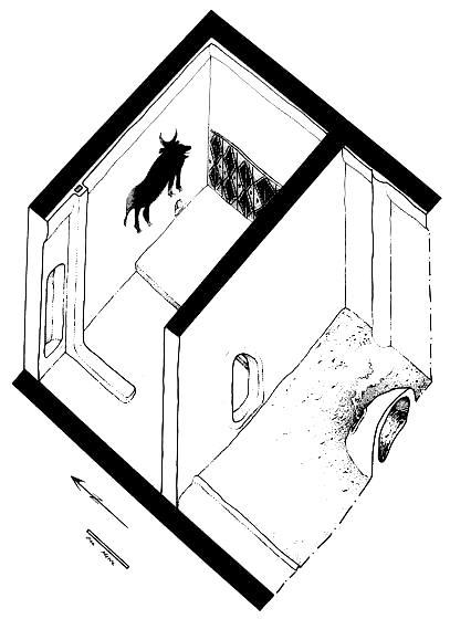
Shrine IX.8 was excavated in 1963 and was described and illustrated in some detail (Mellaart 1964, 70 plus fig 24 and plate XIVb; 1967, 105 plus fig 18, plate 11, tables 13 and 16) although unfortunately no plan of the building was published. Additionally a number of unpublished photographs taken by Ian Todd survive (unpublished slides 62.19, 63.24 and 63.25). Mellaarts description is as follows:
The shrine next door, IX, 8, however, showed an unusual plan of antechamber with a great oven and a small, but richly decorated, sanctuary (Pl. XIVb). In its final phase, the north wall bore the cut-out silhouettes of two animal heads; a horned animal (probably a bull) on the left and a feline (probably leopard) head on the right (Fig. 24). These were cut through deep layers of white plaster, but the second horn of the bull was destroyed when the wall was cut down to fill in the building (at the end of Level IX). Belonging to an earlier phase of decoration was a huge black bull with carefully drawn hooves (Pl. XIVb), shown marching to the right. Below it was a niche and a rectangular structure drawn in red. The bull was decapitated with the destruction of the north wall. On the panel of the east wall in front of the bull was found a polychrome geometric pattern in red, black and white, imitating a kilim. Once again the presence of a bull on the north wall of shrines in this position should be noted, for this is the third in succession (Shrines VI, 8, VII 8, and IX, 8).
(ibid, 70).
This description focuses on the art work which caused Mellaart to describe this building as a shrine, no traces of which remained when the building was revealed in the 1990s, but does provide some information on the layout of the structure, the figures and plates also provide a range of incidental detail.
1999 Excavations.
Building 16 was a rectangular structure c.5.7m+ north-south by c.4.5m west-east. The full north-south extent is unknown as the southern wall lies further south than the phase VIII wall 445 above and was not revealed but it is probably not far south of the limit of excavation.
The northern wall 448 survived to a height of c.1.2m and retained some traces of wall plaster [4370] and [4379]. Also surviving was the very edge of a sequence of clean plaster floors [4371] lying at between 1004.5 and 1004.6m OD. Near the eastern end of wall F.448 there were bulges and a scar in wall plaster [4370] indicating the presence of a plastered post 461 which is confirmed by the reconstruction drawing and photographs from the 1960's. No traces of the cut-out silhouettes of animal heads and wall painting mentioned by Mellaart survived.
The western wall 447 survived to a height of c.1.1m and retained some traces of wall plaster [4357] but no evidence for floors survived. At the northern end of the wall there was an irregular gap 462, c.0.6m wide which corresponds to the location of a niche shown in the reconstruction drawing and photographs from the 1960's. Approximately midway along wall F.447 there was a 0.28m vertical break in the wall plaster [4657] which corresponds to a pattern in the brick and mortar indicating the existence of a bonded in east-west internal wall 452. This is aligned with internal wall 436 which is bonded to the eastern wall 449 [see below] and tallies with the evidence of the 1960's description and photographs.
The eastern wall 449 survives to a height of c.1.1m and retains some areas of wall plaster [4380] and traces of clean plaster floors on the northern part of the wall [4381] and [4382] at 1004.45 and 1004.6m OD respectively. No traces of the geometric wall painting referred to by Mellaart survived. Approximately midway along the wall there was a rectangular niche 465 situated c.0.55m above floor height. This niche which was c.0.25m+ high, 0.65m wide and 0.35m deep was originally plastered [4385] and at some stage in the history of the building was blocked with bricks and mortar [4384]. Other features associated with wall 447 will be discussed subsequently as they can be related to the main sequence of deposits.
The area of in-situ archaeology in the south-east corner, although only approximately 2.4m north-south by 1.2m west-east, preserved a complete sequence through building 16 and could additionally be linked to features revealed in the southern section. The building 16 deposits were sealed by traces of a general infilling layer [4300] which marked the transition from level IX to level VIII. The latest feature in the building was a post retrieval pit [4303] which was dug to remove the plastered post 463 which could also be identified by a bulge in wall plaster [4380].
The main element of the area excavated was a sequence of four fire installations; 435, 438, 439 and 457. The earliest fire installation was oven 438, this is probably a rectangular/sub-oval north-south aligned domed oven with at least four phases indicated by rubefied floors [4353], [4349], [4314] and [4313]. The final phase [4312] which appears to be a combination of the ashy reside from he final use of the oven plus demolished oven superstructure has two apparently in-situ clay balls [4312] X.1 and X.2 suggesting that these objects were used in the oven. Contemporary with the construction of 438 a raised area was created in the south-west corner between the oven and wall 449, its function is unclear but it could have performed a storage or other function related to the oven. In location and form it is similar to 496 in the preceding building 18. 438 was replaced by oven 439 lying slightly to the west which was not excavated and is only visible in section. It only appears to have one base and is delimited by a pair of raised plaster edges, it also had an apparently in-situ clay ball [4315] X.1. All in all it seems to be rather atypical but it is difficult to be sure as it was not excavated. The sequence after this is less clear as there is no direct stratigraphic relationship between F.I.'s 435 and 457, however, F.I. 457 is probably later than F.I. 439. F.I. 435 lies directly over 438. It seems to be very similar to 438 in size and form and has three rubefied bases [4310], [4308] and [4306]. F.I.457 which lies above F.439 at its western was a well constructed but relatively small oven which had two rubefied bases and was only revealed in section. Lying to the north of the F.I.s were a series of dirty floors/trample layers/oven rake-outs [4344], [4342], [4318], [4316] and [4304] at between 1004.5 and 1004.15m OD which could be directly associated with individual F.I.s. There were also two clean plaster floors [4343] and [4319], [4319] was particularly interesting as it had a brow tine of an adult red deer antler [X.2] and a clay ball [X.1] lying on it. There were two obsidian clusters [4305] and [4317] which were associated [4304] and [4316] respectively. There are a total of ten oven bases from this building which is probably an accurate total for the building as a whole. As oven bases appear to have been replaced when they became too badly damaged and cracked to be of further use then the number of oven bases in buildings may be an indicator of their relative life spans.
F.I. Associated deposits |
|
438 rake-outs [4318], [4342] and [4344], clean floors [4319] and [4343]. |
|
439 rake-out [4316], obsidian cluster [4316]. |
|
435 rake-out [4304], obsidian cluster [4305]. |
|
457 no definitely associated rake-out but possibly also related to [4304]. |
To the west of the F.I.'s a number of floors [4373] and [4375] were revealed at between 1004.15 and 1004.0m OD which became progressively cleaner as they get further away from the F.I.'s. There were also a pair of ridges in the floors [4374] and [4704] indicating some form of north-south spatial division which moved eastwards during the history of the building.
The earliest feature constructed was an internal east-west wall 436 0.54m wide composed of bricks [4346] and mortar [4347] with four courses surviving which acted as the northern boundary for the area of ovens and dirty deposits. This wall was aligned with 452 on the western wall 447 and presumably completely divided the smaller southern part [2.4m+ north-south by c.4.5m west-east] of the building from the larger northern part [c.3.0m north-south by c.4.5m west-east] which a 1960's photograph shows were connected by a large crawlhole. This corresponds to Mellaart's description of an 'antechamber with a great oven and a small, but richly decorated, sanctuary'. The area which survived to be excavated appears to be a 'dirty/domestic' area and the few traces which survived in the northern area appeared to represent a 'clean/ritual?' area. Although only a small amount of building 16 survived it is of interest because it was a structure identified as a shrine by Mellaart in the 1960's. By the 1990's when the elements which Mellaart has based his shrine identification upon, the cut-out silhouettes of two animal heads and the wall painting of a huge black bull, had gone the deposits that remained appeared no different from other buildings.
The level IX building 16 deposits are separated from the preceding level X building 18 deposits by c.0.7m of relatively sterile infilling deposits (4355), these contained a single large obsidian preform [4355] X.1 close to the base of the unit which may represent some form of special deliberate deposit marking the transition between buildings.
LEVEL X (Figure 12)
Building 9, Spaces 166 and 167
The plan of Building 9, Level X was only partially exposed and not excavated. It lay directly below Building 2 of Level IX maintaining the same spatial area of the overlying building, but with the dividing party wall located slightly west of the later building plan. Currently it would appear that the building consisted of two rooms, larger Space 166 to the west and smaller Space 167 to the east. However as the overlying room Space 116 Level IX, has yet to be excavated it is uncertain as to where the limits of the underlying building to the east are.
Building 18, Spaces 171 and 172 (Figure 17)
Building 18 / Spaces 171 and 172 is the same as Mellaarts room X.8. Although it had suffered some damage in 1963 due to Mellaarts sounding and related activities substantial deposits survived to both the north and the south of the deep sounding. As the two sides of the sounding represent different spaces these will be discussed separately, space 171 lies to the south of the sounding and space 172 to the north. Building 18 as a whole was c.5.6m north-south by c.4.6 to 4.0m west-east, within this space 171 was c.4.6m west-east and it would have originally been c.4.0m north-south, only a maximum of c.2.4m of in situ-archaeology survives. Space 172 was c.4.0m west-east by c.1.0m north-south.
Building 18 is defined by walls 467 and 507 to the west, wall 468 to the north, wall 469 to the east and wall 470 to the south. The two spaces 171 and 172 were divided by a substantial internal east-west wall F.471 c.0.35m wide of which only a small part at the eastern end survived.
Building 18 shares a single party wall, 467/507, with building 23 to the west so it is not clear if these are actually separate buildings. Mellaart records them as separate buildings [shrine X.1 and room X.8], however, given his failure to systematically remove plaster from the walls this is inconclusive. No crawl-hole connecting the two buildings was found but as the area between walls 467 and 507 had collapsed due to proximity with the 1963 deep sounding this is also inconclusive and the relationship between the two buildings remains unclear. Some incidental details, on wall 482 in building 23 and on collapsed wall sections discovered in the deep sounding suggest that buildings 18 and 23 may well have been a single building.
The 1960s Excavations.
Room X.8 was excavated in 1963 and was briefly described (Mellaart 1964, 70) although unfortunately no plan of the building was published. Mellaarts account is slightly confusing as he numbers the building X.1 but from its context, directly following a description of shrine IX.8, it is clear that he is actually discussing room X.1. Mellaarts description is as follows:
The building immediately underneath, X, 1, [actually X.8] had no features which definitely marked it as a shrine. The long narrow room along the north side was filled with strongly built, but empty grain-bins. A few worn smears of paint on the north and east walls of the main room suggested the possibility of geometric kilim paintings of familiar type, but they were too fragmentary to restore the pattern.
(ibid, 70).
1999 Excavations.
Space171.
The initial event in the creation of the space was the deposition of a foundation layer of thick, homogenous and relatively sterile material [4657] and [4708]. The development of the space is determined mainly from a group of six fire installations occupying locations in the south-central area and south-west corner of the space. 1960's truncations mean that it is impossible to link all the archaeological deposits stratigraphically but it appears that only one fire installation was ever in use at a time and a relative sequence of fire installations can be constructed which allows the space to be phased:
|
Phase |
F.I. |
Location |
Bases |
Associated Feature/Layers |
|
1 |
501 |
south-west corner |
[4589], [4590] |
[4587] |
|
2 |
495 |
south central |
[4562] |
496 |
|
3 |
499 |
south-west corner |
none survive |
496, [4557], [4559], [4560], [4578] |
|
4 |
472 |
south-west corner |
[4570] |
493, 496, 504, 467, [4548] |
|
5 |
477 |
south central |
[4543], [4544] |
[4539], [4540], [4541] |
|
6 |
473 |
south central |
none left |
[4530], [4531], [4532], [4533], [4534] |
The earliest F.I. 501 was a substantial north-south aligned rectangular domed oven which was plastered on its outer eastern face [4588] and had two bases [4589] and [4590]. It is associated with two badly truncated areas of dirty floors/trample layers/oven rake-outs [4587] and [4588]. Only a very small area of the base [4562] of the second F.I. 495 remained and it appears that most of the deposits associated with this phase had been removed. At the same time 496 an enigmatic square structure in the south-east corner, which may have been a basin, with an opening on its eastern side was constructed. The next F.I. 499 was a substantial north-south aligned rectangular domed oven for which no bases survive. 496 continued in use and an organic residue [4564] was deposited at the structures opening. An area of floor [4560] was laid over the earlier oven F.I. 495 and an area of dirty floors/trample layers/oven rake-outs [4557] and [4578] accumulated to the east and north of F.I. 499. A shallow scoop [4559] in the south-east of the space may be an obsidian recovery cut. F.I. 472 was a substantial north-south aligned rectangular domed oven with base [4570] which was cut into walls 467 and 470. 496 was demolished [4563] but left a raised area in the south-east corner of space 172 which may have functioned as a storage area or be related to a re-positioning of a ladder against the south wall. An area of dirty floors/trample layers/oven rake-outs [4548] accumulated to the east of F.I. 472. The upper part of the eastern wall 467 was modified [4660] and a plastered post 504 was added to the north of the oven, the post appears to be aligned with a bulge in the plaster of the eastern wall 469 and the two wall features may indicate some form of spatial patterning as they approximately correspond with a transition between clean and dirty floors. A crouched newborn burial 493/[4555] was placed in a shallow cut [4556] in the south-east part of the space. F.I. 477 appears to have been a substantial north-south aligned oven with two bases [4543] and [4544]. An area of dirty floors/trample layers/oven rake-outs [4540] and [4539] accumulated to the east of F.I. 477. To the north of this there was an area of clean plaster floors [4541] at a slightly higher level. F.I. 473 was a substantial north-south aligned rectangular domed oven although no bases survive. The area to the east of F.I 473 was covered by dirty floors/trample layers/oven rake-outs [4533], [4530] and cluster [4531]. To the north of this there was a set of clean plaster floors [4534] with a dividing plastered step [4532] which meant that the clean area was c.0.1m higher than the dirty area. It appears that when building 18 was abandoned this area was simply left and not tidied up as a scatter of objects were left in-situ [4530] X.1 - X.22. The location of these objects and the placement of a number of features such as burial F.493 and scoop [4559] in the south-east corner of space 171 suggest the presence of a ladder against the southern wall. A number of bead pre-forms found in dirty floors/trample layers/oven rake-outs of various phases of space 171 suggest that bone working was an important activity in building 18 [see Russell this volume].
The movement of the F.I.'s between two locations in the southern part of space 171 parallels the pattern found in Building 2, there does not appear to be any discernible logic to the way the F.I.'s move between locations within a space. Although some of the F.I. bases have been entirely removed it appears that building 18 had at least eight F.I. bases in comparison to ten in building 16 above. One discernible trend is that through time the F.I.s appear to shift further southwards, in some instances this meant that they were actually cut into the southern wall 470. This meant that they occupied less space within the building, could this be indicative of increasing pressure on space through the lifespan of the structure?
Space 172.
The initial event in the creation of the space was the deposition of a thick foundation layer of homogenous and relatively sterile material [4689]. Within this layer there were a number of large objects including articulated bone [4689] X.3, a group of bone and antler [4689] X.4 and a large obsidian pre-form [4689] X.1. These may all have been special deliberate deposits and have parallels, for example the obsidian is similar to [4355] X.1 under building 16 and [4205] X.1 beneath building 2 and the group of antler and bone parallels cluster [4717] in space 181.
The development of space 172 is determined mainly from a group of three small bins at the western end of the space. The earliest bin was 514 [4687] in the south-west corner at the junction of walls 471 and 507. It was a relatively low and squat square structure with thick walls and internal dimensions of 0.32 by 0.28m. The height of the bin was difficult to estimate but in common with the later bins at this end of space 172 it appears to have been c.0.2 to 0.25m high. The next bin to be constructed was 515 [4681] and [4683] immediately to the north of bin 514. Again this was a low and square squat structure, although with thinner walls, with internal dimensions of 0.36 by 0.26m and internal and external plaster linings [4682] and [4679]. Contemporary with this a bin 466 [4685] was constructed at the eastern end of the space. This was a much larger structure filling the entire eastern end of the space, it had much thinner and more graceful walls up to 0.7m high and with internal dimensions of 1.0 by 0.52m. After this another bin 516 [4677] was added in the north-west corner which meant that the entire western end of space 172 was filled with bins. This structure was very similar to the previous bins 514 and 515 with internal dimensions of 0.38 by 0.32m. At the same stage a plastered post 517 was added against the northern wall 517. There are therefore three main occupation phases of space 172;
|
Phase |
Bins Added |
Bins still in Use |
Other Features |
|
1 |
514 |
||
|
2 |
515, 466 |
514 |
|
|
3 |
516 |
514, 515, 466 |
517 |
The floors in space 172 [4684] and [4686] were very badly preserved but indicate that they were generally of plaster and kept clean, although there was a mat impression [4686] X.1 preserved within the sequence. Space 172 demonstrates a continuity of function, i.e. storage, throughout the history of the building 18 and a pattern of incremental increase in the provision of storage space.
When building 18 was abandoned a number of events occurred in space 182. The upper part of bin 466 was removed but most of the bin was carefully backfilled, [4664], preserving the thin wall. The bin appears to have been quite carefully cleaned prior to the backfilling although a small amount of distinctive organic residue [4688] was left adhering to walls 468 and 469. The internal post from 517 was removed leaving only the rear and base of the structure. In the centre of the area a plaster rich layer [4668] probably represents demolition material and contained an obsidian point [4668] X.1 which may have been deliberately placed. The upper parts of bins.514, 515 and 516 were removed, a thin band of distinctive material with frequent red ochre flecks was placed in the base of 515 and 516, [4671] and [4673] respectively. A flint awl [4671] X.1 was placed in the red ochre deposit in bin 515 [see Carter this volume]. An antler sickle handle lacking its blades [4677] X.1 [see Russell this volume] was left imbedded in the structure of bin 516. After this the bins were carefully backfilled with material [4669], [4670] and [4672] which was similar to the material used to backfill 466. The abandonment of space 172 with the presence of ochre, flint, antler and possibly obsidian objects associated with the bins at the western end suggests some form of complex abandonment ritual.
Conclusions.
The 1963 excavations mean that a substantial area of building 18 had been removed and that the two areas which survived could not be linked stratigraphically. Space 171 showed evidence of six fire installations, which probably indicate separate phases in the history of the building, and associated 'dirty/domestic' deposits. Space 172 contained four storage bins belonging to three phases and indicating a spatially separate storage area with evidence for a deliberate abandonment ritual which contrasts with space 171 where objects appear simply to have been left in-situ. Unfortunately it is impossible to determine how the six phases of space 171 and the three phases of space 172 relate to each other. The trend of increased storage capacity in space 172 and possible increased pressure on space in space 171, as evidenced by the repositioning of the F.I.s, may be linked. Do they indicate an increased population living within the building? The area in between the two excavated areas which had been removed in 1963 is recorded as having traces of wall painting and was probably a 'clean' area with platforms and other features.
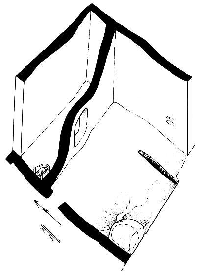
Building 23, Spaces 178 and 179
Building 23 represented the Level X building that Mellaart had partially excavated as 'Shrine 1'. It comprised two rooms, Space 178 (see Frontispiece), the larger to the south, and Space 179, a narrow east-west aligned room to the north. Space 179 had not been fully excavated by Mellaart, and, apart from defining the walls of the space by excavating some of the infill [4477], it was not further investigated. It can be conjectured as having had the same function as Space 172, a 'storage' area in Building 18, as the two buildings were mirror in plan.
As with the overlying Level IX buildings, the wall between the Level X Buildings 23 and 18 was a party wall with a connecting access hole to the north. By definition, these should be considered as one building, however both buildings appeared to mirror their function by repetition of the same ground plan and features, suggesting separate entities. Therefore for ease of reference and until a further interpretation is reached as to why one building should incorporate mirrored features, the two have been referred to as separate buildings.
The walls were all bonded and consisted of wall 510 to the south, 509 to the west and 508 to the north. Forming Space 179 was wall 482 to the south, bonded to 507 to the east, in turn bonded to the north walls of both Buildings 23 and 18. The southeast corner formed one side of access hole 530, and to the south wall 467 was the party wall south of the access hole, also bonded to the southern walls of both buildings.
The archaeology in Space 178 was heavily truncated by and had been weathered since the 1960's excavations with varying degrees of survival. However enough survived to extract the spatial activity areas and some form of phasing of the features. The 'clean' area consisted of successive plaster floors and was located to the northeast, where it occupied about half of the total area, a ridge, 528, formed a barrier between the 'clean' area and the 'dirty' area associated with fire installations to the south. A further barrier created by a protruding underlying wall, and exaggerated by an additional course of brick, formed shallow 'step' 535 on a north-south alignment to the west. The north of this area was occupied by a series of heavily truncated plaster basins or storage bins and wall mouldings whilst the southern area was occupied by further fire installations linked with those to the east. There were several phases of ovens and hearths, the ovens with domed superstructures restricted to the southwest corner, and hearths towards the southeast. These features were restricted to the south, but moved location through their successive rebuilds, with a movement pattern from the southwest to the southeast and from the south to the north.
Located in the northwest corner, west of partition 535, was 'bench'-like feature 531, constructed of brick fragments, circa 1 metre long against the west wall and 0.4 m wide. Associated with it were the earliest series of floors, [4956]. Immediately to the south was feature 536 which represented the plaster remnants of a post base. This was cut to the south by a pit or retrieval cut which effectively destroyed any relationship between the features to the north and the fire installations to the south. Located north of 'bench' 535 was an opening in the wall, giving access to Space 179, as it appeared to be too small for human traffic it may have functioned as a hatch.
To the east of the opening was feature 532, consisting of a plastered rim. It may have represented a basin but it's form was more suggestive of plaster applied to a post. Integral to it were some animal bones which suggests it may have been some form of modelled post. Along the eastern face of 'divide' 535 were a series of three plaster rimmed basins or post bases, equi-distanced but too truncated for an informed interpretation.
In the southwest corner 557 represented the earliest horseshoe shaped oven with its entrance to the north. Constructed within cut [5115], [5110] represented remnants of part of the superstructure which indicated it was domed when complete. Overlying it was a second oven, 549, similarly constructed within a cut, its eastern edge continuing northwards as an armature around contemporary 'firepit' feature 552, itself formed as a shallow circular depression with basal baked lining [5092]. Immediately to the south of these ovens was a post retrieval cut. A third fire installation moved slightly eastwards and was represented by 539. It was too truncated to determine whether it would have had a domed superstructure, although an area of oven debris to the north could have represented the dismantlement of it. The base was constructed of a compact layer of clayball fragments and stone over which the initial oven/hearth floor was laid.
To the east the earliest fire installation was represented by 556, probably contemporary with the earliest domed oven 557, which in appearance was more like a hearth. The fire baked base [5132] was set within cut [5133], which cut through the underlying pre-building foundation deposits. Contemporary to it was shallow cut [5111] containing an obsidian horde [5096]. It was replaced by 540 which represented a hearth constructed within cut [5011] and floor [5110]. After its use it was cut by [5008], a small pit which contained the debris of the destroyed hearth. The subsequent floors, [4983], [4987] and [ 4988], were associated with a series of intercutting obsidian hordes, [5005], [4999] and [4990], which appeared to suggest in situ working.
Moving slightly north was a hearth constructed within cut [4510], the primary use of which was cut as [4966] and a group of stones [4744] placed in it before the final end of use was represented by hearth demolition debris. Possibly contemporary with it was hearth 534 in cut [4964], with two phases of hearth floor, [4962] below [4960]. Hearth 534 was associated with a partition ridge represented by [4970]. Later than the hearth in cut [4510] was hearth 533, also associated with partition [4970], which in the next phase was remodelled as partition 528 and associated with hearth 529. Hearth 524 was then constructed and another 'fire-spot' was represented by cut [4737].
Throughout the sequence of superimposed hearths and ovens, associated ashy rakeout deposits and lenses forming floor horizons, linked the features with relevant rebuilds, associated features and cuts.
To the north a section of floor was traced over 'step' 535 illustrating that the barrier from one activity area to another was at floor level, not upstanding. Cutting the floors were two infant burials in baskets represented by 544 and 543, located side by side against partition 535. To the north of the 'clean' area was access hole 530, through wall 482, into Space 178 while between access hole 530 and partition 535, was a niche 559, and remnants of wall painting 560 to the west of it. This consisted of discontinuous red paint which with the eye of faith could form a rough zig zag pattern.
The infill underlying Building 23 in most of Space 178 was a foundation raft over the underlying Level XI midden. However below the floors and features along the western edge, defined by the Level XI wall, the infill was of quite a different nature and appeared to be re-deposited midden. Within layer [4994] a wooden plank, [5001], was found and interpreted as a discarded post, possibly used to level an area where there appeared to be a depression. The wood had survived through a number of environmental changes, it appeared to have been partially carbonised, it had also apparently been waterlogged at some stage but had also undergone some form of desiccation. This was a unique find because of its potential for providing detailed information on the question of waterlogged deposits.
LEVELS XI AND XII (Figure 13)
Space 181
Methodology
Space 181, which is located under the level X buildings 18 and 23, is an open area of levels XI, XII and earlier. A depth of approximately 4m of deposits were excavated, for health and safety reasons the excavation area was stepped and shored. For the upper 2m a trench approximately 7.4m west-east by 3.2m north-south was excavated. As building 23 was still being excavated when work commenced the eastern end under building 18 was excavated first and the western end under building 23 was excavated subsequently. For the lower 2m a trench of approximately 5.2m west-east by1.5m north-south was excavated. The north-east corner of space 181 incorporated the western end of the deep sounding excavated by Mellaart in 1963, for health and safety reasons only the western end of Mellaart's sounding was excavated. Multiple 30L flotation samples were taken, generally on a west-east axis reflecting the orientation of the trench, in an attempt to check for spatial patterning and to increase artefactual and botanical recovery. Additional 15L botanical samples were taken to check for the presence of waterlogged remains. Extensive micromorphology and monolith samples were taken.
The 1960s Excavations.
Mellaart describes The Sounding Below Room X, 8 in some detail (Mellaart 1964, 73) and extra detail has been provided in subsequent accounts (Mellaart 1998, 39-41). The sounding is shown on a large scale section of the site (Mellaart 1964, fig 3) although little detail is given, more information is provided by an unpublished schematic section. Mellaarts initial description of the deep sounding is as follows;
In order to establish whether any further shrines might be found below level X, a narrow test trench was sunk, during the last few days of the excavation below the floor of room X, 8 which was about a metre below the actual level of the plain. Four more metres (12 feet) of occupation deposits were found in this trench (see Fig. 3) before it had to be abandoned for technical reasons. At this depth of 15 feet below the level of the plain, ground water had not yet appeared and there was no trace of virgin soil, but water was seeping in from the irrigation ditches in the plain.
In this 4-metre deposit we were able to recognise not less than ten plaster floors, some of extraordinary hardness, others soft like those in upper layers. Remains of ovens, human burials, stone and bone tools as well as animal bones were found, but no artefacts made of clay. The entire deposit gave the impression of accumulations of domestic rubbish in courtyards, rather than of houses, but down to the bottom the earth was that of decomposed buildings, probably situated not too far away, and this bodes well for the continuation of the excavations. Finally it should be mentioned that on top of this almost horizontal deposit there lay a deposit of grey clay, about a foot in depth, with a brown humus layer at the top. This was probably deposited during a period of flooding, to which this side of the mound nearest the river may have been periodically exposed.
(Mellaart 1964, 73).
No excavation took place at the site in 1964 and by the time work resumed in 1965 the situation around the deep sounding had deteriorated and no further work was undertaken in this area;
Two successive winters had turned our original small sounding of 1963 into a stagnant pool surrounded by leaning walls and luxuriant vegetation. It was impossible to enlarge this sounding and for reasons of both health and safety this breeding ground of mosquitoes had to be filled in.
(Mellaart 1966, 166)
Mellaarts most recent detailed statement on the deep sounding provides some additional information;
With only a few days left at the end of the 1963 season, a small sounding trench 1 m wide and 5 m long was made below level X in the shrine with the painting. There was a break in the sequence and level XI revealed part of an open space. A few broken obsidian scrapers were subsequently identified as typical of the Aşıklı culture. Wood or carbon were absent and the building remained undated. Directly below, we came upon a sterile grey clay level with a brown decayed humus layer on top, eventually dated by carbon 14 but without much conviction (and hence unpublished). A date of 9666 +/- 110 BP, calibrated to c.8500 BC gave rise to disbelief in the 1960s, at least in Anatolia. Our first impression was that virgin soil had been reached but this was clearly a flood deposit not the limey deposits that crop out on the plain and were used for the lime plaster on the site. We cut through the flood layer and found it had covered an earlier and Aceramic mound with at least 12 building levels, before ground water flooded the trench which had reached a point some 4 m below the present level of the plain. What we found in the slit trench was a series of eleven plaster floors, the twelfth with a thick deposit of objects on it but not excavated. A few hearths were found and a few burials below the floors but no walls, although the fill was that of mud brick and plaster, some of it with fragments of wall paintings. Wood, bone, shell, carbonised nuts and grains, all in minute quantity, were collected in the absence of charcoal for carbon 14 dating. None of the structures, floors or brick showed any sign of burning.
By Near East standards the inventory was not rich but to our delight comparable in its microlithic obsidian and some chert industries to Natufian Khiamian and Pre-Pottery Neolithic A (Sultanian) types as well as to the Beldibian from the Antalya region. The bone industry, including some figurines, was varied and often well decorated. There were small clay objects (called counters in those days), shell pendants, fragments of wooden boxes, perforated loom-weights again incised and the usual scraps of reed fibres, basket fragments, etc. There was a collection of figurines modelled or just cut out from slabs of lime plaster. A few fragments of stone vessels, clay balls, cracked pebbles used as pot boilers and some sporadic grains, pips of fruit and the inevitable mostly splintered animal bones were collected for examination by Hans Helbaek and D. Perkins. There was one red ochre burial which we did not disturb. Of pottery, there was no trace.
A series of carbon 14 dates from the surrounding levels on what at the time of discovery were regarded as inappropriate substances for radiocarbon dating, i.e. bone, wood, shell, vegetable matter, gave dates in the range of 13200 +/- 400 to 9600 +/- 110 BP, but were regarded as unreliable and thus ignored.
(Mellaart 1998, 39-41).
Level XI
The level XI deposits in space 181 were bounded to the west by wall 551, to the south by wall 568 which was bonded to wall 551 and to the east by wall 469. No northern boundary was located within the area of excavation. The space was c.9.1m west-east and must be in excess of 5.0m north-south. The main set of deposits consist of a large number of very distinctive thin discontinuous interdigitating light orange-brown and grey clayey bands, these were excavated as three units at the eastern end of the space [4710], [4715] and [4716] and subsequently as a single unit at the eastern end [4850]. Although the deposits had been severely deformed by compression from the later wall F.467 they appear to have been roughly horizontal originally. These deposits are similar to others recorded previously and identified as herbivore stabling deposits (Matthews et al 1996, 322-34). This interpretation is supported by the discovery of possibly shed deciduous sheep/goat teeth and the articulated bones of at least two stillborn or neonate lambs [4850] X.1 and X.3 and by the polish on some of the bone suggesting an acidic environment possibly caused by urine. Some of the plant material could be interpreted as stabling fodder [see Fairbairn and Kennedey this volume]. The deposits appear to consist of a mixture of animal coprolites, dung pellets, spherulites, spreads of plant material which left phytolith impressions and thin bands of dumped clayey material. This suggests that straw or some similar material was being deliberately laid in the stabling area prior to periods of use and that the decaying plant material and coprolites were periodically covered. This area was definitely surrounded on three sides by walls, no wall was detected to the north so access may have been from this direction although this is not certain. There was no evidence of wind or water lain deposits in the area excavated suggesting that the space was probably roofed. The burial of the two stillborn or neonate lambs is an intriguing phenomenon given that they would have been suitable for consumption, it is possible that they are in some sense similar to the earlier burial of a human neonate 525 (see below). The existence of a quite large enclosed and roofed space being used for stabling in this phase and earlier [see below] has important implications with regard to the domestication and management of animals at Çatalhöyük.
Although the dominant use of this space seems to have been as a stable it is possible that it only fulfilled this role on a seasonal basis and it is likely that it was used for other functions as evidenced by the presence of fragments of clay balls, obsidian and other objects as well as bone unrelated to stabling activities, including a cluster of cattle bone and antler [4717] which may mark the commencement of the stabling.
Prior to the stabling deposits there was a relatively thick and homogenous general spread over the whole area [4718] which represents a levelling and foundation deposit, this was associated with the construction of the level XI wall 551 to the west.
Level XII
The level XII deposits in space 181 were very similar to the succeeding level XI deposits, although there were some differences. Notably the colour was more grey and less orange and the individual depositional events were thicker. The space was bounded to the west by an earlier level XII phase of wall 551 but none of the other boundaries of the area were identified. Once again the deposits were excavated in three groups at the eastern end of the space [4719], [4821] and [4822] and subsequently as one at the eastern end [4517]. Within this stabling sequence there was a small well defined oval hearth/fire-spot [4720] with some scorching below but no associated superstructure, this probably represents a transient feature that was only used once. This fire-spot and the nature of the deposits suggest that stabling may have been relatively less important in comparison to the level XI deposits and that other activities were correspondingly more important. A flint blade recovered from [4719] may be related to fodder processing [see Carter this volume]
Prior to the stabling a number of activities took place in this area during level XII. A cut feature in the northern edge of the 1963 deep sounding [4840] / [4841] is of unknown function as is a possibly structural clayey deposit [4823] in the south-east corner of the excavation area. Underlying this was a thin layer of in-situ burning [4826] which was most intense towards the south-east corner and gradually petered out towards the west. This seems to represent the burning of a specific deposit and contained distinctive botanical remains, it appears to marks the transition to Level XII activities in this area and is probably associated with burial 525 which it seals. Burial 525 was a tightly crouched stillborn/newborn [4828] lying in a basket [4829] within a shallow cut [4831]. The position of the burial in an external area is unusual but is paralleled by an adult skeleton excavated in 1998 (Farid 1998) and Mellaart refers to the presence of burials in his deep sounding.
The beginning of phase XII is marked by the construction of wall 551 to the west. This wall lay over a substantial relatively homogenous and sterile deposit [4518] up to 0.35 m deep and extending up to 1.7m east of the wall. This is interpreted as a raft to provide a firm foundation for wall 551 and prevent it sinking through compression of soft underlying units, it appears to have achieved this function relatively well as there is no evidence of compression unlike the later level X wall 467 to the east which had compacted the underlying deposits by c.0.3m. The use of a raft implies that there was no underlying pre level XII wall to provide a foundation for wall 551 and this was confirmed by a narrow slot which was excavated under the wall. The construction of wall 551 seems to have marked an important change in this area and the transition was marked by a burial 525 and burning event [4826].
PRE-LEVEL XII (Figure 13)
Space 181
The lack of any pre level XII walls and obvious absolute breaks in the sequence within the area of excavation means that it is impossible to phase the earlier deposits in the normal manner. The deposits can, however, be roughly grouped stratigraphically in phases A to E.
Pre-Level XII - Phase A
Preceding the level XII deposits are a series of general midden/dump layers; [4824], [4836] - [4839], [4844], [4846], [4865] - [4867] and [4869], interspersed with a number of in-situ burning events; [4845], [4848] and [4868], and a number of cuts; [4833], [4834] and [4843]. The midden/dump layers are generally quite thick and homogenous silty clay deposits with frequent cultural inclusions including animal bone, obsidian, flint, fired clay objects, stone and charcoal. They are similar to later midden type deposits found in external courtyard/midden areas apart from the fact that they lack the thin banding of these later deposits. These midden/dump layers probably represent a similar process of disposing of household refuse to the later middens but with rather different depositional or post-depositional factors.
The in-situ burning layers appear to represent some form of general event covering most of the area and consist of the oxidation and heat affected bands underlying the material which was actually burnt. It is unclear if they represent accidental conflagrations or deliberate attempts to burn off rubbish/vegetation to reduce the volume of material or for hygiene/smell reasons. The cultural material from the burning events is in some, but not all, respects different from that in the general midden/dump layers, e.g. obsidian/flint artefacts [4845] X.1 - X.4 [see Carter this volume] and it is possible that the material which was burnt was different and specifically deposited, this could imply that the burning events mark transitions of some type. These deposits show signs of extensive root and insect bioturbation, this has probably affected the less distinctive dump layers as well. It shows that the layers were left exposed long enough for this occur.
Cuts [4833] and [4834] which lay on the edge of the area of excavation probably represent a shallow scoop and a posthole respectively although it is impossible to be definite given their location. [4843] which had been truncated by the 1963 deep sounding was a substantial feature 1.15m wide by 0.37m deep and is a pit of unknown function. A grey clay layer [4847] at the eastern end of the area of excavation may represent some for of surface although too small an area was revealed to be certain.
Pre-Level XII - Phase B
Prior to the phase A dumping there is a phase distinguished primarily by a series of very distinctive highly heat affected deposits preliminarily interpreted as the remains of lime burning, intermingled with general midden/dump layers and in-situ burning events similar to those discussed above plus a series of more specific features and layers.
The general midden/dump layers are [4871], [4874], [4875], [4878], [4879], [5273], [5278], [5280], [5284], [5286], [5289] and [5290] and the in-situ burning events are [4873], [4881], [5281]. The 'lime burning' deposits are distinct light yellowish white mottled sandy feeling layers overlying very dark scorched layers, the layers contain calcined sheep/goat dung spherulites and heavily burnt bone which is either calcined white and crazed with cracks or charred black. Unfortunately the limited area of excavation meant that no 'lime burning' deposit was revealed in its entirety. Only small extents of [4872], [4876]/[4877] and [4880] were exposed. [5274] is a substantial 'lime burning' deposit lying at the eastern end of the area, it lies over a thin, 15mm thick, dark silty layer [5275] which seems be some form of activity derived 'trample' type deposit. This in turn seals [5276] which was the most substantial area of 'lime burning' excavated being 3.3m+ west-east by 2.7m+ north-south and up to 0.08m thick. It showed the most intense signs of high temperatures and lay over a distinct scorching layer [5277]. This in turn sealed a thin layer of clean clay [5279] up to 20mm thick which showed signs of being heat affected. In all cases he most intense signs of heating lay in the south-east corner and they gradually lessened towards the west and north. [5279] seems to have been deliberately laid as a surface or bedding layer of material brought in from elsewhere on which the 'lime burning' could take place. It had widespread cracking suggesting that it had been left exposed and heated by the sun prior to being covered. [5281] is quite a small area of 'lime burning' but is interesting because it appears that preceding it the area was flattened with a hollow being filled [5283] and a thin surface [5282] was laid. In two cases, [5287] /[5288] and [5292] / [5293], 'lime burning' deposits lay within well defined shallow U shaped wide bottomed scoops. Both scoops lay on the edge of the area of excavation and it is impossible to determine if they were directly related to 'lime burning' or were simply backfilled with conveniently available material. Another similar scoop [4519] / [4520] which although not filled with 'lime burning' material had a distinctively burnt fill which might be related.
The 'lime burning' is probably associated with the production of distinctive painted plaster fragment soft which were found throughout the sequence [see below]. Lime burning to produce plaster is known from a number of Neolithic sites in the Near East and seems to have been quite widespread by the PPNB period (Gourdin and Kingery 1975) (Garfinkel 1987) (Kingery et al 1988). One ton of quicklime is estimated to have required 1.8 tons of limestone and two tons of wood in a kiln for three to four days at 700 to 800 degrees for large scale production.
No cut features or structural elements were found which could be linked to the 'lime burning', however, the scorching underlying these deposits makes it clear that they are in-situ rather than simply dumps. They would therefore seem to indicate some form of 'bonfire' type firing. The deposits which remain are presumably the residue at the base of the 'bonfire' which was too contaminated by extraneous material, or not fired highly enough, to be of use. The impression is of a peripheral area some distance away from the settlement where over several days the calcium rich material would have fuel added to it. As the upper parts of these events were presumably removed for use care must be taken with interpretation but it appears that both wood and dung were used as fuel and that both shell and bone may have been added to the limestone as extra sources of calcium, perhaps to improve the mixture as quicklime made purely from limestone is rather weak.
Gully [5269] (Figure 18) was a shallow wide bottomed U shaped cut c.055m wide by c.0.13m deep. It curves in a gentle arc from south-west to north-east within the area of excavation but as only a c.1.8m length was revealed it is difficult to interpret. If the gully was circular, which is what the evidence suggests but is highly hypothetical, it would have an internal diameter of c.2.0m and an external diameter of c.3.4 to 2.8m. The fill of the gully [4884] was largely the same as the layer sealing it [4882] with the addition of some material apparently derived from the edges of the cut. It appear to simply be part of a general dump layer and shows no visible signs of having been water lain and the condition of the clay objects and animal bone showed no signs of having been rolled. Lying only to the east of gully [5269] is a thin dark silt layer [5272] which appears to be some form of activity derived 'trample' type deposit. As [5272] only lies within the arc of [5269] it seems likely that it is contemporary with and relates to the use of the gully. Stratigraphically gully [5269] does not relate to any of the 'lime burning' episodes and its interpretation is problematical. Contemporary with this gully was a small distinctive deposit [4883] lying in a slight hollow which may indicate the remains of a post-pad. [5269] cut through a small badly truncated feature [5270] / [5271] on its eastern side. [5269], [4883] and [5271] probably relate to some phase of activity in this area. They could relate to some form of temporary slight structure related to some form of extra-settlement activity or could be some form of drainage or landscape division feature.
[5291] was a very distinctive set of flat relatively clay clean bands. There appear to have been at least six clay bands with spreads of sand and highly fragmented bone, interpreted as the remains of dog coprolite, plus highly gnawed bone, indicative of carnivores such as dogs, in between. As [5291] covered the entire area of excavation and none of its edges were found its interpretation must be tentative, it does, however, appear to be some form of sequence of deliberately laid probably external surfaces. Scoop [5293] already discussed was cut within sequence [5291]. [5291] sealed and filled a shallow wide bottomed U shaped cut [5295] c.06m wide by c.0.13m deep (Figure 19). This curves in a gentle arc from south-east to north-west within the area of excavation, only a c.0.35m length lay within the area of surviving archaeology but it was also identified on the northern side of the 1963 sounding which meant that a putative length of c.2.2m could be tentatively reconstructed. Although curving in the opposite direction cut [5295] appeared very similar to the later gully [5269] and probably fulfilled a similar function. Due to the position and direction of [5295] a much larger area inside the arc was revealed than was the case with [5269]. No contemporary cuts for posts or other features were discovered and given he nature of the deposits it should have been possible to identify these if they were present. This lack of any internal features strengthens the idea that these gullies are non-structural or at most relate to extremely insubstantial features.
Pre-Level XII - Phase C
Prior to the lime burning and other activities there was a substantial phase of dumping in space 181. This consisted of a sequence of poorly defined general dump layers; [5294], [5296] - [5317] and [5319] - [5323], with indistinct edges and interfaces that contained low levels of cultural material had few distinguishing characteristics and were often quite thin. Typically they were light to mid brownish grey, greyish brown or olive silty clay. No features or cuts were identified within this sequence and there were few indications of specific activities. There were some burnt deposits; [5314] and [5317], although these had discoloured the underlying soil there was little scorching associated with them and it is unclear if they represent in-situ burning events or simply dumps of burnt material which was still warm when deposited. One possible indication of nearby activity was a small spread of firm mortar like material [5300] which could indicate the construction activity.
There was a consistent general trend for the dumps to slope downwards from north to south with a 1 in 5 gradient. This does not reflect the underlying topography and may reflect a deliberate dumping strategy, unfortunately the area of excavation was too small to be categorical concerning this. The various dumps which followed this slope were relatively distinct and thin suggesting that the material was deliberately spread over the area rather than being left in mounds. One possibility is that this material was being deliberately dumped to raise the height of the area thus protecting he contemporary settlement from flooding and eventually increasing the area available for occupation.
Pre-Level XII - Phase D
At a height of between 999.86 and 999.36m OD the character of the deposits changed markedly. There was a thick homogenous band of very firm dark grey [10YR 4/1] clay between 0.5 and 0.8m thick which was excavated in five relatively arbitrary spits; [5324] - [5329]. This deposit contained frequent cultural inclusions; predominantly animal bone, fired clay objects and charcoal plus some stone, obsidian and flint, although the lowest spit [5329] contained a notable lower density. It appears to be the result of dumping domestic refuse in a low lying off-site area which was subject to seasonal flooding, probably during early spring and winter, and represents an alluvial backswamp clay with cultural inclusions. The animal bone was not gnawed suggesting rapid deposition and neither it nor the clay objects showed signs of extensive water rolling.
Pre-Level XII - Phase E
Clean light grey [2.5Y 7.2] clay [5331] with occasional sand lake marl was encountered at between 999.06 and 998.87m OD across the entire base of the trench. When this depth was reached water entered the depth to a depth of c.0.15m. The height of the lake marl is substantially lower than that detected in cores nearby (Roberts et al 1996, 37). Given the irregular nature of the marl and the absence of any alluvial backswamp clay without cultural material it appears likely that this entire area has been truncated by the digging of pits for backswamp clay and marl for use as building materials in a manner similar to the KOPAL area [see Boyer this volume].
Material Culture Sequence.
The material culture recovered in space 181 differed in a number of ways from that recovered from later deposits. These included the lack of pottery, differences in the chipped stone, the nature of the clay objects, differences in the faunal, botanical and shell material and the presence of a distinctive form of painted plaster. One largely unresolved question is whether these changes in material culture are temporal, reflecting the fact that the deposits are earlier, or spatial as the area lies outwith the settlement. They are probably due to a combination of these two factors and disentangling the two is problematical.
No pottery was discovered below the level XI deposits [see Last this volume], whilst this need not prove that pottery was unknown prior to this the quantities of material which was dry and wet sieved suggest that its absence does indicate some form of change. The obsidian and flint is distinguished by the presence of relatively frequent microliths, sickle elements and other material some of which parallels the assemblage from Aşıklı Höyük and an incraes in the variety of types of flint used [see Carter this volume]. The nature of the fired clay objects seems to change through the space 181 sequence [see Suponcic this volume]. The temper and inclusions in the clay balls change and then the shape of the objects changes becoming conical and cuboid, a single fragment in the lowest deposits had incised decoration. These clay objects are similar to those found in the KOPAL area. The faunal assemblage although still dominated by sheep and goat displays some differences in the other species recovered in specific layers. Human cranial fragments are present in low quantities in a number of layers [see Andrews et al this volume]. Similarly the botanical evidence from some deposits is distinct with the presence of elements such as flax [see Fairbairn and Kennedy this volume]. Figurines and simple beads are found throughout the sequence and there may be a quantitative increase [see Hamilton this volume]. Worked bone is also found throughout the sequence with some atypical elements such as an unusually manufactured ring [see Russell this volume] Fresh water shells become more common and are frequently complete.
The painted plaster consisted of a thin wash of paint c.0.1mm thick over a thin base of very fine white plaster c.0.1mm thick. This in turn lay over a coarser white plaster base c.5 to 12mm thick and a very coarse plaster base incorporating small stones and fragments of painted plaster. The colour of the paint varied considerably but the majority of the examples fell in the range of 2.5 YR 4/6 and 5/6 red, extreme variations from the norm included 10YR 7/8 yellow and 7.5YR 7/4 pink. Only small fragments were recovered, the largest pieces being c.35 x 20mm, and no in-situ pieces were recovered. Nonetheless it appears that the majority of the pieces recovered represent the remains of a floor plaster. Hard lime plaster floors are known from both Caynou Tepsi and Aşıklı Höyük, at Aşıklı Höyük they had a red burnished surface. One exception to this was a narrow tapering fragment painted on both sides recovered from unit [4709] which probably comes from some form of internal architectural feature. This painted plaster indicated the existence of a distinctively different type of flooring during earlier, possibly aceramic, phases of Çatalhöyük for which no actual buildings have as yet been excavated. A number of deposits in Space 181 which were tentatively identified as the remains of lime burning [see above] may well be related to the production of this type of plaster
Although the material culture assemblage from space 181 displayed some differences from later material it displays just as many similarities. There do not appear to be any sharp breaks or abrupt transitions, instead there seems to be a gradual incremental process of change.
Conclusions
As circumstances necessitated that space 181 was excavated as an arbitrary trench the sequence revealed is decontextualised and our understanding is therefore limited. The earliest activity detected in the area [Pre-Level XII Phase E] is intensive pitting for building raw materials which resulted in a general truncation of the area and may have removed traces of earlier activity. The area was then subject to periodic flooding and was utilised for the dumping of rubbish [Pre-Level XII Phase D]. Eventually this dumping apparently raised the height of the area until it was no longer subject to flooding. The area continued to be utilised for dumping after this [Pre-Level XII Phase C]. Later on in the sequence there is evidence for specific activities occurring intermittently between the dumping events, these include cut features in the form of pits and gullies, in-situ burnt layers and distinctive 'lime burning' dumps [Pre Level XII B and A]. No walls were discovered within the area of excavation and it is impossible to determine where the deposits lie in relation to the contemporary phases of the settlement from which they derive. The general impression gained is that they lie outwith the settlement proper and may lie a substantial distance away from its core. The subsequent level XI and XII stabling deposits have boundary walls present and thus must lie within the settlement although they may well lie on its outskirts. Another difficulty is that it is hard to gauge how long a temporal period the archaeological sequence represents. Most of the individual deposits appear to have been relatively rapidly deposited but the sequence as a whole probably spans a quite substantial period. Both the nature of the deposits and the material culture indicate a gradual incremental process with no abrupt changes. Core 94A produced an uncalibrated date of 8390 +/- 90 bp, c.9500 BP calibrated for the base of the mound, although this was some distance away from space 181, which corresponds approximately with the latest date Mellaart quotes of 9600 +/- 110 BP. The material culture discovered in the lower deposits, particularly the painted plaster and chipped stone, has parallels at Aşıklı Höyük and it also parallels the KOPAL area (Boyer this volume) which may indicate an approximate date.
PERIPHERAL WORK
Elements of other spaces and buildings were partially excavated to reduce the height of peripheral areas for safety factors (Figure 9). Walls fully or partially excavated were 415, Level VII, the west wall of Building 8, and walls 425 and 430, the east walls of Spaces 168 and 169. During the course of excavation of wall 425, Space 168, infant burial 417 was excavated. This was first recorded in section in 1995 when fragments of a skull were found along with a shell containing blue pigment and a small bone spatula. This season further remains of the skeleton were excavated along with a necklace, or the remains of several, made up of small black, white and red beads.
Excavation of midden deposits [3984], [4102] and [4121], in Space 115 (Figure 10) was conducted as far as to release walls 406 and 299, located to the north of the main trench.
Wall elevations of Levels VI to XII, and sections of the pre-Level XII midden and dump deposits, were drawn illustrating the history and development of the area through several hundred years. This was best illustrated in the southern section which spanned the length of the excavation area and illustrated the continuity of spatial use through time It also illustrated the relative heights of contemporary neolithic buildings. It is interesting to note that the western Buildings 17, 6 and 24 were consistently lower than their contemporary building levels to the west.
Discussion
From the limited area that has so far been investigated at the base of the mound it has not been possible to determine the manner in which the settlement grew at Çatalhöyük. If the very basal deposits represented off-settlement dumps it can be assumed that the focus of the settlement lay deeper into the mound to the east. Questions as to whether the buildings excavated so far developed from early 'stand-alone' buildings remain unanswered. The pre-Level XII midden deposits may in fact have been bounded by buildings on all sides as in later levels, alternatively these may have been 'stand-alone' buildings. That structural levels XIII and possibly earlier must have existed is evident by the preserved nature of pre-Level XII deposits.
The construction of Level X, Buildings 18 and 23 may represent an opportunistic use of available space for development possibly reflecting a growth in population. Equally it may be a similar sequence to Building 2, Level IX, whereby the building was abandoned then used as an open space for midden disposal in Level VIII and redeveloped again in Level VII. From Buildings 18 and 23 it would appear that early structures shared party walls as opposed to each building having it's own set of walls abutting on to neighbouring walls. However it is not clear whether Buildings 18 and 23 should be treated as separate buildings because of the connecting access hole, the use of the party wall may simply denote the fact that the buildings were constructed at the same time. This may also be true for overlying Buildings 16 and 22 of Level IX, which shared a party wall and access hole, indicating that 'both buildings' were constructed at the same time. However of note in this case was the use of two types of mortar from each side of the party wall, in Building 16 the mortar was consistently beige whilst in Building 22 it was white, and the two interdigitated at the location of the party wall only. With the bricks to the naked eye being the same, a number of interpretations spring to mind. That, two groups or individuals may have been involved in the construction, supporting the theory that these do represent two buildings, or that there existed the ability to work communally, or that there may have been a tradition of familial sourcing or access to different sources, or simply that it reflected guidance by family tradition. If it represented family tradition it did not survive through to the later construction phases which made use of different sources.
A change occurred in Level VIII represented by the use of double walls in Buildings 7 and 21 constructed directly over Buildings 16 and 22. The use of double walls was then maintained throughout the successive superimposed buildings, probably simply the result of different buildings constructed independently of each other (a similar use of party wall was illustrated in Spaces 108 and 107 of Level VII which were also constructed at the same time and not necessarily of the same building).
The successive building plan remained consistent through the later levels, presumably due to restrictions posed by standing neighbouring buildings. The only change, slight as it appears, was the construction of Space 160 which did change the monotony of the settlement plan at Level VI. It should be evident from Mellaart's records if this reflected a change over a wider area, and if so, what determined the change and was it reflected elsewhere in the archaeological record?
The number of superimposed buildings determines the structural phasing across the site, but should not be confused with representing major construction phases over the site. Each building represented a single structure which seemed to reach the end of its life span independently. As one building was infilled, and a new one constructed over the top, there may have been a considerable timespan before the neighbouring building was infilled and rebuilt. Phasing within 'levels' can only be determined as walls are excavated and the relationship of one wall to another can be investigated.
As more complete buildings are excavated our understanding of individual buildings as 'homes' for family units is being challenged. That the majority of buildings seem to follow the same general layout and internal furnishing requirements is not unexpected as each building required a 'cooker', a 'bed', a 'rubbish bin' etc., as much then as we do today, but a variation existed in the number of dead per building in that there was a total absence in some buildings, as in Building 2, few in others (Building 23) and a large number in others (Building 1). Does this indicate the existence of focal buildings for the extended family? When Mellaart defined buildings as Houses or Shrines he based his interpretation on the 'artwork', the 'ritual' content and the number of burials, and, Shrines were defined as the 'priestly' quarters but perhaps they were the 'focal' house of related or connected individuals or groups.
Further work also needs to be done on the significance of the movement of the internal features within a building, specifically the ovens and hearths Generally fire installations were located to the south of the building and concurred with the location of ladder emplacements (when found) for access to the roof, and as such, the roof access also functioned as chimneys. Did the movement of the ovens therefore relate more to the activities that took place on the roof or general ventilation of the building and could each phase of oven reflect a phase of re-roofing?
Conclusion
Although the base of the mound was reached and early levels investigated, the absence of structural remains within the trench (because of the size of the trench and it's location over midden deposits), still leaves a lot of questions unanswered. It is also evident that the earliest levels of the settlement were not reached as the deposits excavated were the result of human activity which must have originated somewhere on the site, probably further to the east.
However the goal to reach natural marl was achieved and the issue of the survival of waterlogged deposits at the site was addressed. Unfortunately although the water table was reached, this was directly above marl and the issue of waterlogging in the overlying deposits is still under debate. There were none of the visibly recognisable signs of waterlogged deposits in that no intact organic artefacts, non-charred structural elements or mass deposits of plant macros were found either by Mellaart or the present work. However, this does not rule out the possibility that unique environmental elements such as pollen, diatoms, etc., may be present and represent unique data preserved by waterlogging at this site
The conclusion of the evaluation was strongly in favour of maintaining the water table at a constant level so as to avoid fluctuating environments within the archaeological resource detrimental to both structural, artefactual and environmental remains.
Acknowledgments
The site director would like to make personal thanks to everyone involved with the 1999 season but particularly to those based at the site for the long 6 month haul.
From the beginning the project was approached with caution and trepidation. How would a team of 20 odd people, mostly unknown to each other, get on when thrown together for 6 months in the middle of the isolation of the Konya Plain, in reasonable living conditions, with restricted movement, little or no privacy, no access to external entertainment and a huge archaeological task to achieve within the deadline? Problems were expected, and occurred, but nothing compared to what I had expected.
To everyones great surprise we survived, mentally and physically, thanks to the efforts of everyone involved. The project wouldn't have been a success if everyone hadn't supported each other or shown patience and consideration when necessary. We - Adnan Baysal, Peter Boyer, Basak Boz, Tristan Carter, Craig Cessford, Anwen Cooper, Louise Doughty, Andrew Fairbairn, Shahina Farid, Sheelagh Frame, Duncan Garrow, Atakhan Guven, Lucy Hawkes, Amanda Kennedy, Jonathan Last, Charlie Newman, Serap Ozdel, Kent Severson, John Swogger, Jez Taylor, Richard Turnbull, Anja Wolle and Nurcan Yalman - made a great team. So thank you all very, very, much for a job well done and for making my task so much easier. It was a great season, one that I hope none of us will forget.
A big thanks for the often thankless task as camp manager to Murat Ufuk Kara, Cinar Dirim and Tolga Pekperdahci. All of whom did a fantastic job, often involving tasks over and above the unspecified job description.
Our local domestic staff who kept us clean and fed were İsmail Salmancı, Rukiye Salmancı and Mavili Tokyağsun. Our team in the field were Riza Büyüktemiz, Mevlüt Sivas, Hasan Tokyağsun, Gazi Yaslı, Husseyin Yaslı, and led, in his inimitable way, by the foreman İsmail Yaslı. Thanks to Hatice Yaslı and Hüliya Yaslı who tirelessly had their heads down over sorting trays. The 6 month season turned out to be as stressful for the locals as it was for us but they all soldiered on to the end and it was a sad parting for us all.
Thanks also to our Turkish Government representatives for their help, support and invaluable advice, Osman Ermiöşler, Candan Nalbantoğlu, Edip Özgür and Recep Okçu, but mostly for the friendly and co-operative atmosphere that they created which made everything run efficiently and smoothly.
Thanks to Sadettin Dural and Mustafa Tokyağsun our site custodians who spend the year round looking after the site, and us during our season, in particular for ensuring the supply of ice creams.
We are all indebted to Lindsay Falck for ensuring our safety on site with his designs of shelters and shorings and for taking time out of his busy schedule to be on site for us. Thanks also to Baran Özsöy of Arup and Arup Istanbul, for giving us time and advice on the engineering aspects of the constructions, and to David Small and Paul Lapinski for their helping hands.
We had huge local support particularly from the Çumra Kaymakan and the Belediye Bağkan, so thanks to them for all of their help, to Abdullah our local supermarket owner who did more than just sell groceries to us and thanks to all the staff in the Konya Branch of KoçBank, who were always obliging and friendly.
Many other people were involved in making the season a success all of whom I'd like to thank, but particularly Gülgün Kazan at the British Institute of Archaeology at Ankara, Becky Coombs our project administrator in Cambridge and Ayfer Bartu for my sanity.
In preparing this report the authors would like to thank John Swogger for the illustrations, Peter Moore for editing and Anja Wolle for formatting.
Finally thanks to Ian for making the project happen, ensuring it was well oiled for smooth running and for believing in us. A question we all want an answer to though, is, was it all a big experiment?
References
Farid, S. 1995. Excavation in the Mellaart Area, unpublished archive report.
Farid, S. 1996. Summary of results, Area Mellaart, unpublished archive report.
Farid, S. 1997. Mellaart Area, unpublished archive report.
Farid, S. 1998. The Mellaart Area 1998, unpublished archive report.
Garfinkel, Y. 1987. Burnt Lime products and social implications in the pre-pottery neolithic B villages of the Near East, Paleorient 13/1, 69-76.
Gourdin, W.H. and Kingery, W.D. 1975. The Beginnings of Pyrotechnology: Neolithic and Egyptian Lime Plaster, Journal of Field Archaeology 2, 133-50.
Hodder, I. (ed) 1996. On the surface: Çatalhöyük 1993-95. McDonald/BIAA Monograph.
Kingery, W.D. Vandiver, P.B. and Prickett, M. 1988. The Beginnings of Pyrotechnology, Part II; Production and use of Lime and Gypsum Plaster in the Pre-Pottery Neolithic Near East, Journal of Field Archaeology 15, 219-44.
Last, J. 1996. Surface Pottery at Çatalhöyük, in Hodder 1996, 115-71.
Matthews, R. 1998. Ancient Anatolia. Fifty Years Work by the British Institute of Archaeology at Ankara. BIAA.
Matthews, W. French, C. Lawrence, T. and Cutler, D. 1996. Multiple Surfaces: the Micromorphology, In Hodder 1996, 19-40.
Mellaart, J. 1964. Excavations at Çatal Hüyük, third preliminary report 1963, Anataolian Studies 14, 39-119.
Mellaart, J. 1966. Excavations at Çatal Hüyük, fourth preliminary report 1965, Anataolian Studies 16,15-191.
Mellaart, J. 1998. Çatal Hüyük: the 1960s Seasons, In Matthews 1998. 35-41
Roberts, N. Boyer, P. and Parish, R. 1996. Preliminary Results of Geoarchaeological Investigations at Çatalhöyük, In Hodder 1996. 19-40.
Figures
Figure 4: The Çatalhöyük East Mound showing excavation areas 1999
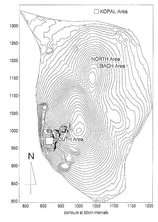
Figure 5: Burial 464
Figure 6: Burial 492
Figure 7: Wall painting 4223
Figure 8: South Area as excavated in 1960s
Figure 9: Level VII
Figure 10: Level VIII
Figure 11: Level IX
Figure 12: Level X
Figure 13: Levels XI, XII and pre XII
Figure 14: Multiphase plan of Building 2 as excavated in 1998
Figure 15: Final phase of Space 170, as excavated and reconstructed.
Figure 16: Reconstruction drawing of Building 16
Figure 17: Reconstruction drawing of Building 18
Figure 18: Gully [5269] and associated features
Figure 19: Gully 5295
| |
© Çatalhöyük Research Project and individual authors, 1999