ÇATALHÖYÜK 2000 ARCHIVE REPORT
    |
Excavations at Çatalhöyük West
Batı Çatalhöyük
Catriona Gibson, Naomi Hamilton and Jonathan Last
with contributions by Peter Boyer
Abstract
Excavations on the West Mound in 2000 revealed a new type of architecture belonging to the Early Chalcolithic period. A series of superimposed structures was excavated, consisting of a mixture of adjoining small and large rooms, and small cell-like rooms without doors. Walls are of mud-brick, but are rarely plastered, and many surfaces were simply trodden earth although a few plastered surfaces were found. Three bins were found arranged in a row, and a range of grains and seeds were recovered from one of them.
Three graves of the classical period were also excavated, overlying the Chalcolithic building. Two were stone-built tombs, the third an earthen grave with tiles covering part of the skeleton.
It is hoped to continue excavations next year.
Özeti
2000 senesinde Batı Höyükte yapılan kazılar, Erken Kalkolitik dönemine ait yeni bir tür mimari açığa çıkarmıştır. Bir dizi birleşik küçük ve büyük odalar ile kapısız, hücre benzeri odalardan oluşan eklemeli yapılar kazılmıştır. Duvarlar kerpiçten yapılmış, ancak nadiren sıvalanmışlardır ve tabanların çoğu sıvalı birkaç yüzey dışında sıkıştırılmış topraktan oluşmuştur. Yan yana dizilimiş üç ambar açiğa çıkarılmış ve bir tanesinin içinden çeşitli tahıl ve tohumlar ele geçmiştir.
Kalkolitik döneme ait binanın üzerinde Klasik döneme ait üç tane mezar kazılmıştır. Bunlardan iki tanesinin duvarları taştan olup, diğeri basit bir toprak mezardır ancak iskeletin bir kısmı kiremit parçaları tarafından örtülmüştür.
Kazıların seneye de devam edeceği umulmaktadır.
Introduction
Five weeks of excavation took place on the West Mound at Çatalhöyük during July and August 2000, funded by the Wainwright Trust, the British Institute of Archaeology at Ankara, the University of Edinburgh Development Trust and the Çatalhöyük Research Project. The excavation was directed jointly by Catriona Gibson, Naomi Hamilton and Jonathan Last, assisted by a small team of British and Turkish archaeologists, students and local workers. This preliminary report summarises the main findings from the 2000 season; further work on the artefactual and environmental data will be carried out in the next few months and at Çatalhöyük in 2001.
Background and Aims
The West Mound at Çatalhöyük was identified as an Early Chalcolithic site by James Mellaart in the 1960s. Although the small excavations carried out by Mellaart in 1961 produced a significant pottery assemblage, little evidence of coherent architecture was recovered (Mellaart 1965). In 1994 surface scraping in three 10 x 10 m squares across the mound also failed to find well-preserved architecture close to the surface, in contrast to the success of this method on the Neolithic East Mound. In 1998, selected areas of Mellaarts two trenches were re-opened with the aim of gaining a better understanding of the nature and preservation of the archaeology, especially architectural remains, and of the ceramic sequence. These results have been detailed elsewhere (Last 1998). Rather surprisingly, it was discovered that the corner of a mudbrick structure was present in the north-east corner of Mellaarts Trench I, on the summit of the mound. This building appeared to be well-preserved at a level c 0.7 m below the surface of the site, and revealed plastered walls and beaten earth floors. In the top of the building fill a unique collection of potstand-like horned clay objects was found, perhaps placed as some kind of closure deposit (Last 2000).
The discovery clearly warranted further investigation, especially as so little was known about the nature of occupation on the West Mound and how it compared with the preceding Neolithic settlement, 400 m to the east. Hence the 2000 season was planned with the aim of extending the excavation area towards the north and east in order to expose in its entirety the Chalcolithic building discovered in 1998, and excavate as much of the structure as possible. Further aims included the recovery of artefactual and environmental data, to build a more rounded picture of the Early Chalcolithic occupation, comparable with contemporary sites like Can Hasan and with the detailed picture being put together for the East Mound. Several samples suitable for radiocarbon dating have also been collected, since the chronology of this period remains poorly understood. Additionally, a core was taken through the site by Peter Boyer, giving a view of the deposits beneath the current excavation and enabling the recovery of datable samples from the earlier part of the West Mound sequence (see below).
Methodology and Summary of Results
An area measuring 10 x 10 m was laid out and stripped of vegetation in the vicinity of the expected building. A 10 x 5 m trench was then opened in the southern half of this area, close to Mellaarts trench; this was subsequently extended slightly to the south, removing the baulk between the new trench and Mellaarts, and the west, to fully expose the western wall discovered in 1998. The overall area of excavation was c 12 x 6 m, though little more than topsoil was removed in the eastern 3-4 m. The topsoil was excavated by hand in spits within 5 x 5 m squares (east and west) until intact archaeological deposits were reached.
The recording system matches that used on the East mound, with unit, graphics, space and building numbers following the main Çatalhöyük sequence. Consequently the West Mound structure has been labelled Building 25, although until details of stratigraphy are settled this remains provisional, since we may be dealing with parts of more than one building. Initial impressions are that conceptions of architectural space changed somewhat between the Neolithic and Chalcolithic, with a series of small, self-contained walled spaces rather than larger rooms sub-divided by platforms as in the archetypal East Mound house. It therefore seems more appropriate to use the individual space numbers (189 - 197) as the basic architectural units, assigning them to one of four Early Chalcolithic building phases provisionally identified within the trench.
Three rows of spaces were revealed, separated by east-west walls. All seem to represent internal rooms rather than unroofed courts or middens. They comprise:
- in the south, from west to east, Spaces 189 (part of which was excavated in 1998), 190 (an earlier phase below this is termed space 197) and 191
- in the centre, 192 (east) and 193 (west)
- in the north, 194 (west) and 195 (east)
The 1998 work indicated that the uppermost floor in Space 189 underlay c 1 m of building fill (in two distinct horizons) with the potstand deposit directly above these fills. In 2000 we found the spaces to the north had surfaces or floors at significantly higher levels than that found in 1998. Hence the site can be provisionally phased as follows (further work may subdivide Phases 3 and 4):
|
Phase |
Description |
|
1 |
Early walls and floor in Space 189 (found in 1998) and equivalent deposits |
|
2 |
Rebuilt walls in Spaces 197 & 193 (no surfaces excavated) |
|
3 |
Scrappy surfaces in Spaces 189, 190, 192 and 193 and perhaps also the lower plaster surface in Space 194 and burnt surfaces in 195 |
|
4 |
Upper plaster surface in Space 194, perhaps associated with some heavily truncated walls further south, as well as the potstands and related deposits |
Overlying the Chalcolithic remains were three Classical period graves, two of them stone-lined, which utilised parts of the prehistoric walls in their construction, suggesting these were still visible at ground level 1500 years ago. The graves also served to obscure some of the key relationships between the walls.
In sum the excavation explored parts of several superimposed Chalcolithic occupation levels, rather than a complete single-phase building, producing rich data which pose many problems and questions, some of which will only be answered by further excavation in future seasons.
The Excavations
Classical Burials
The upper c 0.4 m of the mound consists of a ploughsoil disturbed in recent times by the digging of pits for the winter storage of chaff. This soil contains a number of human bones, indicating that ploughing post-dates the burials, which are apparently Christian (supine, extended inhumations on an east-west orientation with few accompanying artefacts) and - until specialist analyses of the finds are available - provisionally dated to the late Roman or Byzantine periods (possibly 4th-8th centuries AD). A Classical period site, perhaps a small rural settlement (not a tell), is known from surface finds to the south-east of the East Mound at Çatalhöyük and this is presumed to be the origin of the burials on both mounds.
Three graves were excavated this season and a number of disturbed human remains came from other units. The presence of more burials is suspected in the eastern part of the trench, where only limited excavation took place.
In the south-west of the trench, Grave F706 had been discovered (but not excavated) during the 1998 work, while cutting back the northern edge of Mellaarts trench. It proved to be a simple east-west inhumation, perhaps in a coffin (a few displaced nails were found), containing the skeleton of an adult male with a withered arm, possibly the result of polio or a similar disease. The burial had been covered with three half-tiles decorated with curvilinear impressions, typical of late Classical graves elsewhere in the Konya Plain. The cut survived to a depth of c 0.7 m below the modern ground surface.
Grave F700, found towards the centre of the trench, was a stone-lined tomb (missing its eastern end) containing clear evidence of a wooden coffin and the badly preserved skeleton of a small adult female, accompanied by a copper alloy signet ring on the left hand and a bone spindle by the shoulder. The lining consisted of unworked and unmortared limestone slabs built against the sides of the grave cut, which was much wider than that of F706, and forming a pavement beneath the burial. The uppermost stones were found at a depth of 0.57 m below the present surface, and it is possible that a line of disturbed mudbricks found in the ploughsoil immediately to the north and east represents the upper part of the grave - although they may equally relate to a disturbed group of human bones found in an irregular cut just north of F700.
The second stone-lined tomb, Grave F709, was found in the western part of the trench and contained traces of a coffin with the disturbed skeleton of an adult male (the skull had been largely removed by animal activity). This grave had been built partially on the stubs of Chalcolithic mudbrick walls. It was later robbed for its stones, which survived only on the north and east sides, highest in the east where they were encountered only 0.26 m below the ground surface. Underneath the skeleton a stone pavement also survived at the eastern end of the grave. Unlike F700, some mortar was apparent, bonding the stones of the northern wall.
No anthropological study of the Classical human remains has yet been carried out but they are of some interest in their own right and potentially also valuable as a comparative group for the Neolithic population from the East Mound. Precise dating is difficult at present but small quantities of Classical pottery from the topsoil deposits may be helpful. The majority of the diagnostic sherds appear to be mid-Byzantine in date (c 8th century AD) although there are smaller amounts of mid-Roman Aegean cooking pots in micaceous fabrics, a single piece of 1st century AD grey ware and an unusual Iron Age/Hellenistic painted cylindrical neck (information from Daniella Cottica). It seems possible that this material dates the ploughing of the site and that the graves therefore pre-date the 8th century.
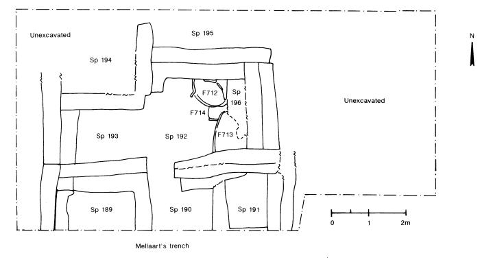
The Chalcolithic Architecture (Figure 17)
After removal of the ploughsoil, initial cleaning of the area brought to light what appeared to be a number of mudbrick walls delimiting rectilinear rooms - three small cells to the south (Spaces 189-191), two larger central rooms (192/196 and 193) and two of uncertain size in the north (194 and 195; not fully revealed in the trench). Several walls seemed to be doubled, like those exposed in 1998.
Compared with the architecture of the East Mound a number of problems presented themselves:
- the plastered faces so common in the Neolithic were not regularly encountered and the dry, disturbed upper walls were frequently hard to recognise. Careful cleaning and allowing time for edges to weather out helped the situation.
- some relationships were obscured by the later graves, especially around F700 (which had truncated the east wall of space 192) and F709 (the wall between Spaces 193 and 195).
- upon investigation, some possible walls proved to be only one brick deep, and they should thus be regarded as possible remnants of a late phase of occupation (Phase 4), perhaps contemporary with the spreads of pottery described below.
Stratigraphic interpretation is therefore complex and not yet finalised. Here the provisional phases are simply described in the order they were encountered (from later to earlier).
At the northern end of the trench a number of surfaces were found. In Space 194 a white plaster floor, with its highest point just 0.59 m below the present ground surface, sloped down from east to west (Phase 4). It was truncated by Grave F709 to the south and partly bounded by a stub of wall to the west, although by the northern edge of the trench it extended beyond the line of this wall, perhaps through a doorway. Similar wall remnants were noticed to the south between Spaces 192 and 193, which were not divided during the earlier phases.
Beneath this (Phase 3), a more level surface ran up to a narrow bench, also plastered, against the western wall of Space 194. This lay further west than the back wall of Space 193 to the south; a short plastered wall projected eastwards from the southern end of the bench and then ran southwards under grave F709 on the same line as the western wall of 193. The dogleg in the wall had an unusual rounded corner with well-preserved plaster.
To the east in Space 195, a series of scrappy burnt surfaces was found, perhaps contemporary with the remnants of a possible plaster bin or basin at the west end of the space. The uppermost surface occurred at a depth of some 0.73 m. These can also be assigned to Phase 3 since the plaster feature underlies the mudbrick bounding the Phase 4 surface in 194. Carbonised wheat (emmer) was found in association with these surfaces.
In the central and southern row of spaces no surfaces of Phase 4 were found but layered spreads of material appear to represent informal or truncated occupation. These consisted of scatters of large potsherds (see below), animal bones, groundstone tools and pieces of red ochre. Whether they were on natural ground surfaces post-dating the structure (as perhaps suggested by large number of phytoliths on the outer surfaces of some artefacts) or informal surfaces within the truncated Phase 4 walls is not yet clear. The occurrence of joining sherds across spaces which had previously been divided by walls suggests that these spreads might post-date the occupation of B.25 (Phase 5). However they also appear to have links with material in the room fills of Phase 3 so are provisionally grouped with Phase 4.
Phase 3 was the earliest definite occupation uncovered in the southern and central areas of the trench. It remains unclear whether this is contemporary with the lower surfaces in Spaces 194 and 195; further analysis may suggest this phase should be sub-divided. The Phase 3 plaster floor in 194 was not removed but in Space 195 east-west walls appearing beneath the burnt surfaces may relate to Phase 2.
The Phase 3 activity in the centre of the trench consists of a structure with one long room (spaces 193/192/196 measuring 4.6 - 5.0 (east-west) x 1.8 m at its greatest). Along with the three small spaces to the south (189: 1.12 x 1.64 m; 190: 1.60 x 1.20 m; 191: 1.80 x 1.20+ m), which were probably in contemporary use but did not all reveal surfaces at this level, it may make up a complete building. This structure would have had internal measurements of 4.0 x 4.6 m and double walls dividing it from further buildings to the north and south. However, as double walls also occur internally within these spaces, it is possible that the northern spaces (194-5) are also part of this building. Neither the walls nor floors of Phase 3 were plastered, making identification more difficult than it is on the East Mound, but the walls survive to a height of 0.5 - 0.6 m.
Spaces 192 and 193 were initially thought to be divided by a wall, but this turned out to be a probable Phase 4 remnant overlying infill. Between Spaces 192 and 196 a series of mudbrick and plaster bin structures was found running across the space. This lies close to the eastern wall, which was eventually revealed in the base of grave F700, indicating that 196 is just a small space behind the bins. The northernmost bin included a groundstone object built into its structure and a range of botanical remains was also recovered. No formal floors have been found in these spaces, but scraps of trodden earth surfaces were associated with the bins in 192 and 196, as well as in Space 193, where a spectacular plaster bowl or basin (see below) was found upright and apparently in situ. The upper part of a large basket-handled pot was found within the infill in Space 192, while the lower part of the same pot was recovered from the doorway leading to Space 190. This doorway (F725) seems to have been blocked deliberately before a Phase 4 wall was built across it, suggesting purposeful burial of the pot. Thus in this part of the trench the Phase 4 structure seems to have been more compartmentalised than in Phase 3, which has a fairly open plan.
Spaces 189 and 191 are small rooms in the southern corners of the building and have no evidence of ground-level access. Space 189 had abundant red-painted plaster in the fill, as did space 190, suggesting the presence of painted wall plaster either higher up on the walls (unlikely) or on a collapsed upper storey. Large amounts of rammed clay with heavy reed impressions were also found in the fill of these two rooms, probably remains of a ceiling/roof or an upper storey of lighter construction. A beaten earth surface was found in Space 189 and another against the eastern wall of 190, both roughly level with those found in the central spaces. No surface was recognised in Space 191, but a junction between two fills at a similar level to the rough surface in 190 may represent a phase of occupation.
Phase 2 is not as well known as Phase 3. Upon removal of the surface in Space 190 and excavation of the lower fill, an earlier set of walls on a slightly different alignment was found. These walls were faced with white plaster, similar to those which can be seen emerging at the same level in Space 193, slightly offset from the Phase 3 walls above. They survive to a height of 0.4 - 0.5 m. A narrower doorway apparently led from Space 197 (below 190) into the precursor of Space 192, but the latter area has not yet been excavated. The different alignment of walls can also be picked up - though less clearly - in Spaces 189 and 191 (not yet assigned separate space numbers at this level). However, further excavation is required to understand the complete layout of the Phase 2 building and it is not yet clear whether this building was significantly different in plan from that of Phase 3.
Phase 1 is also known at present only from the three southern cells. Close examination of the walls shows that a similar slight change in alignment took place during the construction of Phase 2 in all three spaces, so that the lowest 0.4 m of the walls should be assigned to Phase 1 (separate space numbers have not yet been assigned). In Space 189 this phase is represented by a beaten earth surface which was initially uncovered on its southern edge during 1998. There appears to be a plaster floor beneath the earth surface, but this must be confirmed by further excavation. In the southern part of Space 197 are the broken remains of what appears to be an oven, while plaster features have been exposed in the north. However, the surface in this phase has yet to be excavated. The altered alignment of the walls between Phases 1 and 2 is clearest in this space, as was the change between Phases 2 and 3. Space 191 was excavated to the same level as 189, revealing a mudbrick bench (F720) along the eastern wall which probably belongs to Phase 1. This overlies a rectangular feature at the southern end of the room which may turn out to be an earlier wall.
To the south of these three spaces is an area that was assumed to represent external surfaces when sampled in 1998, which would also correspond with the yard deposits apparently encountered by Mellaart in his trench (although it is now clear that some of the walls of B.25 were not recognised in 1961). This may be correct (no further excavation here was undertaken in 2000) but in the base of Mellaarts trench the eastern wall of Space 191 appears to continue southwards and there are traces of plaster suggesting internal features and a further building to the east.
On the east side of B.25 the intact Chalcolithic levels were not fully exposed, partly because it was suspected further Classical graves were present. However the eastern section of grave F700, which lay beyond the eastern wall of Space 192, showed stratified deposits that probably represent surfaces. The eastern face of this wall was plastered so it is almost certainly another internal space. Cleaning the grave section revealed at least three undulating plaster layers associated with mudbrick collapse; micromorphological analysis of these deposits is awaited. Further east again, about 1 m from the eastern end of the trench, the top of a further north-south oriented wall was exposed. This evidence suggests further work is necessary to confirm the eastern extent of B.25.
More walls were observed running into the western baulk, perhaps showing the continuation of the central row of Space 196/192/193 in this direction, though no direct access is evident between 193 and a space to the west. It was notable that in this western section the walls were seen to survive to a relatively high level, suggesting it may be possible to clarify the nature of Phase 4 occupation in this area.
The phasing and stratigraphy of the buildings found in 2000 is not complete, but it is clear that several construction events took place and in general the same groundplan appears to be present in several superimposed buildings. Further excavation work will clarify this, particularly in the central and northern parts of the trench where only the later phases are currently known. The building plan found so far bears little resemblance to Chalcolithic structures known from other sites, such as Can Hasan, or indeed the building partly excavated by Mellaart in Trench II on the southern side of the West Mound. In both cases a large rectangular building with internal spaces divided by buttresses is suggested, rather than the small self-contained spaces with a mixture of single and double walls seen in the current excavations. Indeed the lack of a continuous outer wall and the absence of doorways in Spaces 189 and 191 means that we are still uncertain whether all the rooms exposed belong to a single building, or indeed if there are more spaces that should be included in B.25. Similar rows of small rooms without evident entrances are known from the Neolithic levels on the East Mound (Bach area), though most other elements of the West Mound building plan are radically different from the earlier period. The discovery of a new style of architecture at Çatalhöyük West is exciting, and we hope to continue our investigations in further seasons so that the nature of Early Chalcolithic settlement and architecture can be better understood.
The Coring by Peter Boyer
During the 2000 season, coring was carried out in the base of the trench where excavation had ceased in 1998. The aim was to establish the nature and extent of underlying deposits and provide material which could be used to radiocarbon date deposits earlier than those that have been currently excavated, thus providing a broad chronology for the site.
The coring was carried out by hand using a corer with a Dutch auger head and 1 m extension rods. Earlier attempts to use a Dachnowski coring head proved unfruitful, because of the nature of the sediment. The top of the core was at an elevation of 1006.53 m.
The upper 1.03 m of the core consisted of various dark greyish-brown silty clay deposits containing a range of cultural debris that included pottery, animal bone and charcoal. These layers were clearly cultural deposits, as would be expected. However, between 1.03 and 1.55 m in depth (1005.50 and 1004.98 m), a stiff, slightly plastic silty clay was excavated. This appeared to be devoid of cultural material and had more in common with natural alluvial clay. Below 1.55 m cultural material once more began to appear. Dark greyish brown silty clay deposits with cultural material persisted from 1.55 - 2.06 m. At this point, the deposits became much paler, although cultural material still persisted. Below 2.55 m, the deposits became more variable, but still contained a clear cultural element.
At a depth of 3.60 m, a layer of friable yellow plaster, 3 cm thick, was encountered. This gave the appearance of a floor, and therefore deposits within a building may have been encountered. Visible cultural deposits persisted to a depth of 4.90 m (1001.63 m). Below this, cultural material disappeared once more, replaced by natural sediments and, below 5.09 m, a natural greyish alluvial clay silt.
The core sequence showed two broad cultural phases, and two phases of apparent natural sedimentation. This pattern differs markedly from previous research at Çatalhöyük. A mechanically excavated core taken through the West Mound in 1996 clearly showed cultural deposits persisting down to an elevation of c 999.4 m, with no breaks in activity. This is well below the level of both natural phases observed in the 2000 core, and suggests that the recent core did not reach the base of cultural deposits. More intriguing is the presence of the two natural phases. The lower phase may have been above a Chalcolithic land surface, but could conceivably represent a significant flood. It was not, however, recognised in the 1996 core. The upper phase is above even the present land surface and must therefore represent something other than flooding. It may be that it was a homogeneous cultural deposit with little obvious cultural material. The fine silty clay may be the product of the breakdown of mudbrick (alluvial clay). It is most likely that the generally sterile deposits represent phases of abandonment. This could have been very localised and merely represent phases within a single structure or groups of structures, which would explain the lack of sterile deposits in the 1996 core.
A parallel core was taken next to the first one, and a number of samples were collected for radiocarbon dating on the basis of the records of the first core. Seven samples were taken at various depths from deposits where significant quantities of organic material were present. Radiocarbon dates are expected from three of these samples.
Acknowledgements
We are grateful to the trustees of the funding bodies which gave grants for this work; Professor Ian Hodder, for allowing and supporting the West Mound project, which is covered by his permit; the Turkish government representatives who assisted us in many ways; various Çatalhöyük Project specialists for their input and interest (particularly Shahina Farid, Sheelagh Frame, Meltem Ağcabay, Kent Severson and John Swogger), our small staff (Pete Boyer, Serap Özdol, Burcu Tung, Nurcan Yalman, Perihan Kösem, Serdar Cengiz) and workmen, who laboured hard, often in extraordinary heat, to produce excellent results.
References
Last, J., 1998. Excavations on the West Mound at Çatalhöyük, 1998.
Last, J. 2000. Discussion: Interpreting the unique. Archaeological Dialogues 7, 66-70.
Mellaart, J. 1965. Çatal Hüyük West. Anatolian Studies 15: 135-56.
Figures
Figure 17. The West Mound excavations
| |
© Çatalhöyük Research Project and individual authors, 2000