ÇATALHÖYÜK 2003 ARCHIVE REPORT
    |
SOUTH AREA
Shahina Farid
Abstract
The South Area shelter project for which the foundation trenches were excavated in 2002, was finally completed in February 2003.The new South Area now incorporates the Summit Area which is now called South-Summit. Aims to reopen excavations now covered by the new shelter that have not been worked on since 1999 (and South Summit since 1997), were held back as the season had been reduced in time and size. Instead resources were concentrated on preparing the newly covered larger area for excavation and presentation in 2004. This involved clearing vegetation and erosion built up since 1999 and 1997, removing sand (soil) bags which were used to protect the excavated areas up to 1999, and a thorough cleaning with trowels of the exposed sections and wall faces for better presentation to the public. Small scale excavations were resumed in Building 10, South-Summit, after 5 long years, in order to bring the building into a single phase of occupation.
Plans for visitor accessibility into the area were also discussed with Atolye Mimarlik and designs of wooden platforms and steps are currently underway. Some temporary measures for accessibility were put in place and a reconstruction of the ‘volcano painting’ found by Mellaart was produced and erected in as close to its original location as possible.
Özet
Temelleri 2002’de kazilan Güney Bölgesi koruyucu çati projesi subat 2003’te tamamlanmistir. Yeni Güney Bölgesi, 10 nolu binanin kazisinin tamamlanmasina kadar Güney-Zirve olarak adlandirilacak olan Zirve Bölgesini de kapsamaktadir. 1999 yilindan bu yana kazilmamis olan yeni çati altinda kalan bölgeyle, kazisi 1997 yilinda birakilan Güney Zirve’nin yeniden kazilmasina dair planlar, kazi sezonunun zaman ve kapsam olarak daraltilmis olmasi sebebiyle geri çekilmistir. Böylelikle kaynaklar, üzeri kapanan alanin 2004 yilinda kazi ve sunuma hazirlanmasi üzerine yogunlastirilmistir. Bu çalisma, 1999 ve 1997 yilindan bu yana olusan bitki örtüsünün ve erozyon dolgusunun temizlenmesi, 1999 yilina kadar kazilan bölgeleri korumakta kullanilan toprak torbalarinin kaldirilmasi, ve açilmis olan bölümlerin ve duvar yüzlerinin halka daha iyi sunulmak amaciyla malalarla temizlenmesini kapsamistir. Ayrica, 5 yillik uzun bir aradan sonra, Güney Zirvedeki 10 nolu binayi yerlesmenin tek bir evresine getirmek amaciyla küçük ölçekli kazilara yeniden baslanmistir.
Bu bölgenin ziyarete açilmasina yönelik planlar Atölye Mimarlik ile tartisilmis olup, ahsap platform ve basamaklar için tasarimlar hazirlanmaktadir. Ayrica, Mellaart tarafindan bulunan “yanardag resmi”nin gerçegine mümkün oldugu ölçüde sadik kalan bir kopyasi, ziyaretçilerin yerlesmeyi daha iyi anlayabilmeleri amaciyla, orijinal yerine yerlestirilmistir.
The South Area shelter project for which the foundation trenches were excavated in 2002 (Farid Archive Report 2002), was finally completed in February 2003. Therefore it was with great excitement that the team involved with this particular project arrived at the site to see the shelter in its complete state for the first time. Neither the plans nor the images taken during its construction over the winter months had prepared us for the enormity of the project in its complete state. For the design and the work the project is very grateful to Ridvan Övünç, Sinan and Didem Omacan and Ceren Balkir of Atolye Mimarlik, Istanbul.
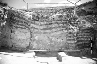
The shelter measures 45m x 27m drops from a height of 1014.9m AD (meters above Datum) from the east to 1006.9m AD to the west and covers the South and Summit excavation areas that represent Levels V to natural. The shelter has created a wonderful even light and a protected environment for excavation, conservation and public display (Fig. 34). As two excavation areas have now become one, the area will continue to be known as the South Area, and Summit as South Summit until the completion of excavation of Building 10. This will differentiate the excavations conducted in 1996-97 by the team headed by Kostas Kotsakis from the University of Thessaloniki, and the current excavations undertaken by the Stanford-Cambridge team.
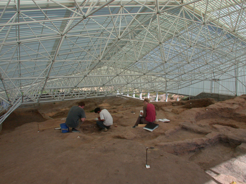
Figure 34: Conditions under the South Area shelter
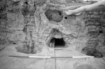
The aim for 2003 had been to clean and then to excavate those buildings that were under excavation in 1999 but because of the shortened and reduced season, plans for the South Area were amended. As such a small team of excavators with local workmen cleared the backfill and conducted a thorough clean of the area (Fig. 35).
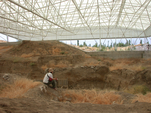
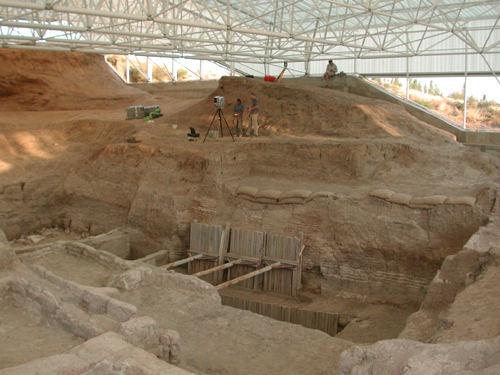
Figure 35: Before and after cleaning under the South Area shelter
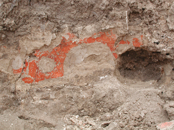
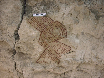
Whilst removing backfill from Building 2, Level IX, a fragment of red paint on the north wall was exposed. Upon preliminary investigation it became apparent that it was part of a design (Fig 36), rather than a plain band of red paint as is sometimes found. As the painting was only revealed towards the end of the season it was decided not to expose it fully but to conserve and cover it instead until the next season when complete investigation, conservation and lifting can be conducted. The painting is in a building that was excavated between 1997- 99 (see Archive Reports). Building 2 consists of two rooms, a small eastern room designated Space 116, that has not yet been fully exposed, and a larger room, Space 117, that was completely excavated of its occupation phases. The north wall was left in situ as it was not released for excavation due to overlying later deposits to the north. Furthermore, its wall plaster was not removed as the wall was in danger of collapse and such work was considered too dangerous. However, plaster on other walls of Space 117 was removed and a geometric-type painting of red pigment on white plaster was found on the east wall, north of the access hole to the next room (Fig.37). The location of this new piece is centrally placed between two posts and above two oval-shaped wall niches, one of which is at floor level and the other above it; the painting is situated above the upper niche.
 |
 |
 |
 |
Figures 36&37: Building 2. North wall with painting exposed in 2003 and east wall with painting exposed in 1999
Other work in the South Area involved monitoring the plaster on the walls of Building 17, Level IX (see Conservation below).
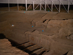
Taking advantage of the 3-D laser scanner being on site, after the scanning work was completed on Building 5, the scanner was used in a small test section in the South Area. As time was short, this work was conducted at night but nonetheless successfully (Fig. 38).
Finally, although not programmed for the 2003 season, it was appropriate to begin re-excavating Building 10 of the South Summit Area (see below), as work in the new 4040 was making good progress and resources could be diverted.
The long term objective for the area is to excavate the upper ledge to the east (South Summit etc.), of Levels VI and later as well as to continue excavations to ‘natural’ towards the centre in as large an area as possible whilst fulfilling Health and Safety requirements. It is also planned to present well preserved buildings for display where possible. It was with this aim of presenting the area to site visitors that a reconstruction of one of the wall paintings found by Mellaart in the 1960’s was made and erected in its original location (see Conservation below and Fig. 5).
 |
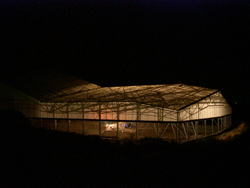 |
Figure 38: Laser scanning by night: views from interior (left) and exterior (right)
| |
© Çatalhöyük Research Project and individual authors, 2003